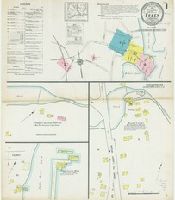
Sanborn fire insurance maps are a rich source of historic data on the urban built environment of North America during the 19th and early 20th centuries. The atlases were created for the purpose of underwriting fire insurance policies, which depended upon accurate and frequently-updated information about construction materials, municipal and transportation infrastructure, industrial and commercial landuse and more. The Yale University Library Map Department scanned its holdings of Sanborn fire insurance maps (consisting primarily of Connecticut towns) in order to make the maps more accessible.
Alternative Title:
Feb. 1914, Essex, Conn.
Description:
"6642. (8 sheets).", "Including Centerbrook & Ivoryton.", Contains information on population, prevailing winds, water facilities and fire department., Includes index of streets and specials., Partial cadastral map., and SMLMAPL 766 Es75 1914: Sheets disbound. "Triplicate" stamp on all sheets. Library of Congress copyright and Map Division stamps on title sheet.
Subject (Geographic):
Essex (Conn. : Town)--Maps
Subject (Name):
Library of Congress Stamp
Subject (Topic):
Fire risk assessment--Connecticut--Essex (Town)--Maps and Real property--Connecticut--Essex (Town)--Maps
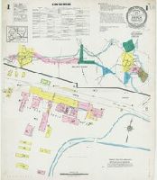
Sanborn fire insurance maps are a rich source of historic data on the urban built environment of North America during the 19th and early 20th centuries. The atlases were created for the purpose of underwriting fire insurance policies, which depended upon accurate and frequently-updated information about construction materials, municipal and transportation infrastructure, industrial and commercial landuse and more. The Yale University Library Map Department scanned its holdings of Sanborn fire insurance maps (consisting primarily of Connecticut towns) in order to make the maps more accessible.
Alternative Title:
June 1925, Essex, Conn.
Description:
"(2273) (8 sheets).", "Including Centerbrook, Ivoryton.", Contains information on population, prevailing winds, water facilities and fire department., Includes index of streets and specials., Partial cadastral map., and SMLMAPL 766 Es75 1925: Sheets disbound. Library of Congress copyright stamp on title sheet.
Subject (Geographic):
Essex (Conn. : Town)--Maps
Subject (Name):
Library of Congress Stamp
Subject (Topic):
Fire risk assessment--Connecticut--Essex (Town)--Maps and Real property--Connecticut--Essex (Town)--Maps
Esso Standard Oil S.A. Limited General Drafting Company
Published / Created:
[c1942]
Call Number:
304 1942A
Container / Volume:
BRBL_00034
Image Count:
2
Resource Type:
Maps, Atlases & Globes
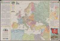
Alternative Title:
Fortress Europe, War map II, and World Island
Description:
"Copyright, General Drafting Co.", Includes text, "The geography of global warfare" and "Peace conference problems," ancillary map "Boundary changes in Central Europe since 1938," and col. ill., and Maps show railroads, roads, pipelines, steamship distances, an
Publisher:
Esso,
Subject (Geographic):
Europe--Administrative and political divisions--Maps
Subject (Topic):
Administrative and political divisions--Maps, World War, 1939-1945--Europe--Maps, World War, 1939-1945--Maps, and World War, 1939-1945--Transportation--Maps
Recto. Europe and North Africa. [Scale 1:6,526,080] Boundary changes in Central Europe since 1938. [Scale ca. 1:14,000,000]. --Verso. The world island [i.e. Eastern hemisphere] Miller cylindrical projection [Scale 1:31,6800,000 or 1 inch = 500 miles at the Equator]
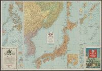
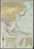
Japan and adjacent Asiatic mainland [cartographic material]., The Pacific Theater [cartographic material]., and War map III featuring the Pacific Theater
Description:
Chart of variants in Chinese place names. and recto. Esso War Map: The Pacific Theater.--South China Coast with inset of Canton-Hong Kong area.--Formosa.--Vladivostok and vicinity.--verso. Esso War map: Japan and adjacent Asiatic mainland.--Philippine Islands
Publisher:
Esso Marketers,
Subject (Geographic):
East Asia--Maps and Pacific Ocean--Maps
Subject (Name):
Esso Marketers
Subject (Topic):
World War, 1939-1945--Campaigns--Pacific Ocean and World War, 1939-1945--Maps
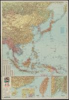
Japan and adjacent Asiatic mainland [cartographic material]., The Pacific Theater [cartographic material]., and War map III featuring the Pacific Theater
Description:
recto. Esso War Map: The Pacific Theater.--South China Coast with inset of Canton-Hong Kong area.--Formosa.--Vladivostok and vicinity.--verso. Esso War map: Japan and adjacent Asiatic mainland.--Philippine Islands with insets of [Bashi Channel, Luzon, and
Publisher:
Esso Marketers,
Subject (Geographic):
East Asia--Maps and Pacific Ocean--Maps
Subject (Name):
Esso Marketers
Subject (Topic):
World War, 1939-1945--Campaigns--Pacific Ocean and World War, 1939-1945--Maps
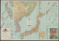
Japan and adjacent Asiatic mainland [cartographic material]., The Pacific Theater [cartographic material]., and War map III featuring the Pacific Theater
Description:
Chart of variants in Chinese place names. and recto. Esso War Map: The Pacific Theater.--South China Coast with inset of Canton-Hong Kong area.--Formosa.--Vladivostok and vicinity.--verso. Esso War map: Japan and adjacent Asiatic mainland.--Philippine Islands
Publisher:
Esso Marketers,
Subject (Geographic):
East Asia--Maps and Pacific Ocean--Maps
Subject (Name):
Esso Marketers
Subject (Topic):
World War, 1939-1945--Campaigns--Pacific Ocean and World War, 1939-1945--Maps
Japan and adjacent Asiatic mainland [cartographic material]., The Pacific Theater [cartographic material]., and War map III featuring the Pacific Theater
Description:
Chart of variants in Chinese place names. and recto. Esso War Map: The Pacific Theater.--South China Coast with inset of Canton-Hong Kong area.--Formosa.--Vladivostok and vicinity.--verso. Esso War map: Japan and adjacent Asiatic mainland.--Philippine Islands
Publisher:
Esso Marketers,
Subject (Geographic):
East Asia--Maps and Pacific Ocean--Maps
Subject (Topic):
World War, 1939-1945--Campaigns--Pacific Ocean and World War, 1939-1945--Maps