[Atlas factice of 42 maps, produced by the Homann Erben firm]
Image Count:
1
Alternative Title:
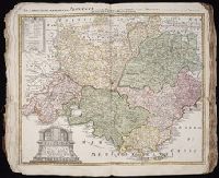
Praefectura Generalis et Comitatus Provinciae
Subject (Geographic):
Alpes de Haute-Provence (France) --Maps --Early works to 1800, Alpes-Maritimes (France) --Maps --Early works to 1800, Bouches-du-Rhone (France) --Maps --Early works to 1800, France, Southern --Maps --Early works to 1800, Var (France) --Maps --Early works to 1800, and Vaucluse (France : Dept.) --Maps --Early works to 1800
Composite atlas of 41 maps from Alexis Hubert Jaillot's Atlas nouveau.
Image Count:
1
Alternative Title:
Provinces-Unies des Pays-Bas, sc̦avoir le Duché de Gueldre, les Comtés de Hollande, Zeelande, Zutphen
Description:
"Avec privilege du Roy.", Boundaries hand colored. Sheets measure 62.8 x 47.0 cm or smaller. No. 17 of 41 maps bound together with binder's title: Carte de Sanson., Cartouche signed "F. Chauveau in. et fe.", From Jaillot's Atlas nouveau (1681)., Includes 6 bar scales., Prime meridan: Ferro., Relief shown pictorially., and Watermark.
Publisher:
Chez H. Iaillot joignant les grands Augustins aux deux globes,
Subject (Geographic):
Netherlands--Maps--Early works to 1800 and North Rhine-Westphalia (Germany)--Maps--Early works to 1800
[Atlas factice of 42 maps, produced by the Homann Erben firm]
Image Count:
1
Alternative Title:
Cercle d’Autriche : consistant dans l’Archiduche d’Autriche, le Duche de Stirie, de Carinthie, de Carniole, dans la Comte de Tyrol, et les pais autrichiens anterieurs dans la Souabe, avec ses confins, Circulus Austriacus, and Circvlvs Avstriacvs
Publisher:
Curantibus Homannianis Heridibus
Subject (Geographic):
Austria --Maps --Early works to 1800 and Europe, Central --Maps --Early works to 1800
[Atlas factice of 42 maps, produced by the Homann Erben firm]
Image Count:
1
Alternative Title:
Etats de l’Eglise & du Grand Duche de Toscane, Etats de l’Eglise & du Grand Dvche de Toscane, and Status Ecclesiastici nec non Magni Ducatus Toscanae nova tabula geographica
Publisher:
Curantibus Homannianis Heredibus
Subject (Geographic):
Papal States --Maps --Early works to 1800 and Tuscany (Italy) --Maps --Early works to 1800
Mortier, David Mortier, Pierre Sanson, Nicolas, 1600-1667, creator
Published / Created:
[1710]
Call Number:
1973 Folio 10
Image Count:
1
Resource Type:
Maps, Atlases & Globes
Alternative Title:
Premiere carte de la Meuse avec les pais, duchez et comtez voisins and Teatre de la guerre en Flandre et Brabant
Description:
Alternate title in upper margin: Premiere carte de la Meuse avec les pais, duchez et comtez voisins., Does not show troop positions or other military locations., Ferro meridian., Imperfect: western sheet (with title cartouche) wanting. Part of eastern map (inset of Arras/Cambrai region) pasted over correction[?]., Includes inset of Arras/Cambrai region and color illustration of battles at upper left and lower right., No. 47 of 69 maps bound together in composite atlas., Originally printed on 4 sheets., Presentee a son altesse Monseigneur le Duc & Comte [sic] de Marlborough, Marquis de Blandford, &c. &c. &c., par son tres-humble et tres-obeissant serviteur, Pierre Mortier, libraire a Amsterdam., Relief shown pictorially., and Scale [ca. 1:250 000].
Publisher:
Apud Petrum Mortier, et se vend a Londres chez David Mortier
Subject (Topic):
Spanish Succession, War of, 1701-1714 --Maps --Early works to 1800