Portugal. Comissão de Cartografia das Colónias, author
Published / Created:
1907
Call Number:
213 1907
Container / Volume:
BRBL_00015
Image Count:
1
Resource Type:
Maps, Atlases & Globes
Alternative Title:
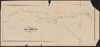
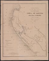
Ilha de S. Thiago and Porto da Praia
Description:
"Levantado em 1902 pelo capitao tenente Christiano José de Senna Barcellos.", Coordinates not present on map and are approximated., and Relief shown by hachures and depth by soundings.
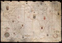
"Feita por João Teix[ei]ra Albernass Cosmographo los Reinos de Portugal por Sua Mag[esta]de. O anno de 1665. L[i]x[bo]a", Contains five compass roses., Decoration: coats of arms in territories., Imperfect: chipped along edges., Manuscript annotations on verso., Pen-and-ink in black, red, blue, yellow and green., Portolan chart with seaport names given for all coastlines., and Title devised by cataloger.
Subject (Geographic):
Atlantic Ocean--Maps--Early works to 1800., Indian Ocean--Maps--Early works to 1800., and Pacific Ocean--Maps--Early works to 1800.
Subject (Topic):
Nautical charts--Atlantic Ocean--Early works to 1800., Nautical charts--Indian Ocean--Early works to 1800., and Nautical charts--Pacific Ocean--Early works to 1800.
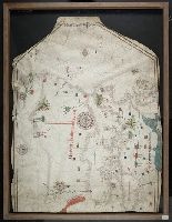
Contains seven compass roses., Decoration: armorial shields and city views with banners., In frame 88 x 115 cm., Pen-and-ink in brown, red, and green., Portolan chart with seaport names given for all coastlines., and Title devised by cataloger.
Subject (Geographic):
Black Sea--Maps--Early works to 1800., Mediterranean Sea--Maps--Early works to 1800., and North Atlantic Ocean--Maps--Early works to 1800.
Subject (Topic):
Nautical charts--Black Sea--Early works to 1800., Nautical charts--Mediterranean Sea--Early works to 1800., and Nautical charts--North Atlantic Ocean--Early works to 1800.