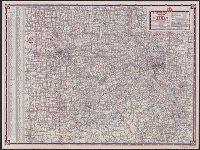
Highway map, Missouri, Missouri, and Standard Oil Company (Indiana), road map, Missouri
Description:
3 maps, ill., and text on verso., At head of title: Standard Oil Company (Indiana), In lower right: W.3712., Indexed., and Relief shown by spot heights.
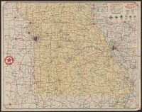
Highway map, St. Louis and Standard Oil Company (Indiana), road map, St. Louis and vicinity
Description:
At head of title: Standard Oil Company (Indiana), In lower right: X.3518, Indexed., Maps of downtown St. Louis, ill., and text on verso., and Relief shown by hachures.
Publisher:
Rand McNally,
Subject (Geographic):
Saint Louis (Mo.)--Maps and Saint Louis Metropolitan Area (Mo.)--Maps
Subject (Name):
Standard Oil Company (Indiana)
Subject (Topic):
Central business districts--Missouri--Saint Louis--Maps, Roads--Missouri--Saint Louis Metropolitan Area--Maps, and Streets--Missouri--Saint Louis--Maps
Highway map, St. Louis and Standard Oil Company (Indiana), road map, St. Louis and vicinity
Description:
At head of title: Standard Oil Company (Indiana), In lower right: U.3815, Indexed., Map of downtown St. Louis, ill., and text on verso., and Relief shown by hachures.
Publisher:
Rand McNally,
Subject (Geographic):
Saint Louis (Mo.)--Maps and Saint Louis Metropolitan Area (Mo.)--Maps
Subject (Name):
Standard Oil Company (Indiana)
Subject (Topic):
Central business districts--Missouri--Saint Louis--Maps, Roads--Missouri--Saint Louis Metropolitan Area--Maps, and Streets--Missouri--Saint Louis--Maps
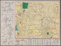
Northwestern United States., Southwestern United States., Texaco road map, northwestern United States., Texaco road map, southwestern United States., and Texaco trip map :
Description:
At head of titles: 1933., Panel title., Relief shown by hachures and spot heights., and Texaco road map, northwestern United States -- Texaco road map, southwestern United States.
Publisher:
Rand McNally,
Subject (Topic):
Roads--Northwestern States--Maps, Roads--Southwestern States--Maps, and Roads--West (U.S.)--Maps
"Texaco road map, 1932, United States," local route maps of Kansas City and St. Louis, distance table, indexes, ill., and text on verso., Date inferred from stamp below title: Apr 28 1932., and In lower right: A4.2716.
Texaco sectional trip map [of western states]., Touring map of Wyoming, and Wyoming with sectional map of adjoining states
Description:
"Texaco sectional trip map [of western states]" (scale [ca. 1:4,181,760]), text, and ill. on verso., "X.3846.", and Includes index, 2 local route maps, and road maps of "Yellowstone Nat'l Park and Grand Teton Nat'l Park, Wyo." and "Black Hills region, S. Dak."
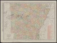
Arkansas, New commercial atlas map of Arkansas, and Rand, McNally & Co.'s new business atlas map of Arkansas.
Description:
At bottom: Rand, McNally & Co.'s new business atlas map of Arkansas. Copyright 1902, by Rand, McNally & Co., Indexed., Library's copy annotated in ink and color pencil to indicate gas and oil fields., and Shows railroads.