Skip to search
Skip to main content
Skip to first result
Search
You Searched For
Format
cartographic
Creator
Rand McNally and Company
Publication Place
Helena, Mont. :
New Search
Search Results
Creator:
Published / Created:
1942
Call Number:
831gmb 1942
Container / Volume:
BRBL_00581
Image Count:
2
Resource Type:
Maps, Atlases & Globes
Alternative Title:
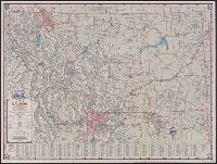
Montana highway map
Description:
In lower right: X 3624., Indexed., Relief shown by shading and spot heights., and Road maps of Yellowstone National Park and Waterton-Glacier International Peace Park, text, distance table, and col. ill. on verso.
Publisher:
State Highway Commission,
Subject (Geographic):
Montana--Maps
Subject (Name):
Montana. State Highway Commission
Subject (Topic):
Roads--Montana--Maps
Found in:
Beinecke Rare Book and Manuscript Library > Map of the Montana state highway system / prepared by Rand McNally & Company.
Creator:
Published / Created:
[1960]
Call Number:
831gmb 1960
Container / Volume:
BRBL_00581
Image Count:
2
Resource Type:
Maps, Atlases & Globes
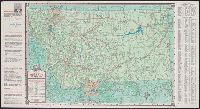
Alternative Title:
1960 Montana highway map and Montana highway map
Description:
In lower right: 0-483624-11., Includes text and index., Photos, text, and distance table on verso., and Relief shown by shading and spot heights.
Publisher:
State Highway Commission,
Subject (Geographic):
Montana--Maps
Subject (Name):
Montana. State Highway Commission
Subject (Topic):
Roads--Montana--Maps
Found in:
Beinecke Rare Book and Manuscript Library > Map of the Montana state highway system / prepared by Rand McNally & Company.
Branch:v1.61.8 ,Deployed:2024-06-20T11:15:02-04:00