
You Searched For
1 - 3 of 3
Search Results
- Creator:
- Great Britain. War Office. General Staff. Geographical Section
- Published / Created:
- [1918?]
- Call Number:
- 38fd 1918
- Container / Volume:
- BRBL_00170
- Image Count:
- 1
- Resource Type:
- Maps, Atlases & Globes
- Alternative Title:
- GSGS (Series) ; 3700.
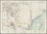
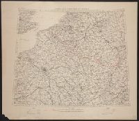
- Description:
- "G.S.G.S. 3700.", Ordnance Survey, November 1918., Relief shown by spot heights., and Shows boundaries as in 1792, 1814, and 1815. To illustrate the post-WW1 settlement.
- Publisher:
- Ordnance Survey,
- Subject (Geographic):
- Belgium--Boundaries--France--Maps, France--Boundaries--Belgium--Maps, France--Boundaries--Germany--Maps, and Germany--Boundaries--France--Maps
- Subject (Name):
- Great Britain. Ordnance Survey
- Found in:
- Beinecke Rare Book and Manuscript Library > North-east frontier of France [cartographic material].
- Creator:
- Great Britain. War Office. General Staff. Geographical Section
- Published / Created:
- 1927
- Call Number:
- BrSides Folio 2018 131
- Image Count:
- 1
- Resource Type:
- Maps, Atlases & Globes
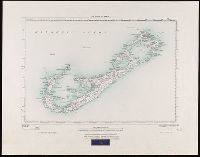
- Alternative Title:
- GSGS (Series) ; 3857
- Description:
- "250/27.", "Surveyed in 1898-99.", Bookseller's label at bottom of sheet: International Map Company, Inc. ... New York. N.Y., Relief shown by spot heights (in feet)., and Shows roads (2 categories) and parish boundaries.
- Publisher:
- Ordnance Survey Office,
- Subject (Geographic):
- Bermuda Islands--Maps.
- Subject (Name):
- Great Britain. Ordnance Survey and International Map Company
- Found in:
- Beinecke Rare Book and Manuscript Library > The islands of Bermuda [cartographic material].