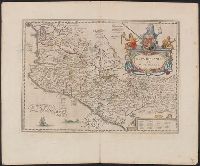
Dutch text of verso, with caption title "Nieuvv Spanien" and signature 2G., From Jansson's Nieuwen atlas ... Amstelodami : Apud Ioannem Ianssonium, 1647., Includes ill., index, and text., and Relief shown pictorially.
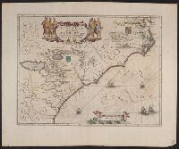
Dutch text on verso, with running and caption title "Virginia," signature 2D, and catchword "riviere.", Hendrik Hondius' derivative of John Smith's map of Virginia, 1612., Oriented with north toward the right., Relief shown pictorially., and Royal arms in upper r
Publisher:
Ex officina Henrici Hondii,
Subject (Geographic):
Chesapeake Bay (Md. and Va.)--Maps--Early works to 1800, Maryland--Maps--Early works to 1800, and Virginia--Maps--Early works to 1800
Subject (Name):
Jansson, Jan, 1588-1664. Atlas novus. Dutch and Smith, John, 1580-1631
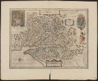
Bar scales in "Miliaria Germanica communia" and "Miliaria Gallica communia.", From Jansson's Nieuwen atlas ... Amstelodami : Apud Ionnem Ianssonium, 1647., Imperfect: torn along fold, with no loss of text. Sheet measures 50 x 61 cm., In Dutch on verso, with caption titles "Peru" and signature 2L., Oriented with north to the left., and Relief shown pictorially.
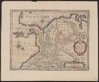
Bar scales given in "leucae Hispanicae" and "milliaria Germanica communia.", From Jan Jansson's Nieuwen atlas ... Amsterdami : Apud Iohannem Ianssonium, 1647., Relief shown pictoria, and Shows southern part Central America and northwestern part of South America.
Publisher:
Joannes Janssonius excudit,
Subject (Geographic):
Colombia--Maps--Early works to 1800, Panama--Maps--Early works to 1800, and Venezuela--Maps--Early works to 1800
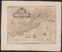
Appears in various, Hand col. Sheet measures 50 x 60.9 cm., Latin text on recto; Dutch text on verso., Prime meridian Ferro., Relief shown pictorially., and Verso in Dutch, with running and caption title "Florida," signature 2E and catchword "rivieren".
Cross Collection no. 60., From Janssonius's Niewen atlas ... Amstelodami : Apud Ioannem Ianssonium, 1652., Hand col. Mounted on linen., Includes marginal ill., Relief shown pictorially., Title supplied by cataloger., and Variant of Hondius' Polus Antarcticus, 1638.
Publisher:
J. Jansson,
Subject (Geographic):
Antarctica--Maps--Early works to 1800 and Southern Hemisphere--Maps--Early works to 1800