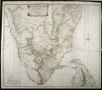
Map with relief shown pictorially, by hachures, and bathymetric soundings., No. 32 of 43 maps bound together in composite atlas., and Scale [ca. 1: 720 000].
Publisher:
Printed for Wm. Faden
Subject (Geographic):
India, South --History, Military --Maps --Early works to 1800
Dominions of Turky in Europe in which are the governments of Romelia of the sea, of Buda, of Teme's war, and of Bosnia ... described by Sanson, corrected and amended by William Berry
Description:
Bar scales in Italian miles, common leagues of France, common leagues of Germany or great leagues of Poland, leagues of Hungary, and leagues that are of one hours travelling., Dedicated To the most serene and most sacred majesty Charles II ... by William Berry., No. 24 of 69 maps bound together in composite atlas., Relief shown pictorially., and Scale [ca. 1:3 500 000].
Publisher:
Sold by William Berry at the signe of the Globe between Charing-Cross and White-Hall
Subject (Geographic):
Balkan Peninsula --Maps --Early works to 1800, Italy --Maps --Early works to 1800, and Turkey --Maps --Early works to 1800
Priced at 10s. 6d., this is one of the earliest trade manuals to have been printed in England. The plates attempt to provide the reader with an analytical overview of tailoring, a trade usually learned through observation and practice.
Alternative Title:
Comprehensive analysis of beauty and elegance in dress and Taylor’s complete guide
Description:
"N.B. The purchasers of the Taylor’s guide are respectfully informed, that when the work was first put to press, the proprietors intended to have four plates, and in the course of the work have accordingly referred to plates, A, B, C, and D, but when the work was completed, they found the whole of the patterns could be comprised in three large plates, therefore whenever reference is made to plate C for any article, it will be found by examining either plate B or D"--P. [2] at end.
Bar scales given in English miles and Spanish leagues., Includes inset maps The Groyne, A general chart from England to Spain, Vigo and Bayonna, Porto, Lisbon and St. Ubes, and The harbour of Cadiz., No. 9 of 69 maps bound together in composite atlas., Relief shown pictorially., and Scale [ca. 1:1 800 000].
Publisher:
Sold by Christopher Browne at the Globe near the west end of St. Pauls Church
Anville, Jean Baptiste Bourguignon d', 1697-1782 Compagnie des Indes Jefferys, Thomas, d. 1771, creator Kitchin, Thomas, d. 1784 Robert Laurie and James Whittle Sayer, Robert, 1725-1794
Published / Created:
1789 January 1
Call Number:
1982 Folio 10
Image Count:
1
Description:
Also appeared in Kitchin's General atlas describing the whole universe. London : Printed for Robert Sayer, [1780]., Has illustrated cartouche and includes text., No. 36 of 43 maps bound together in composite atlas., Norwich, O.I. Norwich's maps of Africa., Prime meridians: Ferro and London., Relief shown pictorially; depths by soundings., Scale [ca. 1:1,850,000]., and This map is copied from an original drawn by Monsr. D'Anville at the expense of the French East India Company, & published at Paris. The country thorough [sic] which the R. Senegal runs has been improved & corrected from a large & curious survey of that river found in the Fort of Senegal.
Publisher:
Printed for by Robert Sayer
Subject (Geographic):
Africa, West --Maps --Early works to 1800
Subject (Topic):
Coasts --Africa, West --Maps --Early works to 1800
War with the devil and War with the devil, or, The young mans conflict with the powers of darkness : in a dialogue ... : to which is added, an appendix, containing a dialogue between an old apostate and a young professor ... / by B.K.
Publisher:
Printed for Benjamin Harris, and are to be sold at the sign of the Stationers-Armes in Bell-alley in Coleman street