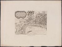
"Reproduced from the practically unique example in the library of the Society of Antiquaries.", "Walker & Boutall, ph. sc.", Alternate title: Map of London and Westminster., Bird's-eye-view., Cover tit, Includes text, index, and 2 coats of arms., and Text on cover.
Publisher:
London Topographical Society, and Printed & sould by Robt. Walton
Subject (Geographic):
London (England)--Aerial views--Early works to 1800--Facsimiles and Westminster (London, England)--Aerial views--Early works to 1800--Facsimiles
Subject (Name):
London Topographical Society and Walton, Robert, 1618-1688
Principal islands in America belonging to the English empire viz Jamaica, Barbados, Antegoa, St. Christophers & Bermudos
Description:
[Antigua and Bermuda Islands] -- A general map of the Cariby Islands -- [Saint Kitts] -- [Barbados] -- The explanation of the marks on the island of Iamaica., Bar scale given in miles., No. 62 of 69 maps bound together in composite atlas., Relief shown pictorially., and Scales differ.
Publisher:
Sold by Phillip Lea at the Atlas and Hercules in Cheapside