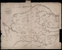
Чертезъ украинским и черкаскимъ городамъ от Москвы до Киева, и въ крымскую землу, дороги болшие, красные, черние, малшие.
Description:
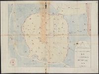
Relief shown pictorially. and Stamp: Koenigl. Kartograph. Institut, Berlin. On verso in manuscript: "Mappa Expeditionis Moscovitica Duce Galicin Aõ 1681". Piece of paper with shelf mark attached at upper edge: "Cl. N. 16 [undeciphered].
Subject (Geographic):
Kiev (Ukraine : Oblast)--Maps--Early works to 1800.
Freducci, Conte di Ottomano, active 1497-1539, cartographer
Published / Created:
[1536?]
Call Number:
Covers 49 +1536
Image Count:
6
Resource Type:
cartographic image
Description:
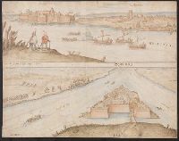
Title devised by cataloger., Pen-and-ink in black, red, blue, green, and gold., Four charts, each measuring 33 x 43 cm, mounted on composite boards and edged with vellum, bound in boards covered by blue cloth with label pasted on front cover (No. [1906/242 in manuscript])., and Inscription on third chart (Mediterranean region from the Strait of Gibraltar to the coast of Greece), "Yhs ma [ver]go Conte freducci de ancona la facta nela[n]no MCCCCCXXXVJ."
Publisher:
Conte di Ottomano Freducci
Subject (Geographic):
Mediterranean Region, North Atlantic Ocean, and Baltic Sea
Backed with paper., Coordinates not present on map and are approximated., Imperfect: chipped, with some loss of text., Manuscript number on recto: 608., and Manuscript numbers on verso: 2170.