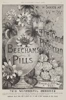
Title from item., Date and publisher from item., In upper margin: Nov. 24, 1888; The Illustrated London News; 633., This electronic record is derived from historic data and may not reflect our current information. Review and updating of records is ongoing., and Temporary local Medical Library subject terms: Patent medicines.
Publisher:
Illustrated London news
Subject (Name):
Beecham's Pills (Firm).
Subject (Topic):
Patent medicines, Vases, Flowers, and Advertisements
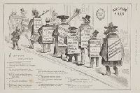
Title from item., Date and publisher from item., In left margin: May 23, 1889; The Illustrated London News; 675., and This electronic record is derived from historic data and may not reflect our current information. Review and updating of records is ongoing.
Publisher:
Illustrated London news
Subject (Name):
Beecham's Pills (Firm).
Subject (Topic):
Patent medicines, Sandwich boards, Politicians, Government officials, and Advertisements
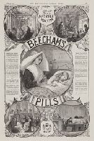
Title from item., Date and publisher from item., In upper margin: April 28, 1887; The Illustrated London News; 469., Vignettes are titled: In the palace; In the cottage; In the study; At sea., and This electronic record is derived from historic data and may not reflect our current information. Review and updating of records is ongoing.
Publisher:
Illustrated London news
Subject (Name):
Beecham's Pills (Firm).
Subject (Topic):
Patent medicines, Nurses, Children, Knitting, and Advertisements
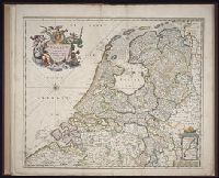
Homann Erben (Firm) Mayer, Tobias, 1723-1762 Schneider, R. A.
Published / Created:
1747 [i.e. 1748?]
Call Number:
1975 Folio 31
Collection Title:
[Atlas factice of 42 maps, produced by the Homann Erben firm]
Image Count:
1
Alternative Title:
Carte des XVII. provinces ou de l’Allemagne inferievre, dressee suivant la projection stereographique, et appueyee par les mesures faites de Mess. Cassini, Snellius et Mouschenbrok, par Mr. Tob. Majer de la Societe geographique, et publiee par les Heritiers de Homann, l’An 1748
Publisher:
Cura et Studio Homannianorum Heredum
Subject (Geographic):
Belgium --Maps --Early works to 1800, Benelux countries --Maps --Early works to 1800, Luxembourg --Maps --Early works to 1800, and Netherlands --Maps --Early works to 1800
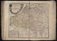
[Atlas factice of 32 maps and 1 distance table, produced by the Homann Erben firm]
Image Count:
2
Alternative Title:
Carte des XVII. provinces ou de l’Allemagne inferievre, dressee suivant la projection stereographique, et appueyee par les mesures faites de Mess. Cassini, Snellius et Mouschenbrok, par Mr. Tob. Majer de la Societe geographique, et publiee par les Heritiers de Homann, l’An 1748
Publisher:
Cura et Studio Homannianorum Heredum
Subject (Geographic):
Belgium --Maps --Early works to 1800, Benelux countries --Maps --Early works to 1800, Luxembourg --Maps --Early works to 1800, and Netherlands --Maps --Early works to 1800
[Atlas factice of 50 maps, primarily by Johann Baptist Homann and/or issued by the Homann Erben
Image Count:
1
Alternative Title:
Belgium Catholicum seu decem provinciae Germaniae inferioris and Carte des Pais Bas catholiques ou des X provinces de l’Allegmagne inferieure, etc. dessinee au juste selon les exactes observations astronomiques et operations geometriques des Messur. Cassini, Snellius, Muschenbrok, etc. dressee par Sr. Tobias Maier, mathematicien; aux depens des Heritiers de Homann
Publisher:
Edentibus Homannianis heredib
Subject (Geographic):
Belgium --Maps --Early works to 1800 and Luxembourg --Maps --Early works to 1800