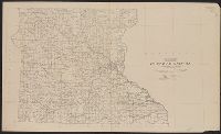
Yosemite Valley, Yosemite National Park, California
Description:
"Surveyed in 1905-1906 in cooperation with the State of California.", At head of title: Department of the Interior., Contour interval 50 feet. Datum is mean sea level., Includes location map and table of "Elevations of principal points.", and Relief shown by contours and spot heights.
Publisher:
U.S. Geological Survey,
Subject (Geographic):
Yosemite Valley (Calif.)--Maps
Subject (Name):
Douglas, Edward Morehouse, 1855-1932, Marshall, R. B. (Robert Bradford), 1867-1949, Matthes, François, 1874-1948, and Urquhart, C. F
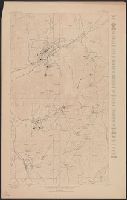
"Datum is mean sea level, based upon elevation of Oregon Short Line R.R. Station at Eureka taken as 6387 feet.", "Description of Topographic map of the United States" on verso., and "R.U. Goode, Geographer in charge. Triangulation by S.S. Gannett. Topography by W.T. Griswold and R.B. Marshall."
Publisher:
U.S. Geological Survey,
Subject (Geographic):
Juab County (Utah)--Maps and Utah County (Utah)--Maps
Subject (Name):
Gannett, Samuel S. (Samuel Stinson), 1861-1939, Goode, Richard Urquhart, 1858-1903, Griswold, W. T. (William Tudor), 1859-1931, and Marshall, R. B. (Robert Bradford), 1867-1949