Skip to search
Skip to main content
Skip to first result
Search
You Searched For
Resource Type
Maps, Atlases & Globes
Creator
Geological Survey (U.S.)
Publication Place
[Washington, D.C. :
New Search
Search Results
Creator:
Published / Created:
1905?]
Call Number:
837gce T764 1905
Container / Volume:
BRBL_00594
Image Count:
1
Resource Type:
Maps, Atlases & Globes
Description:
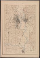
"Third annual report Reclamation Service, Pl. XXXI.", Relief shown by hachures and spot heights., and Shows irrigable lands, surveyed canal lines, and irrigation canals under construction.
Publisher:
U.S. G.P.O,
Subject (Name):
A. Hoen & Co and Geological Survey (U.S.). Reclamation Service. Annual report of the Reclamation Service
Subject (Topic):
Irrigation projects--Carson River Watershed (Nev.)--Maps, Irrigation projects--Truckee River Watershed (Calif. and Nev.)--Maps, and Irrigation--Nevada--Maps
Found in:
Beinecke Rare Book and Manuscript Library > General map of Truckee-Carson Project, Nevada / U.S. Geological Survey.
Creator:
Published / Created:
1898]
Call Number:
824cbf Om1 1898
Container / Volume:
BRBL_00571
Image Count:
1
Resource Type:
Maps, Atlases & Globes
Alternative Title:
Nebraska, Iowa.
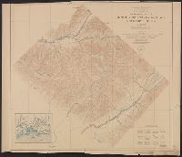
Description:
"Nebraska, Iowa"--Upper right margin., "Surveyed in 1893 and 1898.", and Relief shown by contours.
Publisher:
The Survey,
Subject (Geographic):
Omaha Region (Neb.)--Maps
Subject (Name):
Gannett, Henry, 1846-1914, Hawkins, George T., 1863-1938, Renshawe, John H, Walcott, Charles D. (Charles Doolittle), 1850-1927, and Wallace, H. S
Found in:
Beinecke Rare Book and Manuscript Library > Omaha and vicinity / U.S. Geological Survey ; Charles D. Walcott, director ; Henry Gannett, chief topographer ; Jno. H. Renshawe, topographer in charge ; control by Geo. T. Hawkins ; Mo. river from surveys by Mo. Riv. Com. ; topography by H.S. Wallace.
Creator:
Published / Created:
1922
Call Number:
848 K84 1922
Container / Volume:
BRBL_00633
Image Count:
1
Resource Type:
Maps, Atlases & Globes
Description:
"Alaska sheet no. 601 C.", "Survey in 1912-1913.", Includes location map., and Relief shown by contours and spot heights.
Publisher:
U.S. Geological Survey,
Subject (Topic):
Cordova-McCarthy Division (Alaska)--Maps
Found in:
Beinecke Rare Book and Manuscript Library > Topographic map of Kotsina-Kuskulana District, Copper River region, Alaska.
Branch:v1.61.6 ,Deployed:2024-06-12T09:55:19-04:00