Skip to search
Skip to main content
Skip to first result
Search
You Searched For
Date
Unknown
Resource Type
Maps, Atlases & Globes
Language
Italian
Date Created
[Missing]
New Search
Search Results
Call Number:
40 F41 1840
Container / Volume:
BRBL_00207
Image Count:
1
Resource Type:
Maps, Atlases & Globes
Alternative Title:
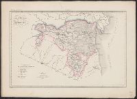
Atlante geografico dell'Italia.
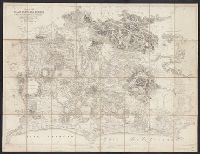
Description:
"Atlante geografico dell'Italia ; Stato Pontificio ; N. 3"--At top of map sheet. and Hand colored.
Subject (Geographic):
Ferrara (Italy)--Maps and Papal States--Maps
Subject (Name):
Manzoni, P, Stanghi, V, and Vallardi, Francesco
Found in:
Beinecke Rare Book and Manuscript Library > Legazione di Ferrara / V. Stanghi inc. ; P. Manzoni scrisse.
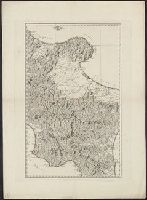
Call Number:
40 1840A 2
Container / Volume:
BRBL_00200
Image Count:
1
Resource Type:
Maps, Atlases & Globes
Description:
"N. 72"--Above upper right corner., Karpinski-von Wieser Map Collection--Stamp., Relief shown pictorially., and Title devised by cataloger.
Subject (Geographic):
Italy, Southern--Maps
Subject (Name):
Reilly, Franz J. J. von
Found in:
Beinecke Rare Book and Manuscript Library > Map of part of southern Italy.
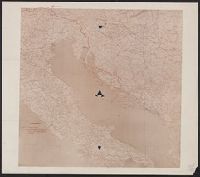
Call Number:
11hcf 1919-53
Container / Volume:
BRBL_00010L
Image Count:
1
Resource Type:
Maps, Atlases & Globes
Description:
"Leggenda, Rivendicazioni Italiane [shown in solid red line], Confine amministrativo della Dalmazia oltre la zona limitata dal Patto di Londres [shown in dotted blue line].", Coordinates not present on map and are approximated., and Imperfect: torn along fold i
Subject (Geographic):
Adriatic Sea--Maps
Subject (Topic):
Treaty of London--(1915), World War, 1914-1918--Diplomatic history, World War, 1914-1918--Territorial que, World War, 1914-1918--Territorial questions--Croatia, and World War, 1914-1918--Territorial questions--Italy
Found in:
Beinecke Rare Book and Manuscript Library > Map of the Adriatic Sea and surrounding countries showing territorial demarcations based on Treaty of London, 1915.
Call Number:
402eb 1836
Container / Volume:
BRBL_00233A
Image Count:
1
Resource Type:
Maps, Atlases & Globes
Description:
"Redatta a corredo del primo volume pag. 29."
Subject (Geographic):
Lombardy (Italy)--Maps and Lombardy (Italy)--Population--Maps
Subject (Topic):
Population density--Italy--Lombardy--Maps
Found in:
Beinecke Rare Book and Manuscript Library > Mappa di popolazione della Lombardia ...
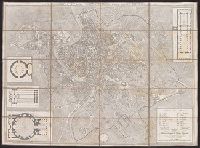
Call Number:
40 R66 1820
Container / Volume:
BRBL_00216
Image Count:
1
Resource Type:
Maps, Atlases & Globes
Alternative Title:
Pianta topografica di Roma moderna, estratta dalla grande del Nolli, an. 1822
Description:
"Ano. 1820"--Lower right corner., 4 insets., and Dissected and mounted on linen. Bookseller's label on verso.
Subject (Geographic):
Rome (Italy)--Maps
Subject (Name):
Monaldini, Venanzio and Ruga, Pietro
Found in:
Beinecke Rare Book and Manuscript Library > Nuova pianta di Roma moderna, estratta dalla grande del Nolli : corretta ed accresciuta de nomi delle contrade indicati al loro rispettivo sito / Pietro Ruga, incise.
Creator:
Call Number:
39hc H79 1810
Container / Volume:
BRBL_00192
Image Count:
1
Resource Type:
Maps, Atlases & Globes
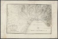
Description:
"Tav. X"--Upper right margin. and Relief shown by contours.
Subject (Geographic):
Hostalric (Spain)--History, Military--19th century--Maps and Hostalric (Spain)--Maps
Subject (Topic):
Peninsular War, 1807-1814--Maps
Found in:
Beinecke Rare Book and Manuscript Library > Piano del forte di Hostalrich colle opere del Blocco eseguite nel 1810 ... / C. Vacani, disegno ; L. Antonini, incise.
Creator:
Call Number:
39hc G31 1809
Container / Volume:
BRBL_00192
Image Count:
1
Resource Type:
Maps, Atlases & Globes
Description:
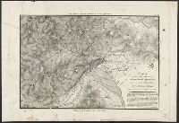
"Tav. IX"--Upper right margin. and Relief shown by contours.
Subject (Geographic):
Gerona (Spain)--History--Siege, 1808-1809--Maps and Gerona (Spain)--Maps
Subject (Topic):
Peninsular War, 1807-1814--Maps
Found in:
Beinecke Rare Book and Manuscript Library > Piano della città di Gerona colle opere d'assedio eseguite nel 1809 ... / C. Vacani, disegno ; L. Antonini, incise.
Creator:
Call Number:
39hc Z19 1809
Container / Volume:
BRBL_00192
Image Count:
1
Resource Type:
Maps, Atlases & Globes
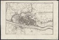
Description:
"Tav. VIII"--Upper right margin.
Subject (Geographic):
Zaragoza (Spain)--History--Siege, 1808-1809--Maps and Zaragoza (Spain)--Maps
Subject (Topic):
Peninsular War, 1807-1814--Maps
Found in:
Beinecke Rare Book and Manuscript Library > Piano della città di Zaragoza colle opere d'assedio eseguite nel 1809 ... / C. Vacani, disegno ; L. Antonini, incise.
Creator:
Call Number:
39hc R71 1808
Container / Volume:
BRBL_00192
Image Count:
1
Resource Type:
Maps, Atlases & Globes
Description:
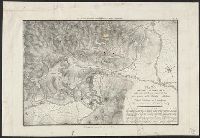
"Tav. VII"--Upper right margin. and Relief shown by contours.
Subject (Geographic):
Rosas (Spain)--History, Military--19th century--Maps and Rosas (Spain)--Maps
Subject (Topic):
Peninsular War, 1807-1814--Maps
Found in:
Beinecke Rare Book and Manuscript Library > Piano della fortezza di Rosas colle opere d'assedio eseguite nel 1808 ... / C. Vacani, disegno ; L. Antonini, incise.
Call Number:
406 1855
Container / Volume:
BRBL_00236
Image Count:
1
Resource Type:
Maps, Atlases & Globes
Description:
Dissected and mounted on linen., Oriented with north to the upper left., Prime meridian: Rome., and Relief shown by hachures.
Subject (Geographic):
Italy--Lazio and Lazio (Italy)--Maps.
Found in:
Beinecke Rare Book and Manuscript Library > Pianta Della Campagna Romana Nello Stato Antico e Moderno / To the Right Hon'ble Lord George John Warren Vernon ... this plate is respectfully dedicated by His Lordship's most obed't serv't Luigi Piale ; Domenico Feltrini scrisse ; Augusto Fornari incise,
Branch:v1.61.8 ,Deployed:2024-06-20T11:15:04-04:00