Skip to search
Skip to main content
Skip to first result
Search
You Searched For
Extent of Digitization
Completely digitized
Genre
Atlases
Genre
Maps
New Search
Search Results
Creator:
Published / Created:
1715?
Call Number:
1973 Folio 30
Collection Title:
[Atlas factice of 32 maps and 1 distance table, produced by the Homann Erben firm]
Image Count:
2
Publisher:
[Johann Baptist Homann]
Subject (Geographic):
Saxony (Germany) --Maps --Early works to 1800
Subject (Topic):
Atlases, German --Early works to 1800
Collection Created:
[Nuremberg : s.n., 1701-1760]
Found in:
Beinecke Rare Book and Manuscript Library > Circulus Saxoniae inferioris in omnes suos status et principatus / [cartographic material] / accurate divisus ex conatibus Io. Bapt. Homanni
Creator:
Published / Created:
1750
Call Number:
1973 Folio 30
Collection Title:
[Atlas factice of 32 maps and 1 distance table, produced by the Homann Erben firm]
Image Count:
2
Publisher:
[Matthaeus Seutter?]
Subject (Geographic):
Nordhausen (Germany : Landkreis) --Maps --Early works to 1800
Subject (Topic):
Atlases, German --Early works to 1800
Collection Created:
[Nuremberg : s.n., 1701-1760]
Found in:
Beinecke Rare Book and Manuscript Library > Comitatus Stolbergensis delineatio geographia, Praefecturas Hohnstein, Stolberg, Hayn Berenroda, Ebersburg, Ufftrungen, Rosla et Questen cum limitibus et vicinia accurate exhibens / [cartographic material] / caelo Matthaei Seutteri. Georgraphi Caesarei ;
Creator:
Published / Created:
a. 1760
Call Number:
1973 Folio 30
Collection Title:
[Atlas factice of 32 maps and 1 distance table, produced by the Homann Erben firm]
Image Count:
2
Alternative Title:
Comitatus Schoenburgensis
Publisher:
Edentibus Homannianis Heredibus
Subject (Geographic):
Zwickau (Germany : Landkreis) --Maps --Early works to 1800
Subject (Topic):
Atlases, German --Early works to 1800
Collection Created:
[Nuremberg : s.n.,
Found in:
Beinecke Rare Book and Manuscript Library > Comitatvs Schoenburgensis [cartographic material] : in quo celsissimorum comitum de Schoenburg regiones ad circulum Saxoniae superiorem Imperii Romano-Germanici pertinentes et in Marchionatu Misniae sitae, subfeuda porro Bohemico-Imperialia, nempe Dynasti
Creator:
Published / Created:
1750
Call Number:
1973 Folio 30
Collection Title:
[Atlas factice of 32 maps and 1 distance table, produced by the Homann Erben firm]
Image Count:
2
Publisher:
[Matthaeus Seutter?]
Subject (Geographic):
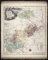
Saxony-Anhalt (Germany) --Maps --Early works to 1800
Subject (Topic):
Atlases, German --Early works to 1800
Collection Created:
[Nuremberg : s.n., 1701-1760]
Found in:
Beinecke Rare Book and Manuscript Library > Delineatio geographica comitatus Mansfeldensis ad jurisdictionem tum Saxonicam tum Brandenburgicam spectans, cum praefectura Sangerhusana, Querfurtensi, Sittenbacensi, Allstaedensi, et loci finitimis / [cartographic material] / cura Matth. Seutteri, Geogr
Creator:
Published / Created:
ca. 1757
Call Number:
1973 Folio 30
Collection Title:
[Atlas factice of 32 maps and 1 distance table, produced by the Homann Erben firm]
Image Count:
2
Publisher:
[Tobias Conrad Lotter?]
Subject (Geographic):
Greiz (Germany : Landkreis) --Maps --Early works to 1800
Subject (Topic):
Atlases, German --Early works to 1800
Collection Created:
[Nuremberg : s.n.,
Found in:
Beinecke Rare Book and Manuscript Library > Delineatio geographica specialis territorii celsissimorum S.R.I. comitum Ruthenorum de Plauia [cartographic material] : utriusque linea senioris et iunioris partem Vogtlandiae / opera et studio Ioh. Gottlieb Schulzii, S.C.M. Ingen. Lieut. ; accurate edita
Creator:
Published / Created:
1720?
Call Number:
1975 Folio 31
Collection Title:
[Atlas factice of 42 maps, produced by the Homann Erben firm]
Image Count:
1
Publisher:
Johann Baptist Homann
Subject (Geographic):
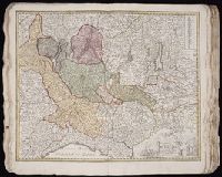
Italy, Northern --Maps --Early works to 1800 and Veneto (Italy) --Maps --Early works to 1800
Subject (Topic):
Atlases, German --Early works to 1800
Collection Created:
[Nuremberg,
Found in:
Beinecke Rare Book and Manuscript Library > Dominii Veneti cum vicinis Parmae, Mutinae, Mantuae, et Mirandolae statibus nova descriptio / [cartographic material] / edita a Ioh. Baptista Homanno, sacrae caes. majestatis geographo
Creator:
Published / Created:
1758
Call Number:
1973 Folio 30
Collection Title:
[Atlas factice of 32 maps and 1 distance table, produced by the Homann Erben firm]
Image Count:
2
Publisher:
[Tobias Conrad Lotter]
Subject (Geographic):
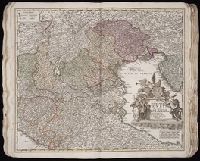
Halle (Germany : Regierungsbezirk) --Maps --Early works to 1800 and Magdeburg (Germany : Regierungsbezirk) --Maps --Early works to 1800
Subject (Topic):
Atlases, German --Early works to 1800
Collection Created:
[Nuremberg : s.n., 1701-1760]
Found in:
Beinecke Rare Book and Manuscript Library > Ducatus Magdeburgensis et Halensis cum finitimis delineation geographica / [cartographic material] / curante Matthaeo Seuttero, Geographo. Caeser
Creator:
Published / Created:
1730?
Call Number:
1975 Folio 31
Collection Title:
[Atlas factice of 42 maps, produced by the Homann Erben firm]
Image Count:
1
Publisher:
Homann
Subject (Geographic):
Milan (Italy : Province) --Maps --Early works to 1800
Subject (Topic):
Atlases, German --Early works to 1800
Collection Created:
[Nuremberg,
Found in:
Beinecke Rare Book and Manuscript Library > Ducatus Mediolani una cum confinyes accurata tabula / [cartographic material] / exhibitus auctus et eme[n]datus per Ioh. Bapt. Homannum
Creator:
Published / Created:
[ca. 1696]
Call Number:
1973 Folio 10
Image Count:
1
Resource Type:
Maps, Atlases & Globes
Description:
Bar scales in Milliaria Germanica Communia and Milliaria Gallica Communia., Ferro meridian., No. 37 of 69 maps bound together in composite atlas., Relief shown pictorially., and Scale [ca. 1:775 000].
Publisher:
[Frederik de Wit]
Subject (Geographic):
Prussia, east (Poland and Russia) --Maps --Early works to 1800
Found in:
Beinecke Rare Book and Manuscript Library > Ducatus Prussiae tam Polono Regiae quam Brandenburgo Ducalis : correcta descriptio et divisio Regiae scilicet in tres Palatinatus, et Ducalis in totidem circulos, cum utrius[que] subdivisione in tractus minores
Creator:
Published / Created:
1730
Call Number:
1975 Folio 31
Collection Title:
[Atlas factice of 42 maps, produced by the Homann Erben firm]
Image Count:
1
Alternative Title:
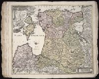
Ducatuum Livoniae et Curlandiae cum vicinis insulis
Publisher:
Johann Baptist Homann
Subject (Geographic):
Estonia --Maps --Early works to 1800 and Latvia --Maps --Early works to 1800
Subject (Topic):
Atlases, German --Early works to 1800
Collection Created:
[Nuremberg,
Found in:
Beinecke Rare Book and Manuscript Library > Ducatvvm Livoniae et Cvrlandiae cum vicinis insulis [cartographic material] : nova exhibitio geographica / editore Ioh. Baptista Homanno
Branch:v1.61.6 ,Deployed:2024-06-12T09:55:31-04:00