Froschauer, Christoph, d. 1564, printer Stumpf, Johannes, 1500-1576?
Published / Created:
[ca. 1556?]
Call Number:
1983 Folio 19
Collection Title:
[Atlas factice of 96 maps by Blaeu, Visscher, Jansson, Hondius and others]
Image Count:
1
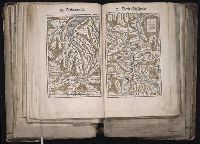
Description:
Each map hand col. Sheet measures 39 x 47.7 cm. Reinforced along edges with manuscript waste. No. 48 of 92 maps bound together.
Publisher:
Christoffel Froschauer
Subject (Geographic):
Graubunden (Switzerland)--Maps--Early works to 1800, Rhaetian Alps--Maps--Early works to 1800, Switzerland--Maps--Early works to 1800, and Ticino (Switzerland) --Maps--Early works to 1800
[Atlas factice of 96 maps by Blaeu, Visscher, Jansson, Hondius and others]
Image Count:
1
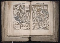
Description:
Each map hand col. Sheet measures 38.8 x 48 cm. Reinforced along edges with manuscript waste. No. 46 of 92 maps bound together. and Numbered 50 on verso.
Publisher:
Christoffel Froschauer
Subject (Geographic):
Zurich (Switzerland : Canton) --Maps --Early works to 1800
Froschauer, Christoph, d. 1564, printer Stumpf, Johannes, 1500-1576?
Published / Created:
[ca. 1556?]
Call Number:
1983 Folio 19
Collection Title:
[Atlas factice of 96 maps by Blaeu, Visscher, Jansson, Hondius and others]
Image Count:
1
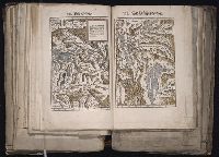
Description:
Each map hand col. Sheet measures 38.5 x 47.9 cm. Reinforced along edges with manuscript waste. No. 47 of 92 maps bound together. and Numbered 51 on verso.
Froschauer, Christoph, d. 1564, printer Stumpf, Johannes, 1500-1576?
Published / Created:
[ca. 1556?]
Call Number:
1983 Folio 19
Collection Title:
[Atlas factice of 96 maps by Blaeu, Visscher, Jansson, Hondius and others]
Image Count:
1
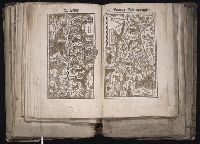
Description:
Each map hand col. Sheet measures 38.8 x 47.5 cm. Reinforced along edges with manuscript waste. No. 49 of 92 maps bound together. and Numbered 52 on verso.
Publisher:
Christoffel Froschauer
Subject (Geographic):
Basel (Canton) (Switzerland) --Maps--Early works to 1800 and Valais (Switzerland)--Maps--Early works to 1800