Skip to search
Skip to main content
Skip to first result
Search
You Searched For
Genre
Atlases
Genre
Engravings
Language
Latin
New Search
Search Results
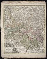
Creator:
Published / Created:
ca. 1715
Call Number:
1975 Folio 31
Collection Title:
[Atlas factice of 42 maps, produced by the Homann Erben firm]
Image Count:
1
Alternative Title:
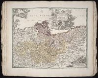
Circulus Rhenanus inferior
Publisher:
Johann Baptist Homann
Subject (Geographic):
Rhine River Valley --Maps --Early works to 1800
Subject (Topic):
Atlases, German --Early works to 1800
Collection Created:
[Nuremberg,
Found in:
Beinecke Rare Book and Manuscript Library > S.R.I. circulus Rhenanus inferior sive electorum Rheni [cartographic material] : complectens tres archiepiscopatus, Moguntinum, Coloniensem et Trevirensem, Palatinatum Rheni, Comit. Beilstein, Newenaer, Inf. Isenburg; et Reiferscheit / repraesentatus a Io
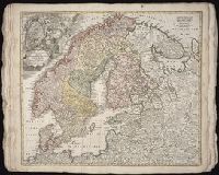
Creator:
Published / Created:
ca. 1715
Call Number:
1975 Folio 31
Collection Title:
[Atlas factice of 42 maps, produced by the Homann Erben firm]
Image Count:
1
Publisher:
Johann Baptist Homann
Subject (Geographic):
Scandinavia --Maps --Early works to 1800
Subject (Topic):
Atlases, German --Early works to 1800
Collection Created:
[Nuremberg,
Found in:
Beinecke Rare Book and Manuscript Library > Scandinavia [cartographic material] : complectens Sueciae, Daniae & Norvegiae Regna. / ex tabulis Ioh. Baptistae Homanni
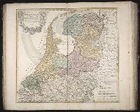
Creator:
Published / Created:
a. 1748
Call Number:
1973 Folio 30
Collection Title:
[Atlas factice of 32 maps and 1 distance table, produced by the Homann Erben firm]
Image Count:
2
Alternative Title:
Septem provinciae seu Belgium Foederatum quod generaliter Hollandia
Publisher:
Edentibus Homannianis Heredibus
Subject (Geographic):
Netherlands --Maps --Early works to 1800
Subject (Topic):
Atlases, German --Early works to 1800
Collection Created:
[Nuremberg : s.n., 1701-1760]
Found in:
Beinecke Rare Book and Manuscript Library > Septem provinciae seu Belgivm Foederatvm quod generaliter Hollandia [cartographic material] : audit speciali mappa delineatum adhibitis auxilium observationibus astronomieis nec non mensurationibus Snellii, Muschenbrokii, etc. / auctore Tobia Mayero ...
Creator:
Published / Created:
[ca. 1680]
Call Number:
1973 Folio 10
Image Count:
1
Resource Type:
Maps, Atlases & Globes
Description:
Bar scales in Milliaria Germanica communia 15 in uno gradu, Milliaria Gallica magna, sive horae itineris, and milliaria Italica magna 60 in uno gradu., No. 19 of 69 maps bound together in composite atlas., Relief shown pictorially., and Scale [ca. 1:860 000].
Publisher:
[Frederik de Wit?]
Subject (Geographic):
Tuscany (Grand Duchy) --Maps --Early works to 1800
Found in:
Beinecke Rare Book and Manuscript Library > Status ecclesiasticus et magnus ducatus Thoscanae
Creator:
Published / Created:
1748
Call Number:
1975 Folio 31
Collection Title:
[Atlas factice of 42 maps, produced by the Homann Erben firm]
Image Count:
1
Alternative Title:
Etats de l’Eglise & du Grand Duche de Toscane, Etats de l’Eglise & du Grand Dvche de Toscane, and Status Ecclesiastici nec non Magni Ducatus Toscanae nova tabula geographica
Publisher:
Curantibus Homannianis Heredibus
Subject (Geographic):
Papal States --Maps --Early works to 1800 and Tuscany (Italy) --Maps --Early works to 1800
Subject (Topic):
Atlases, German --Early works to 1800
Collection Created:
[Nuremberg,
Found in:
Beinecke Rare Book and Manuscript Library > Statvs Ecclesiastici nec non Magni Ducatvs Toscanae nova tabula geographica [cartographic material] / secundum prinicipia legitimae delineationis descripta a Tob. Majero, Societ. Geogr. Sodali
Creator:
Published / Created:
[ca. 1657?]
Call Number:
1973 Folio 10
Image Count:
1
Resource Type:
Maps, Atlases & Globes
Description:
Bar scales given in milliaria Germanica communia and milliaria Gallica communia., Ferro meridian., No. 54 of 69 maps bound together in composite atlas., Relief shown pictorially., and Scale [ca 1:1 330 000].
Publisher:
Sumptibus Ioannes Ianssonii
Subject (Geographic):
Syria --Maps --Early works to 1800
Found in:
Beinecke Rare Book and Manuscript Library > Syriae sive Soriae : nova et accurata descriptio
Creator:
Published / Created:
[1662]
Call Number:
1973 Folio 10
Image Count:
1
Resource Type:
Maps, Atlases & Globes
Description:
Ferro meridian., No. 52 of 69 maps bound together in composite atlas., Relief shown pictorially., and Scale [ca. 1:13 750 000].
Subject (Geographic):
South Asia --Maps --Early works to 1800 and Southeast Asia --Maps --Early works to 1800
Found in:
Beinecke Rare Book and Manuscript Library > Tabula Indiae orientalis
Creator:
Published / Created:
[169-?]
Call Number:
1973 Folio 10
Image Count:
1
Resource Type:
Maps, Atlases & Globes
Description:
Bar scales in Mill. Germanica Comm 15 in uno gradu and Mill. Gallica et Livonica quae horae itineris., Ferro meridian., No. 38 of 69 maps bound together in composite atlas., Relief shown pictorially., and Scale [ca. 1:910 000].
Subject (Geographic):
Estonia --Maps --Early works to 1800 and Latvia --Maps --Early works to 1800
Found in:
Beinecke Rare Book and Manuscript Library > Tabula ducatuum Livoniae et Curlandiae: recentior incisa editaque
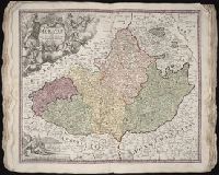
Creator:
Published / Created:
ca. 1715
Call Number:
1975 Folio 31
Collection Title:
[Atlas factice of 42 maps, produced by the Homann Erben firm]
Image Count:
1
Publisher:
Johann Baptist Homann
Subject (Geographic):
Moravia (Czech Republic) --Maps --Early works to 1800
Subject (Topic):
Atlases, German --Early works to 1800
Collection Created:
[Nuremberg,
Found in:
Beinecke Rare Book and Manuscript Library > Tabula generalis Marchionatus Moraviae in sex circulos divisae [cartographic material] : quos mandato Caesareo accurate emensus / hac mappa delineatos exhibet Ioh. Christoph. Mueller, S.C.M. Capitan ; editore Joh. Bapt. Homanno
Creator:
Published / Created:
ca. 1715
Call Number:
1975 Folio 31
Collection Title:
[Atlas factice of 42 maps, produced by the Homann Erben firm]
Image Count:
1
Alternative Title:
Tabula marchionatus Brandenburgici et ducatus Pomeraniae
Publisher:
Johann Baptist Homann
Subject (Geographic):
Brandenburg (Germany) --Maps --Early works to 1800 and Pomerania (Poland and Germany) --Maps --Early works to 1800
Subject (Topic):
Atlases, German --Early works to 1800
Collection Created:
[Nuremberg,
Found in:
Beinecke Rare Book and Manuscript Library > Tabvla marchionatvs Brandenbvrgici et dvcatvs Pomeraniae [cartographic material] : quae sunt pars septentrionalis circuli Saxoniae superioris / novissime edita a Ioh. Baptista Homanno
Branch:v1.61.8 ,Deployed:2024-06-20T11:14:46-04:00