Skip to search
Skip to main content
Skip to first result
Search
You Searched For
Genre
Engravings
Genre
Hand coloring
Language
Latin
New Search
Search Results
Creator:
Published / Created:
[ca. 1715]
Call Number:
1983 Folio 23
Collection Title:
[Atlas factice of 50 maps, primarily by Johann Baptist Homann and/or issued by the Homann Erben
Image Count:
1
Publisher:
[Johann Baptist Homann]
Subject (Geographic):
Carniola (Slovenia) --Maps --Early works to 1800, Croatia --Maps --Early works to 1800, and Ljubljana (Slovenia) --Maps, Pictorial --Early works to 1800
Collection Created:
[Nuremberg : Homann Erben, 1710-1786]
Found in:
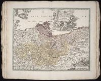
Beinecke Rare Book and Manuscript Library > Tabula Ducatus Carnioliae, vindorum Marchiae et Histriae et mente Mustr. quondam J.B. Valvasorii / concinnatia et exhibita a Io. Bapt. Homanno, S.C.M. Geogr
Creator:
Published / Created:
[1662]
Call Number:
1973 Folio 10
Image Count:
1
Resource Type:
Maps, Atlases & Globes
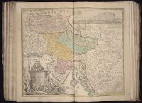
Description:
Ferro meridian., No. 52 of 69 maps bound together in composite atlas., Relief shown pictorially., and Scale [ca. 1:13 750 000].
Subject (Geographic):
South Asia --Maps --Early works to 1800 and Southeast Asia --Maps --Early works to 1800
Found in:
Beinecke Rare Book and Manuscript Library > Tabula Indiae orientalis
Creator:
Published / Created:
ca. 1684
Call Number:
Folio 469
Collection Title:
[Atlas factice of 13 maps by Nicolaes Visscher I, Nicolaes Visscher II, Guillaume Sanson, and
Image Count:
1
Publisher:
Nicolaes Visscher
Subject (Geographic):
Brabant (Belgium) --Maps --Early works to 1800 and Europe --Maps --Early works to 1800
Subject (Topic):
Atlases, Dutch --Early works to 1800
Found in:
Beinecke Rare Book and Manuscript Library > Tabula ducatus Brabantiae continens Marchionatum sacri imperii et dominium Mechliniense / [cartographic material] / de novo accurate emendata et in lucem edita per Nicolaum Visscher
Creator:
Published / Created:
[169-?]
Call Number:
1973 Folio 10
Image Count:
1
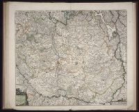
Resource Type:
Maps, Atlases & Globes
Description:
Bar scales in Mill. Germanica Comm 15 in uno gradu and Mill. Gallica et Livonica quae horae itineris., Ferro meridian., No. 38 of 69 maps bound together in composite atlas., Relief shown pictorially., and Scale [ca. 1:910 000].
Subject (Geographic):
Estonia --Maps --Early works to 1800 and Latvia --Maps --Early works to 1800
Found in:
Beinecke Rare Book and Manuscript Library > Tabula ducatuum Livoniae et Curlandiae: recentior incisa editaque
Creator:
Published / Created:
ca. 1715
Call Number:
1975 Folio 31
Collection Title:
[Atlas factice of 42 maps, produced by the Homann Erben firm]
Image Count:
1
Publisher:
Johann Baptist Homann
Subject (Geographic):
Moravia (Czech Republic) --Maps --Early works to 1800
Subject (Topic):
Atlases, German --Early works to 1800
Collection Created:
[Nuremberg,
Found in:
Beinecke Rare Book and Manuscript Library > Tabula generalis Marchionatus Moraviae in sex circulos divisae [cartographic material] : quos mandato Caesareo accurate emensus / hac mappa delineatos exhibet Ioh. Christoph. Mueller, S.C.M. Capitan ; editore Joh. Bapt. Homanno
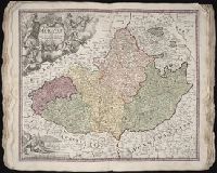
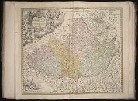
Creator:
Published / Created:
[ca. 1715]
Call Number:
1983 Folio 23
Collection Title:
[Atlas factice of 50 maps, primarily by Johann Baptist Homann and/or issued by the Homann Erben
Image Count:
1
Publisher:
[Johann Baptist Homann]
Subject (Geographic):
Moravia (Czech Republic) --Maps --Early works to 1800
Collection Created:
[Nuremberg : Homann Erben, 1710-1786]
Found in:
Beinecke Rare Book and Manuscript Library > Tabula generalis Marchionatus Moraviae in sex circulos divisae [cartographic material] : quos mandato Caesareo accurate emensus / hac mappa delineatos exhibet Ioh. Christoph. Muå¬ller, S.C.M. Capitan ; editore Joh. Bapt. Homanno
Creator:
Published / Created:
1775
Call Number:
1983 Folio 23
Collection Title:
[Atlas factice of 50 maps, primarily by Johann Baptist Homann and/or issued by the Homann Erben
Image Count:
1
Publisher:
Impensis Homannianorum Haeredum
Subject (Geographic):
Prussia, east (Poland and Russia) --Maps --Early works to 1800
Collection Created:
[Nuremberg : Homann Erben, 1710-1786]
Found in:
Beinecke Rare Book and Manuscript Library > Tabula regni Borussiae, Borussiam orientalem exhibens [cartographic material] / F.L. Guessefeld, C. P. S. C. M
Creator:
Published / Created:
ca. 1715
Call Number:
1975 Folio 31
Collection Title:
[Atlas factice of 42 maps, produced by the Homann Erben firm]
Image Count:
1
Alternative Title:
Tabula marchionatus Brandenburgici et ducatus Pomeraniae
Publisher:
Johann Baptist Homann
Subject (Geographic):
Brandenburg (Germany) --Maps --Early works to 1800 and Pomerania (Poland and Germany) --Maps --Early works to 1800
Subject (Topic):
Atlases, German --Early works to 1800
Collection Created:
[Nuremberg,
Found in:
Beinecke Rare Book and Manuscript Library > Tabvla marchionatvs Brandenbvrgici et dvcatvs Pomeraniae [cartographic material] : quae sunt pars septentrionalis circuli Saxoniae superioris / novissime edita a Ioh. Baptista Homanno
Call Number:
1977 Folio 112
Collection Title:
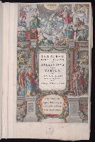
Theatrvm orbis terrarvm, sive, Atlas novvs : in quo tabvlae et descriptiones omnium regionum
Image Count:
1
Resource Type:
Books, Journals & Pamphlets
Alternative Title:
Theatrum orbis terrarum, sive, Atlas novus : in quo tabulae et descriptiones omnium regionum
Description:
Yale proprietary stamp on verso.
Subject (Name):
Blaeu, Joan, 1596-1673
Subject (Topic):
Atlases --Early works to 1800
Collection Created:
Amsterdami, apud Iohannem et Cornelium Blaeu, 1640
Found in:
Beinecke Rare Book and Manuscript Library > Theatrvm orbis terrarvm, sive, Atlas novvs : in quo tabvlae et descriptiones omnium regionum
Creator:
Published / Created:
1766
Call Number:
1983 Folio 23
Collection Title:
[Atlas factice of 50 maps, primarily by Johann Baptist Homann and/or issued by the Homann Erben
Image Count:
1
Alternative Title:
Cours de Danube
Publisher:
Cura Homannianorum Heredum, C.P.S.C.M
Subject (Geographic):
Balkan Peninsula --Maps --Early works to 1800, Danube River Valley --Maps --Early works to 1800, Europe, Central --Maps --Early works to 1800, and Europe, Southern --Maps --Early works to 1800
Collection Created:
[Nuremberg : Homann Erben, 1710-1786]
Found in:
Beinecke Rare Book and Manuscript Library > Totius Danubii cum adjacentibus regnis nec non totius Graeciae et archipelagi [cartographic material] : novissima tabula ex recentissimis subsidiis concinnata et ad leges projectionis stereographicae legitimae / reducta ab Augusto Gottlob Boehmio ...
Branch:v1.61.6 ,Deployed:2024-06-12T09:55:36-04:00