Appears in Wit's Atlas major., Includes coats of arms., No. 22 of 69 maps bound together in composite atlas., Relief shown pictorially., and Scale [ca. 1:1 100 000].
Publisher:
[Frederik de Wit]
Subject (Geographic):
Italy, Southern --Maps --Early works to 1800 and Naples (Kingdom) --Maps --Early works to 1800
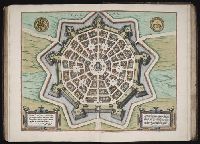
Bar scales in Milliaria Germanica communia 15 in uno gradu, Milliaria Gallica magna, sive horae itineris, and milliaria Italica magna 60 in uno gradu., No. 19 of 69 maps bound together in composite atlas., Relief shown pictorially., and Scale [ca. 1:860 000].
Publisher:
[Frederik de Wit?]
Subject (Geographic):
Tuscany (Grand Duchy) --Maps --Early works to 1800
Bar scales given in milliaria Germanica communia and milliaria Gallica communia., Ferro meridian., No. 54 of 69 maps bound together in composite atlas., Relief shown pictorially., and Scale [ca 1:1 330 000].
Bar scales in Mill. Germanica Comm 15 in uno gradu and Mill. Gallica et Livonica quae horae itineris., Ferro meridian., No. 38 of 69 maps bound together in composite atlas., Relief shown pictorially., and Scale [ca. 1:910 000].
Subject (Geographic):
Estonia --Maps --Early works to 1800 and Latvia --Maps --Early works to 1800
Blaeu, Joan, 1596-1673. Theatrum orbis terrarum Blaeu, Willem Janszoon, 1571-1638 Blaeu, Willem Janszoon, 1571-1638. Theatrum orbis terrarum
Published / Created:
[ca. 163-?]
Call Number:
1983 Folio 19
Collection Title:
[Atlas factice of 96 maps by Blaeu, Visscher, Jansson, Hondius and others]
Image Count:
2
Resource Type:
Maps, Atlases & Globes
Alternative Title:
Imperium Turcicum in Europa, Asia et Africa regiones proprias, tributar, et clientelares exhibens and Turcicum imperium
Description:
Imperfect: torn and mutilated along fold and edges, partially repaired, with some loss of text; cartouche cut-out and replicated in ms. with new title.
All volumes bound to match 1973 Folio 72. Factitious collection of about 549 maps taken from the atlases of the 17th and the beginning of the 18th cent., put together with the title "Atlas" and bound in 6 volumes. These volumes originally bore the imprint: Amstelaedamii apvd Reiniervm & Josvam Ottens. Over these words on the title-pages of v. 1-2, 4-6 is the name of Henrik de Leth who painted them. Volume 3 has only the erased imprint of Ottens., For fuller description see Phillips 3448 and C. Koeman's Atlantes Neerlandici, bibliography of terrestrial, maritime and celestial atlases and pilot books, published in the Netherlands up to 1800, Amsterdam c1967-71, v. 2, p. 63-83., and Maps by P. Schenck and son, G. Valck, F. de Wit, N. Visscher and others.
Publisher:
chez J. Covens & C. Mortier,
Subject (Geographic):
Denmark --Maps --Early works to 1800
Subject (Name):
Reiner et Josua Ottens (Firm), Schenk, Peter, 1660-1718 or 1719., and Valck, G. (Gerard), 1651 or 1652-1726.