"Though the map ... has an 1840 date, it appears from a letter of J.H. Overton, United States Commissioner, dated Opelousas, Louisiana, August 10, 1841 ... and the reply of October 1, 1841 ... that the maps ... had not been forwarded at that time. However, they had been received by January 15, 1842 ..and that they were issued by March 17, 1842, is shown by the reprintings of them accompanying the President's message of that date"--Streeter, Bibliographof Texas, 1438., At head of title: A.2., From the Streeter collection., Relief shown by hachures., and Three parallel sections of 12 miles each.
Publisher:
s.n.,
Subject (Geographic):
Texas--Boundaries--United States--Maps and United States--Boundaries--Texas--Maps
Subject (Name):
Streeter, Thomas W.--(Thomas Winthrop),--1883-1965--Ownership
Part of the boundary between the United States and Texas, north of Sabine River from the 36th to the 72nd mile mound
Description:
"Though the map ... has an 1840 date, it appears from a letter of J.H. Overton, United States Commissioner, dated Opelousas, Louisiana, August 10, 1841 ... and the reply of October 1, 1841 ... that the maps ... had not been forwarded at that time. However, they had been received by January 15, 1842 ... and that they were issued by March 17, 1842, is shown by the reprintings of them accompanying the President's message of that date"--Streeter, T.W. Bibliography of Texas, 1438., At head of title: B.2., From the Streeter collection., Relief shown by hachures., and Three parallel sections of 12 miles each.
Publisher:
s.n.,
Subject (Geographic):
Texas--Boundaries--United States--Maps and United States--Boundaries--Texas--Maps
Subject (Name):
Streeter, Thomas W.--(Thomas Winthrop),--1883-1965--Ownership
"Though the map ... has an 1840 date, it appears from a letter of J.H. Overton, United States Commissioner, dated Opelousas, Louisiana, August 10, 1841 ... and the reply of October 1, 1841 ... that the maps ... had not been forwarded at that time. However, they had been received by January 15, 1842 ... and that they were issued by March 17, 1842, is shown by the reprintings of them accompanying the President's message of that date"--Streeter, T.W. Bibliography of Texas, 1438., At head of title: C.2., From the Streeter collection., and Three parallel sections, two of twelve miles each and one of 10 miles.
Publisher:
s.n.,
Subject (Geographic):
Texas--Boundaries--United States--Maps and United States--Boundaries--Texas--Maps
Subject (Name):
Streeter, Thomas W.--(Thomas Winthrop),--1883-1965--Ownership
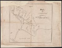
"League and boundary line established by Wm. G. Banks, County Surveyor.", From the Streeter collection., Includes index and inset of "Chart of Galveston Bar and Harbor." Scale [ca. 1:76,000]., and Shows city lots, prominent structures, ships, and steamboats.
Publisher:
s.n.],
Subject (Geographic):
Galveston (Tex.)--Maps
Subject (Name):
Banks, Wm. G, Streeter, Thomas W.--(Thomas Winthrop),--1883-1965--Ownership, and Wagner & M'Guigan
Eastern part, post route map of the state of Texas. and Western part, post route map of the state of Texas.
Description:
"The first edition was issued in 1878.", "The service on this diagram brought up to date of February 1, 1879.", At head of title on cover of sheet 1: Eastern part., At head of title on cover of sheet 2: Western part., From the Stre, and Prime meridian: Washington.
Publisher:
Post Office Dept.,
Subject (Geographic):
Texas--Maps
Subject (Name):
Key, David McKendree, 1824-1900, Streeter, Thomas W.--(Thomas Winthrop),--1883-1965--Ownership, and United States. Post Office Dept
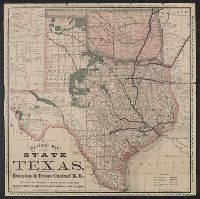
Houston and Texas Central Railway and State of Texas
Description:
"A--12-17-77--5 M.", "Compiled from the official county maps of the general land office, and actual survey, From the Streeter collection., and Text, distance list, and ill. of "Side view, capitol at Austin, Texas" and "Tide water connection at Houston" on verso.
Publisher:
Houston & Texas Central R.R.,
Subject (Geographic):
Texas--Maps
Subject (Name):
Houston & Texas Central Railway Company and Streeter, Thomas W.--(Thomas Winthrop),--1883-1965--Ownership
Subject (Topic):
Railroad land grants--Texas--Maps and Railroads--Texas--Maps
"Though the map ... has an 1840 date, it appears from a letter of J.H. Overton, United States Commissioner, dated Opelousas, Louisiana, August 10 1841 ... and the reply of October 1, 1841 ... that the maps ... had not been forwarded at that time. However, they had been received by January 15, 1842 ... and that they were issued by March 17, 1842, is shown by the reprintings of them accompanying the President's Message of that date"--Streeter, Bibliography of Texas, 1438.
Publisher:
s.n.,
Subject (Geographic):
Sabine River (Tex. and La.)--Maps, Texas--Boundaries--United States--Maps, and United States--Boundaries--Texas--Maps
Subject (Name):
Graham, J. D. (James Duncan), 1799-1865, Pillans, P.J. (Palmer Job), 1816-1898, and Streeter, Thomas W.--(Thomas Winthrop),--1883-1965--Ownership
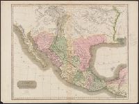
"Drawn & engraved for Thomson's New general atlas.", Appears in A new general atlas ... Edinburgh : John Thomson and Co., From the Streeter collection., In upper right margin: No. 58., and Relief shown by hachures.
Publisher:
John Thomson and Co.,
Subject (Geographic):
Central America--Maps and Mexico--Maps
Subject (Name):
Streeter, Thomas W.--(Thomas Winthrop),--1883-1965--Ownership and Thomson, John, geographer. New general atlas
"Drawn and engraved for Thomsons New general atlas, 1814.", From the Streeter collection., In upper right margin: No. 58., Library's copy annotated in pencil; one note questions whether this map is from the 1817 edition of Thomson's, and Relief shown by hachures.
Publisher:
John Thomson and Co.,
Subject (Geographic):
Central America--Maps and Mexico--Maps
Subject (Name):
Streeter, Thomas W.--(Thomas Winthrop),--1883-1965--Ownership and Thomson, John, geographer. New general atlas
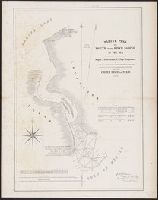
Survey of five leagues of land belonging to Wm P. Harris & others
Description:
"...in the 1837 [New Orleans] directory...P. Snell was listed, 'Canal near Bourbo, Library's copy imperfect: upper left corner missing., Oriented with north toward lower right., and Shows land tracts west of Galveston Bay and north of Clear Lake and Clear Creek.
Publisher:
s.n.,
Subject (Geographic):
Harris County (Tex.)--Maps
Subject (Name):
Harris, William P, Snell, P, and Streeter, Thomas W.--(Thomas Winthrop),--1883-1965--Ownership