Skip to search
Skip to main content
Skip to first result
Search
You Searched For
Format
cartographic
Genre
Engravings
Genre
Illustrations
New Search
Search Results
Published / Created:
1833
Call Number:
2002 Folio 97
Collection Title:
Tanner’s universal atlas : subscription price $1.00 a number, seperate [sic] numbers $1.50 each
Image Count:
1
Resource Type:
Maps, Atlases & Globes
Alternative Title:
II.-Map of the state of Maine
Description:
Plate identified as "II" on atlas cover and "5" on map. and Verso blank.
Subject (Geographic):
Maine
Collection Created:
Philadelphia : Published by the author, 1833-1836
Found in:
Beinecke Rare Book and Manuscript Library > A new map of Maine
Published / Created:
1833
Call Number:
1976 Folio 98
Collection Title:
A new universal atlas, containing maps of the various empires, kingdoms, states and republics of
Image Count:
1
Resource Type:
Maps, Atlases & Globes
Subject (Geographic):
Maine
Collection Created:
Philadelphia, Published by the author, 1836
Found in:
Beinecke Rare Book and Manuscript Library > A new map of Maine
Published / Created:
1850
Call Number:
1976 Folio 96
Collection Title:
A new universal atlas containing maps of the various empires, kingdoms, states and republics of the
Image Count:
1
Resource Type:
Maps, Atlases & Globes
Publisher:
Thomas, Cowperthwait & Co
Subject (Geographic):
Maine
Collection Created:
Philadelphia, Cowperthwait, DeSilver & Butler, 1854, c1850
Found in:
Beinecke Rare Book and Manuscript Library > A new map of Maine
Call Number:
1976 Folio 94
Collection Title:
A new universal atlas containing maps of the various empires, kingdoms, states and republics of the
Image Count:
1
Resource Type:
Maps, Atlases & Globes
Subject (Geographic):
Maine
Collection Created:
Philadelphia, S.A. Mitchell, 1849
Found in:
Beinecke Rare Book and Manuscript Library > A new map of Maine
Creator:
Published / Created:
[1732]
Call Number:
E1015 M66 1732
Collection Title:
Atlas minor: or a set of sixty-two new and correct maps, of all parts of the world. All composed
Image Count:
1
Description:
Autograph of Gravely. Autograph of Baldock. Autograph of Aston. Autograph of W. Alington.
Subject (Geographic):
America--Maps--Early works to 1800
Subject (Topic):
Atlases--Early works to 1800
Collection Created:
London :
Found in:
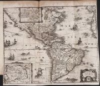
Beinecke Rare Book and Manuscript Library > A new map of the whole world with the trade winds according to ye latest and most exact observations by H. Moll geographer.
Creator:
Published / Created:
[1732]
Call Number:
E1015 M66 1732
Collection Title:
Atlas minor: or a set of sixty-two new and correct maps, of all parts of the world. All composed
Image Count:
1
Description:
Autograph of Gravely. Autograph of Baldock. Autograph of Aston. Autograph of W. Alington.
Subject (Geographic):
America--Maps--Early works to 1800
Subject (Topic):
Atlases--Early works to 1800
Collection Created:
London :
Found in:
Beinecke Rare Book and Manuscript Library > A new map of ye north parts of America claimed by France under ye names of Louisiana. Mississipi, Canada & New France, with the adjoyning territories of England & Spain. By H. Moll geographer.
Call Number:
CF352 I54 1793
Collection Title:
A topographical description of the Western territory of North America; containing a succinct
Image Count:
1
Description:
Engrav'd for S. Campbell's Edition of Imlay's Description of Kentucky., Facing p. 111., and Teaching resource: Professor John Mack Faragher, History 141: The American West.
Subject (Geographic):
Genesee River Valley (Pa. and N.Y.) --Early works to 1800, Mississippi River Valley --Description and travel --Early works to 1800, Mississippi River Valley --History --To 1803, and Ohio River Valley --Description and travel -
Subject (Name):
Filson, John, ca. 1747-1788 Discovery, settlement, and present state of Kentucky, Toulmin, Harry, 1766-1823 Thoughts on emigration, and United States. Dept. of State
Subject (Topic):
Public lands --United States --Early works to 1800
Collection Created:
New-York, Printed by Samuel Campbell, No. 37, Hanover Square, M,DCC,XCIII
Found in:
Beinecke Rare Book and Manuscript Library > A plan of the rapids of the Ohio
Call Number:
1977 +392
Collection Title:
A survey of the cities of London and Westminster : containing the original, antiquity, increase
Image Count:
1
Resource Type:
Maps, Atlases & Globes
Description:
Plate between p. 54-55.
Subject (Geographic):
London (England)--History
Collection Created:
London : Printed for A. Churchill, J. Knapton, R. Knaplock, J. Walthoe [and 6 others], 1720
Found in:
Beinecke Rare Book and Manuscript Library > Aldgate Ward with its division into parishes. Taken from the last survey, with corrections & additions
Call Number:
Taylor 192 4-6
Collection Title:
Americae pars sexta, sive, Historiae ab Hieronymo Be[n]zono Mediolane[n]se scriptae, sectio tertia
Image Count:
1
Subject (Geographic):
America --Early accounts to 1600, Canary Islands --Description and travel --Early works to 1800, Florida --History --Huguenot colony, 1562-1565, Peru --History --Conquest, 1522-1548, and Western Hemisphere --Maps --
Subject (Name):
Benzoni, Girolamo, b. 1519. Historia del Mondo Nuovo. Book 3. Latin and Bry, Theodor de, 1528-1598
Collection Created:
[Frankfurt am Main : Theodore de Bry, 1596]
Found in:
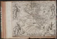
Beinecke Rare Book and Manuscript Library > America Sive Novus Orbis Respectu Europaeorum Inferior Globe Terrestris Pars 1596
Call Number:
Taylor 192 13
Collection Title:
Decima tertia pars historiae Americanae, qvae continet exactam et accvratam descriptionem I. Novae
Image Count:
1
Subject (Geographic):
America --Description and travel and America --History --To 1810
Subject (Name):
Merian, Matthaeus, 1593-1650
Collection Created:
Francofvrti ad Moenum, Sumptibus M. Meriani,
Found in:
Beinecke Rare Book and Manuscript Library > American nouiter delineata
Branch:v1.61.8 ,Deployed:2024-06-20T11:14:46-04:00