"9"--Manuscript note in upper right corner of sheet. Accompanied by: Title page: A complete body of ancient geography by Mons. D'Anville ... London : James Whittle and Richard Holmes Laurie, 1818 (1 sheet)., Includes index., Includes six bar scales., Prime meridian: Ferro., Relief shown by hachures., and Watermark.
Publisher:
Laurie & Whittle,
Subject (Geographic):
Egypt--Administrative and political divisions--Maps. and Egypt--Maps.
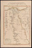
"Octavo, Vol. 2, p. 371" in lower left corner., Imperfect: upper right corner mutilated, with some loss of text. Reinforced on verso with strips of manuscript waste., Relief shown pictorially., and Shows boundaries, rivers and principal settlements.
Publisher:
[publisher not identified],
Subject (Geographic):
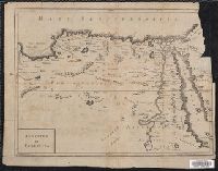
Egypt--Historical geography--Early works to 1800--Maps., Egypt--Maps--Early works to 1800., Libya--Historical geography--Early works to 1800--Maps., and Libya--Maps--Early works to 1800.
"Cum gratia et privil. S.R.I. Vicari atg., in partibg. Rheni, Suevice, et juris Franconici.", Has watermark., Includes ornamental cartouche and text., and Relief shown pictorially.
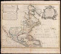
Appears in various eds. of Atlas geographicus maior., Includes German text relating to English and French territorial claims., Place names and descriptive notes in English., Prime meridian: Ferro and London., Relief shown pictorially., and Sheet measures 47.5 x 51 cm.
Publisher:
[Homann Erben],
Subject (Geographic):
North America--Maps--Early works to 1800. and United States--History--French and Indian War, 1755-1763--Maps--Early works to 1800.
Subject (Name):
Anville, Jean Baptiste Bourguignon d', 1697-1782. and Homann Erben (Firm). Atlas geographicus maior.
Appears in various eds. of Atlas geographicus maior., Includes German text relating to English and French territorial claims., Place names and descriptive notes in English., Prime meridian: Ferro and London., and Relief shown pictorially.
Publisher:
[s.n.],
Subject (Geographic):
North America--Maps--Early works to 1800. and United States--History--French and Indian War, 1755-1763--Maps--Early works to 1800.
Subject (Name):
Anville, Jean Baptiste Bourguignon d', 1697-1782. and Homann Erben (Firm). Atlas geographicus maior.
Includes five bar scales., Relief shown pictorially., and Watermark. Manuscript number in upper right corner: jj5. Reinforced at bottom with paper. From the Karpinski Collection.
Publisher:
Venalis prostat Augustae Vindelic apud Jeremiam Wolff,
Subject (Geographic):
North America--Maps.
Subject (Name):
Karpinski, Louis Charles,--1878-1956--Ownership. and Wolf, Jeremias, 1663?-1724, pulbisher.
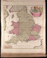
"Cum privilegio.", Appeared in Peter Schenk's Atlas contractus, ca. 1700., Backed with paper. Ms. no. "48" in lower-right corner. Sheet measures 62.8 x 53.7 cm. No. 45 of 87 maps bound together., Bar scales given in "milliaria Anglica," "milliaria Germanica," and "milliaria Gallica"., Prime meridian: Ferro., Relief shown pictorially., and Watermark.
Publisher:
Peter Schenk,
Subject (Geographic):
England--Maps--Early works to 1800.
Subject (Name):
Schenk, Peter, 1660-1718 or 1719. Atlas contractus.
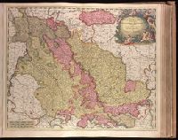
"Cum privil. H. et W-frisiae"., Appeared in Valk and Schenk's Atlantis sylloge compendiosa, ca. 1702., Backed with paper. Ms. no. "36" in upper left-hand corner. Sheet measures 53.6 x 62.8 cm. No. 35 of 87 maps bound together., Bar scales given in "milliaria Germanica," "milliaria Gallica," and "milliaria Italica"., Prime meridian: Ferro., Relief shown pictorially., and Watermark.
Publisher:
Gerard Valk,
Subject (Geographic):
Limburg (Belgium : Province)--Maps--Early works to 1800. and North Rhine-Westphalia (Germany)--Maps--Early works to 1800.
Subject (Name):
Schenk, Peter, 1660-1718 or 1719. Atlantis sylloge compendiosa. and Valck, G. (Gerard), 1651 or 1652-1726. Atlantis sylloge compendiosa.