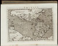
"With charts of the southern part of South America, of part of the Pacific Ocean, and of the track of the Centurion round the world"--T.p., Apparently compiled by Richard Walter and revised by Benjamin Robins (cf. Dictionary of National Biography, v. 48, p. 435)., BEIN 2000 876: Autograph: W. Smith., and Page 541 numbered 441.
Publisher:
Printed for John and Paul Knapton ...,
Subject (Name):
Anson, George Anson,--Baron,--1697-1762, Centurion (Ship), Robins, Benjamin, 1707-1751, Smith, W.--Autograph, and Walter, Richard, 1716?-1785
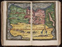
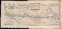
New England: the most remarqueable parts thus named by the high and mighty Prince Charles, nowe King of great Britaine [map] and Path-way to experience to erect a plantation.
Description:
Imperfect: damp-stained; added port. of Charles I., Map with portrait of Capt. Smith in corner: New England ... / observed and described by Captayn John Smith. 1614. Pendleton's Lithography, Boston. Drawn by J. Eddy. London, printed by Geor: Low., Signatures: A-F⁴., and Teaching resource: Professor John Mack Faragher, History 141: The American West.
Publisher:
Printed by I. Haviland, and are to be sold by R. Milbovrne,
Subject (Geographic):
Massachusetts--History--Colonial period, ca. 1600-1775, Massachusetts--Maps--Early works to 1800, New England--Description and travel, New England--History--Colonial period, ca. 1600-1775, and New England--Maps--Early works to 1800
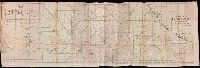
At head of title: December, 1720., Author named in the work as William Stukeley., Beinecke copy was given to Maurice Johnson by the author and contains Johnson's ms. notes., Bound with: of the Roman amphitheater at Dorchester. [London : :s.n, 1723], Caption title., Map and engraving of inscriptions bound in before title page., and Page [1] at end blank.