Hamilton and Balfour (Edinburgh, Scotland) Ruddiman, Thomas, 1674-1757
Published / Created:
Printed in the year [1758]
Call Number:
2000 629
Image Count:
53
Description:
Blanks not digitized. and Imperfect: t.p. bled at bottom, obscuring date of publication; autograph: Thomas Ruddiman; ms. notes; some other pages bled at bottom; armorial bookplate of G. Harvey Johnston.
Publisher:
Catalogues to be had at the shops of Messrs. Kincaid and Donaldson, and Hamilton and Balfour ...,
Subject (Name):
Ruddiman, Thomas,--1674-1757--Autograph and Ruddiman, Thomas,--1674-1757--Library--Catalogs
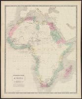
Bartholomew, J. G. (John George), 1860-1920 Edinburgh Geographical Institute
Published / Created:
[1900?]
Call Number:
3229 1900
Container / Volume:
BRBL_00063
Image Count:
1
Resource Type:
Maps, Atlases & Globes
Description:
"Roads revised by the Cyclists' Touring Club"--Bottom margin., "Sheet 12"--Top margin., Indicates first class, secondary and passable roads, footpaths & bridlepaths, hights in feet above sea level, railways and stations, canals, and county boundaries., and Relie
Publisher:
Edinburgh Geographical Institute,
Subject (Geographic):
Cheshire (England)--Maps
Subject (Topic):
Bicycle trails--England--Cheshire--Maps, Cycling--England--Cheshire--Maps, and Roads--England--Cheshire--Maps
Bartholomew, J. G. (John George), 1860-1920 Edinburgh Geographical Institute
Published / Created:
[1890?]
Call Number:
3258 1890
Container / Volume:
BRBL_00069
Image Count:
2
Resource Type:
Maps, Atlases & Globes
Alternative Title:
Hertforshire.
Description:
"Reduced by permission from the, Indicates first class, secondary and passable roads, footpaths & bridlepaths, hights in feet above sea level, railways and stations, canals, and county boundaries., and Relief shown by contours, gradient tints, and spot heights.
Publisher:
Edinburgh Geographical Institute,
Subject (Geographic):
Hertfordshire (England)--Maps
Subject (Topic):
Bicycle trails--England--Hertfordshire--Maps, Cycling--England--Hertfordshire--Maps, and Roads--England--Hertfordshire--Maps
Bartholomew, J. G. (John George), 1860-1920 Edinburgh Geographical Institute
Published / Created:
[19--?]
Call Number:
3225 1900
Container / Volume:
BRBL_00060
Image Count:
1
Resource Type:
Maps, Atlases & Globes
Description:
"Copyright, John Bartholomew., "Roads revised by the Cyclists' Touring Club"--Bottom margin., and Indicates first class, secondary and passable roads, footpaths & bridlepaths, hights in feet above sea level, railways and stations, canals, and county boundaries.
Publisher:
Edinburgh Geographical Institute,
Subject (Geographic):
Essex (England)--Maps and Essex (England)--Maps, Tourist
Subject (Topic):
Bicycle trails--England--Essex--Maps, Cycling--England--Essex--Maps, and Roads--England--Essex--Maps
Bartholomew's half-inch to mile map of England & Wales
Description:
"Reduced ... from the new revised Ordnance Survey, with special local revision and correction to date of publication.", In upper left margin: Sheet 31., and Scale 1 : 126 720 2 miles to an inch.
Bartholomew's half-inch to mile map of England & Wales
Description:
"Reduced ... from the new revised Ordnance Survey, with special local revision and correction to date of publication.", In upper left margin: Sheet 32., and Scale 1 : 126 720 2 miles to an inch.