Search
You Searched For
Search Results
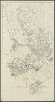
- Creator:
- Germany. Heer. Abteilung für Kriegskarten- und Vermessungswesen
- Published / Created:
- 1942]
- Call Number:
- 344 AK35 1942
- Container / Volume:
- BRBL_00093
- Image Count:
- 1
- Resource Type:
- Maps, Atlases & Globes
- Description:
- "1938.", "IV. 45. KrK uVermA 5.", and Cadastral maps.
- Publisher:
- Die Abteilung,
- Subject (Geographic):
- Akershus fylke (Norway)--Maps and Oslo (Norway)--Maps
- Found in:
- Beinecke Rare Book and Manuscript Library > Aker m = 1:10 000.
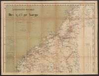
- Published / Created:
- 1884
- Call Number:
- 344 1884
- Container / Volume:
- BRBL_00093
- Image Count:
- 2
- Resource Type:
- Maps, Atlases & Globes
- Description:
- List on margin of "Afstandstabeller for Jerbanerne". and Shows roads, railroads, etc.
- Publisher:
- Carnmermeyer,
- Subject (Geographic):
- Norway--Maps
- Found in:
- Beinecke Rare Book and Manuscript Library > Carnmermeyers Reisekart over det sydlige Norge Udarbeidet efter officielle Karter og Opgaren ved Per Nissen.
- Creator:
- Holtedahl, Olaf, 1885-1975
- Published / Created:
- 1940
- Call Number:
- 344cea 1940
- Container / Volume:
- BRBL_00095
- Image Count:
- 8
- Resource Type:
- Maps, Atlases & Globes
- Description:
- Blad I -- Blad II -- Blad III -- Blad IV -- Blad V -- Blad VI -- Blad VII. and Charts cover entire coast.
- Publisher:
- Utgitt av det Norske Videnskaps-Akademi,
- Subject (Geographic):
- Norway--Maps
- Found in:
- Beinecke Rare Book and Manuscript Library > Dybdekart over de norske kystfarvann med tilgrensende havstrok.
- Creator:
- Norges geografiske oppmåling
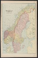
- Published / Created:
- 1922
- Call Number:
- 344eb 1922
- Container / Volume:
- BRBL_00095
- Image Count:
- 1
- Resource Type:
- Maps, Atlases & Globes
- Publisher:
- Norges geogr. Opmaling,
- Subject (Geographic):
- Norway--Population--Maps
- Found in:
- Beinecke Rare Book and Manuscript Library > Folketetthetskart över Nord-Norge.
- Published / Created:
- 1864
- Call Number:
- 344ca 1864
- Container / Volume:
- BRBL_00095
- Image Count:
- 1
- Resource Type:
- Maps, Atlases & Globes
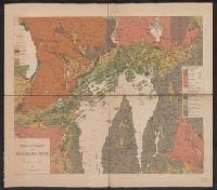
- Description:
- One sheet in four pieces.
- Subject (Geographic):
- Norway--Maps
- Found in:
- Beinecke Rare Book and Manuscript Library > Geologisk Kart over Christiania Omegn af Theodor Kjerulf 1864.
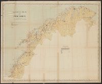
- Creator:
- Landslaget for reiselivet i Norge
- Published / Created:
- [1900?]
- Call Number:
- 344ag 1900
- Container / Volume:
- BRBL_00095
- Image Count:
- 1
- Resource Type:
- Maps, Atlases & Globes
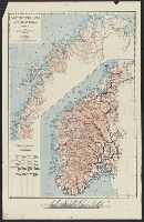
- Description:
- Insets: Profile of mountains, "Havets Overflade.", Relief shown by spot heights., and Shows roads, railways.
- Publisher:
- National Travel Association of Norway,
- Subject (Geographic):
- Norway--Maps
- Found in:
- Beinecke Rare Book and Manuscript Library > Turistkart over Norge = Tourist map of Norway = Carte de Norvège pour les tourists = Touristenkarte über Norwegen.
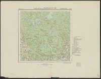
- Creator:
- Germany. Heer. Abteilung für Kriegskarten- und Vermessungswesen
- Published / Created:
- 1944
- Call Number:
- 344 T781 1944
- Container / Volume:
- BRBL_00094
- Image Count:
- 1
- Resource Type:
- Maps, Atlases & Globes
- Alternative Title:
- Norwegen 1:25000 ; Um 25
- Description:
- "IV. 1944 (D6).", In German and Norwegian., Oslo meridian., and Relief indicated by contours and spot heights.
- Publisher:
- Die Abteilung,
- Subject (Geographic):
- Sörkedal Region (Norway)--Maps
- Found in:
- Beinecke Rare Book and Manuscript Library > Umgebungskarte von Tryvasshögda-Kikut.
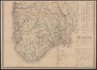
- Creator:
- Waligorski, J
Wergeland, N
- Published / Created:
- [1885?]
- Call Number:
- 344 1885
- Container / Volume:
- BRBL_00093
- Image Count:
- 2
- Resource Type:
- Maps, Atlases & Globes
- Description:
- Districts & counties shown and listed. and Insets: Kart de furnemste Router i Europe--Kart over det nordlige Norge eller Tromsö Stift.
- Publisher:
- Dybwad,
- Subject (Geographic):
- Norway--Maps
- Found in:
- Beinecke Rare Book and Manuscript Library > Veikart over Norge / udarb. af J. Waligorski, N. Wergeland.