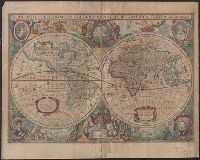
Nova totivs terrarvm orbis geographica ac hydrographica tabvla
Description:
Appears in Jan Jansson's Appendix novi Atlantis (1637) and Jan Jansson and Hendrik Hondius's Atlas novus (1638)., Double hemisphere on sheet, with portraits of Ptolemy, J. Hondius, Caesar and Mercator., Relief shown pictorially., and With dedication to David Sanclarus, Antonius de Willon and Martinius by Hendrik Hondius, dated 1630.
Peutinger table. and Tabula itineraria ex illustri Peutingerorum
Description:
Tabvlae Pevtingerianae segmentvm primvm, ab ostiis Rheni bonnam vsque -- Segmentvm secvndvm à bonna vsque ad Marcomannos -- Tabvlae Pevtingerianae segmentvm III a Marcomannis ad Sarmatas vsque -- Segmentvm IV a Sarmatis vsque ad Hamaxobios -- Tabvlae Pevtingerianae segmentvm V a Sarmatis Hamaxobis vsque ad Roxulanas -- Segmentvm VI a Sarmatis Roxulanis vsque ad Parnacos -- Tabvlae Pevtingerianae segmentvm VII a Parnacis vsque ad Paralocas Schythas -- Segmentvm VIII a Paralocis Schythis vsque ad finem Asiae.
Publisher:
prostant apud Joannem Janssonium,
Subject (Name):
Horn, Georg, 1620-1670, Jansson, Jan, 1588-1664. Accuratissima Orbis antiqui delineatio... [1652?], Jansson, Jan, 1588-1664. Novus atlas, Peutinger, Konrad, 1465-1546 or 7, and Welser, Marcus, 1558-1614
Subject (Topic):
Roads, Roman--Maps--Early works to 1800 and World maps--Early works to 1800