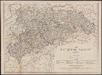
Germany. Heer. Abteilung für Kriegskarten- und Vermessungswesen Germany. Heer. Generalstab. Militärgeographische Angaben über England
Published / Created:
[1940]
Call Number:
3191gfb 1940
Container / Volume:
BRBL_00041
Image Count:
2
Resource Type:
Maps, Atlases & Globes
Alternative Title:
Elektrizitätsversorgung von England und Schottland and Kraftnetz des CEB (Central Electricity Board=Elektrizitätsamt)
Description:
"Anlage zu [i.e. appendix to] Mil. geo. Angaben England"--Upper left margin., "Nicht für den Dienstgebrauch!"--Upper right margin., Includes one table, index to electrical districts and inset map "Das Kabelnetz von London.", and Table "Elektrizitätsversorgung
Publisher:
Gen. St. d.H., Abt. für Kriegskarten u. Vermessungswesen,
Subject (Geographic):
Great Britain--Maps
Subject (Name):
Great Britain.--Central Electricity Board--Maps
Subject (Topic):
Electric lines--Great Britain--Maps, Electric power distribution--Great Britain--Maps, Electric power production--Great Britain--Maps, and Electric utilities--Great Britain--Maps
Bar scale in Deütsche Meylen., From Bry's Decima tertia pars Historiae Americanae [part 13] ... Francofurti ad Moenum : Sumptibus Matthaei Meriani civis ..., 1634., Include scene of naval warfare, town burning, battalions marching, dwellings, churches, topographical details, sea banks or shoals, fortifications, and ships., and With bird's eye-view of Olinda and Recife in Pernambuco, Brazil.
Publisher:
Matthaeus Merian,
Subject (Geographic):
Brazil--Maps--Early works to 1800, Olinda (Brazil)--Views--Early works to 1800, and Recife (Brazil)--Views--Early works to 1800
Subject (Name):
Bry, Theodor de, 1528-1598. America. pars 13 and Merian, Matthaeus, 1593-1650