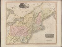
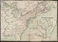
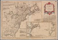
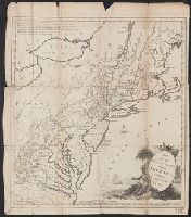
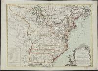
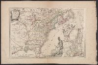
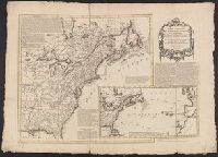
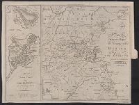
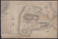
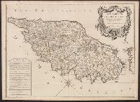
"Avec privilege du Roi". and Insets: [1.] Sault du Niagara, de 135 pieds de haut -- [2. Map of Louisiana territory] -- [3. Map of Mississippi River region].
Publisher:
[Georges-Louis le Rouge], rue des Augustins,
Subject (Geographic):
North America--Maps--Early works to 1800 and United States--History--Revolution, 1775-1783--Maps--Early works to 1800
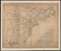
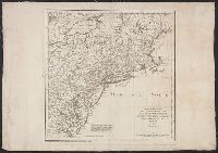
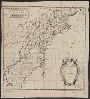
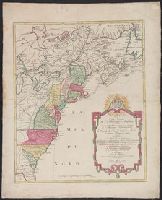
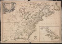
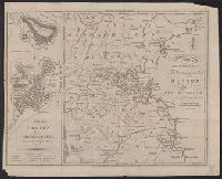
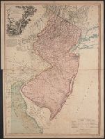
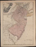
Accompanied by the author's: A topographical description of such parts of North America as are contained in the (annexed) map of the middle British colonies, &c. in North America. vi, 46, 16 p. and Includes text, list of townships, distance charts, and inset
Publisher:
Printed & published ... for J. Almon,
Subject (Geographic):
America, Canada--Maps--Early works to 1800, East (U.S.)--Maps--Early works to 1800, and Northeastern States--Maps--Early works to 1800.
Subject (Name):
Almon, John, 1737-1805, Evans, Lewis, 1700?-1756, and Turner, James, -1759
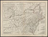
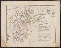
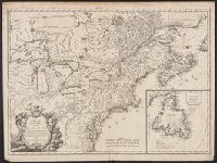
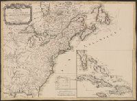
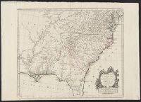
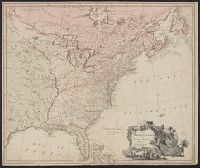
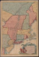
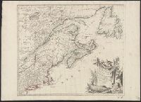
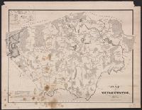
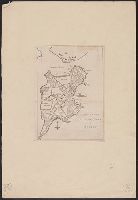
Northern British Colonies and Seat of war, in the northern colonies, containing the province of Quebec, Newfoundland, Nova-Scotia, New-England, New-York, New-Jersey, Pennsylvania, &ca.
Description:
From Robert Sayer and John Bennett's American military pocket atlas (1776)., Imperfect: torn at bottom middle along fold, with some loss of text. Manuscript number of vero: 3., Relief shown pictorially., and Watermark.
Subject (Geographic):
Canada--Maps--Early works to 1800 and New England--Maps--Early works to 1800
Subject (Name):
Holland, Samuel, 1728-1801, Pownall, Thomas, 1722-1805, and Robert Sayer and John Bennett (Firm). American military pocket atlas
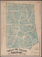
"The plan is to have a rail road track reach every door, in every street of this territory, to the edge of the ocean on one side, and to the heart of the country on the other." and Includes text.
Relief shown by contours. and Shows roads, streets and railroads.
Publisher:
Published by the Appalachian Mountain Club from the proofs of the State map with the permission of the director of the United States Geological Survey and the commissioners of the Topographic Survey of Massachusetts,
Subject (Geographic):
Boston Region (Mass.)--Maps
Subject (Name):
Geological Survey (U.S.) and Massachusetts. Topographical Survey Commission
In center lower margin: Entered according to Act of Congress in the year 1861 by E.P. Dutton & Co. in the Clerks Office of the District Court in the District of Massachusetts., Relief shown by hachures., Sho, and Shows location of buoys, lighthouses, rocks, etc.
Publisher:
E.P. Dutton & Co.,
Subject (Geographic):
Boston Harbor (Mass.)--Maps and Massachusetts--Maps
"Forbes Co.", "Published expressly for the Boston directory.", Covers also parts of adjacent towns and cities, including all of Cambridge, Somerville, and Brookline., Imperfect. Mutilated with loss of text., and Shows radial distances from City Hall.
Publisher:
Sampson, Murdock & Co.,
Subject (Geographic):
Boston (Mass.)--Maps and Boston Metropolitan Area (Mass.)--Maps
American Association for the Advancement of Science
Published / Created:
1880
Call Number:
764 B65 1880A
Container / Volume:
BRBL_00456
Image Count:
1
Resource Type:
Maps, Atlases & Globes
Description:
"The district burnt in the great fire of November 1872 is shown by a series of parallel red lines." and "The original shore-line of the Boston Peninsula is shown by a red line."
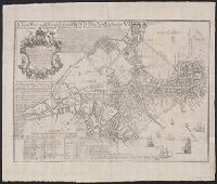
Gentleman's magazine (London, England) and Plan of the town of Boston
Description:
"Charles Town in ruins" is indicated in the northern part of the map., By Robert Aitken; no engraver's signature., From: The gentleman's magazine, v. 45, Oct. 1775., Relief shown pictorially., and Shows streets, wharves, fortifications, and The Common.
Publisher:
Gentleman's magazine,
Subject (Geographic):
Boston (Mass.)--Buildings, structures, etc.--Maps--Early works to 1800 and Boston (Mass.)--Maps--Early works to 1800
Subject (Topic):
Fortification--Massachusetts--Boston--Maps--Early works to 1800
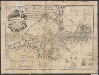
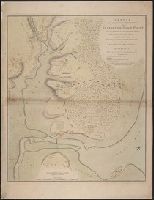
Depths shown by soundings., From Gentleman's magazine, vol. 45, Jan. 1775., and In center of lower margin: Feby. 1st 1775.
Publisher:
s.n.,
Subject (Geographic):
Boston Harbor Islands Region (Mass.)--Maps--Early works to 1800, Boston Harbor Region (Mass.)--Maps--Early works to 1800, and Boston Metropolitan Area (Mass.)--Maps--Early works to 1800
Based on John Bonner's map, "The town of Boston in New England" (1722)., In cartouche below title: "To His Excellency Jonathan Belcher Esqr"., Includes description of Boston, indexes of wards and buildings, and dates of fires and smallpox epidemics., and Oriente
Publisher:
William Price,
Subject (Geographic):
Boston (Mass.)--Maps--Early works to 1800
Subject (Name):
Belcher, Jonathan, 1682-1757. dedication and Bonner, John, ca. 1643-1726. The town of Boston in New England 1722
Based on John Bonner's map, "The town of Boston in New England" (1722)., Copy 1: Verso: Stamped "Yale Horace Brown 1900S"., In cartouche below title: "To His Excellency Jonathan Belcher Esqr"., and Includes description of Boston, indexes of wards and buildings,
Publisher:
William Price,
Subject (Geographic):
Boston (Mass.)--Maps--Early works to 1800
Subject (Name):
Belcher, Jonathan, 1682-1757. dedication and Bonner, John, ca. 1643-1726. The town of Boston in New England 1722
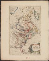
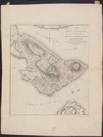
"N.B. The ground plan is from an actual survey of Captn. Montresor.", A copy of this issue is included in William Faden's Atlas of the battles of the American Revolution. [New York, 1845], and An engraved map, with change of title, appears in Stedman's History
Subject (Geographic):
United States--History--Revolution, 1775-1783--Maps--Early works to 1800
Subject (Name):
Montrésor, John, 1736-1799
Subject (Topic):
Bunker Hill, Battle of, 1775--Maps, Manuscript--Early works to 1800
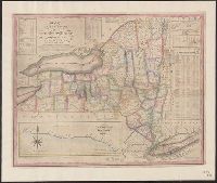
Profile of the northern canal and Profile of the western canal, H. Phelps, New York, 1832
Description:
Below title is lo, Folded into red publisher's boards stamped: New York., Inset tables provide information on distances and routes, colleges in the state, population, and newspapers published in state., and Insets show profiles of Erie Canal and Champlain Canal.
Publisher:
Humphrey Phelps,
Subject (Geographic):
Champlain Canal (N.Y.)--Maps, Erie Canal (N.Y.)--Maps, and New York (State)--Maps
"A. Pl. 17.", From Nicolas-Gabriel Clerc's Histoire physique, morale, civile et politique de la Russie moderne., Relief shown by hachures., Stamp on verso: Douane francaises ... 31 avr 70., and Watermark.
Subject (Geographic):
Caspian Sea--Maps--Early works to 1800
Subject (Name):
Clerc, Nicolas-Gabriel, 1726-1798. Histoire physique, morale, civile et politique de la Russie moderne and Tardieu, P. F. (Pierre François), 1757-1822, engraver
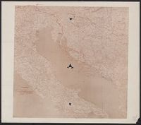
"Leggenda, Rivendicazioni Italiane [shown in solid red line], Confine amministrativo della Dalmazia oltre la zona limitata dal Patto di Londres [shown in dotted blue line].", Coordinates not present on map and are approximated., and Imperfect: torn along fold i
Subject (Geographic):
Adriatic Sea--Maps
Subject (Topic):
Treaty of London--(1915), World War, 1914-1918--Diplomatic history, World War, 1914-1918--Territorial que, World War, 1914-1918--Territorial questions--Croatia, and World War, 1914-1918--Territorial questions--Italy
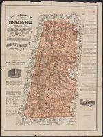
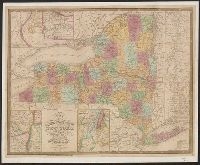
Description derived from published bibliography., Detailed map showing relief by hachures, drainage, township and county boundaries, cities and towns, canals, roads, and railroads., and Inset: City and county of New-York, Brooklyn, Williamsburg & Jersey City. 7
Subject (Geographic):
New York (State)--Maps and United States--New York (State)
Tardieu, P. F. (Pierre François), 1757-1822, author
Call Number:
451 1785
Container / Volume:
BRBL_00258
Image Count:
1
Resource Type:
Maps, Atlases & Globes
Description:
"A. Pl. 36.", Bar scales given in "Echelle Russe" and "Echelle d'une Lieue Franc̦aise.", From Nicolas-Gabriel Clerc's Histoire physique, morale, civile et politique de la Russie moderne., Includes legend to right of map., North oriented towards the left., and Reli
Subject (Geographic):
Cahul (Moldova)--Maps--Early works to 1800
Subject (Name):
Clerc, Nicolas-Gabriel, 1726-1798. Histoire physique, morale, civile et politique de la Russie moderne
Tardieu, P. F. (Pierre François), 1757-1822, author
Call Number:
45 1785
Container / Volume:
BRBL_00258
Image Count:
1
Resource Type:
Maps, Atlases & Globes
Description:
"A. Pl. 37.", Bar scales given in "Verstes" and "Lieue.", Coordinates not present on map and are approximated., From Nicolas-Gabriel Clerc's Histoire physique, morale, civile et politique de la Russie moderne., and Imperfect: torn along fold at center, with no lo
Subject (Geographic):
Tulcea (Romania : Județ)--Maps--Early works to 1800
Subject (Name):
Clerc, Nicolas-Gabriel, 1726-1798. Histoire physique, morale, civile et politique de la Russie moderne
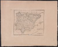
In upper right margin: Taf. VI., Possibly from Ukert's Geographie der Griechen und Römer von den frühesten zeiten bis auf Ptolemäus., and Relief shown by hachures.
Subject (Geographic):
Spain--Maps
Subject (Name):
Ukert, F. A. (Friedrich August), 1780-1851. Geographie der Griechen und Römer von den frühesten zeiten bis auf Ptolemäus
Tardieu, P. F. (Pierre François), 1757-1822, author
Call Number:
451 1770
Container / Volume:
BRBL_00258
Image Count:
1
Resource Type:
Maps, Atlases & Globes
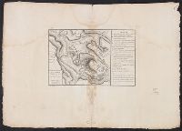
Description:
"A. Pl. 34.", Bar scales given in "Echelle de 600 Sagenes" and "Echelle de 600 Toises.", Coordinates not present on map and are approximated, From Nicolas-Gabriel Clerc's Histoire physique, morale, civile et politique de la Russie moderne., and Includes legend to
Subject (Geographic):
Bender (Moldova)--Maps--Early works to 1800
Subject (Name):
Clerc, Nicolas-Gabriel, 1726-1798. Histoire physique, morale, civile et politique de la Russie moderne
Tardieu, P. F. (Pierre François), 1757-1822, author
Call Number:
45 1771
Container / Volume:
BRBL_00258
Image Count:
1
Resource Type:
Maps, Atlases & Globes
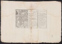
Description:
"A. Pl. 38.", Bar scales given in "Verstes" and "Lieue.", Coordinates not present on map and are approximated., From Nicolas-Gabriel Clerc's Histoire physique, morale, civile et politique de la Russie moderne., Includes index., and North oriented towards the botto
Subject (Geographic):
Tulcea (Romania : Județ)--Maps--Early works to 1800
Subject (Name):
Clerc, Nicolas-Gabriel, 1726-1798. Histoire physique, morale, civile et politique de la Russie moderne
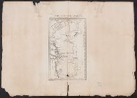
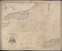
Covers area between New York City and St. Louis, Mo., in northern United States., Includes distance table., and Shows some drainage, state boundaries, and place names along the railroad lines.
Tardieu, P. F. (Pierre François), 1757-1822, author
Call Number:
3543 1785
Container / Volume:
BRBL_00113
Image Count:
1
Resource Type:
Maps, Atlases & Globes
Description:
"A. Pl. 18.", From Nicolas-Gabriel Clerc's Histoire physique, morale, civile et politique de la Russie moderne., Prime meridians: Ferro and Paris., Relief shown by hachures., Stamp on verso: Douane francaises ... 31 avr 70., and Watermark.
Subject (Geographic):
Terek River Valley (Georgia and Russia)--Maps--Early works to 1800
Subject (Name):
Clerc, Nicolas-Gabriel, 1726-1798. Histoire physique, morale, civile et politique de la Russie moderne
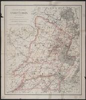
Appeared in Willem and Joan Blaeu's Theatrum orbis terrarum., Backed with linen., Coordinates not present on map and are approximated., Relief shown pictorially., and With north oriented towards the upper right.
Subject (Geographic):
Netherlands--Maps--Early works to 1800
Subject (Name):
Blaeu, Joan, 1596-1673. Theatrum orbis terrarum, Blaeu, Willem Janszoon, 1571-1638. Theatrum orbis terrarum, and Ende, Josua van den, approximately 1584-approximately 1634, engraver