Chernyshov, Ivan Georgievich Dury, Andrew., creator Sayer, Robert, 1725-1794
Published / Created:
1787 October 24
Call Number:
1982 Folio 10
Image Count:
1
Alternative Title:
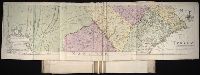
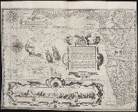
Map of the present seat of war, between the Russians, Poles, and Turk
Description:
Also shows parts of Hungary and Poland., Includes paste-on addition to northwestern sheet depicting Bosnia, Herzegovina, and the Dalmatian Coast., No. 26 of 43 maps bound together in composite atlas., Prime meridian: Ferro., Relief shown pictorially., Scale [ca. 1:2,500,000]., and Sheets mounted together to form 2 sheets.
Publisher:
Wm. Faden
Subject (Geographic):
Black Sea --Maps --Early works to 1800 and Russia --Maps --Early works to 1800
Subject (Topic):
Russo-Turkish War, 1787-1792 --Maps --Early works to 1800
Map of the improved part of the province of Pennsylvania
Description:
BEIN 2003 Folio 85: No. 20 of 45 maps bound together with binder's spine title: Atlas of America; ms. table of contents. Bookplate: Robinson. Bookplate of Paul Mellon., Hand colored., Relief shown pictorially., Scale [ca. 1:250,000]., and Shows county boundaries.
Publisher:
Sold by the author, Nicholas Scull
Subject (Geographic):
Pennsylvania -- Administrative and political divisions -- Maps -- Early works to 1800 and Pennsylvania -- Maps -- Early works to 1800
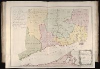
Lansdowne, William Petty, Marquis of, 1737-1805 Park, Moses, 1738-1828, creator
Published / Created:
1766
Call Number:
2003 Folio 85
Image Count:
1
Alternative Title:
Plan of the colony of Connecticut in North-America
Description:
Available also through the Library of Congress Web site as a raster image., BEIN 2003 Folio 85: No. 19 of 45 maps bound together with binder's spine title: Atlas of America; ms. table of contents. Bookplate: Robinson. Bookplate of Paul Mellon., Hand colored., LC Maps of North America, 1750-1789,, Relief shown pictorially., Scale [ca. 1:275,000]., and Shows counties, towns, rivers, and post roads.
Publisher:
s.n
Subject (Geographic):
Connecticut -- Administrative and political divisions -- Maps -- Early works to 1800 and Connecticut -- Maps -- Early works to 1800
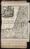
Twenty four new and accurate maps of the several parts of Europe ... : all (except the last) new
Image Count:
1
Alternative Title:
Turkey in Europe
Description:
In pencil on verso: 24. and Table of contents for maps 20-24 misnumbered.
Subject (Geographic):
Turkey --Maps
Subject (Name):
Barker, B. (Benjamin), d. 1764, bookseller, Clements, Henry, d. 1719, bookseller, King, Charles, d. 1735, bookseller, Nicholson, John, d. ca. 1717, bookseller, Parker, Richard, fl. 1692-1725, bookseller, and Tooke, Benjamin, d. 1716, bookseller
Subject (Topic):
Atlases --Early works to 1800
Collection Created:
[London] : Sold by J. Nicholson at the King’s-Arms in Little Britain, Benj. Barker and Charles King ..., Benj. Tooke ..., Hen. Clements ..., R. Parker and Ralph Smith under the Royal-Exchange ..., [1715?]
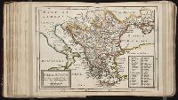
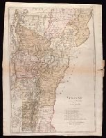
Bohn, Carl Ernst, publisher Ebeling, Christophe Daniel, 1741-1817. Erdbeschreibung und Geschichte von Amerika Schmidt, Paulus, engraver Sotzmann, D. F
Published / Created:
1796
Call Number:
1977 Folio 177
Image Count:
2
Resource Type:
Maps, Atlases & Globes
Description:
"Zu Ebelings Erdbeschreibung von Amerika.", Also shows county boundaries., Bar scales given in "Geographische Meilen 15 auf einen Grad" and "Englische meilen 69 4/25 auf einen Grad.", In upper right margin: No. XVI., Place names in German and English., Prime meridians: Greenwich and Washington., Relief shown by hachures., Sheet measures 72.8 x 54.3 cm. No. 10 of 34 maps bound together., and Watermark.
Publisher:
Bey Carl Ernst Bohn,
Subject (Geographic):
Vermont--Administrative and political divisions--Maps--Early works to 1800 and Vermont--Maps--Early works to 1800
The West-India pilot: containing piloting directions for Port Royal and Kingston harbours in
Image Count:
1
Subject (Geographic):
Atlantic Ocean --Maps --Early works to 1800, Central America --Maps --Early works to 1800, and Honduras --Maps
Subject (Topic):
Harbors --Atlantic Coast (North America) --Maps --Early works to 1800, Nautical charts --Atlantic Coast (North America) --Early works to 1800, Nautical charts --Caribbean Area --Early works to 1800, Nautical charts --West Indies --Early works to 1800, Pilot guides --Atlantic Coast (North America) --Early works to 1800, Pilot guides --Caribbean Area --Early works to 1800, and Pilot guides --West Indies --Early works to 1800
Collection Created:
London : Printed for the author and sold by S. Hooper ..., MDCCLXXI [1771]
The generall historie of Virginia, New-England, and the Summer Iles : with the names of the
Image Count:
1
Abstract:
Inset depicting Powhatan.
Description:
Between p. 40-41. and Teaching resource: Professor John Mack Faragher, History 141: The American West.
Subject (Geographic):
Virginia --Maps --Early works to 1800
Subject (Topic):
Discoveries in geography, First contact of aboriginal peoples with Westerners, Indians of North America --Virginia --Early works to 1800, and Voyages and travels
Collection Created:
London : Printed by I.[ohn] D.[awson] and I.[ohn] H.[aviland] for Michael Sparkes, 1625