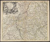
Bar scale given in "echelle de cent lieues Francoises"., Copy 3: Sh, Includes notes., Inset: Carte particuliere des embouchures de la riviere S. Louis et de la Mobile. Scale [ca. 1:2,700,000]., Relief shown pictorially., and Shows some explorers' routes.
Publisher:
Chez Jean Cóvens et Corneille Mortier, geographes,
Subject (Geographic):
Louisiana--Maps--Early works to 1800, Mississippi River Valley--Maps--Early works to 1800, and United States--Maps--Early works to 1800
Subject (Name):
Cóvens et Mortier. Atlas nouveau and Le Maire, François
Appears in the Cóvens et Mortier's Atlas nouveau, 1730 and later eds., Bar scale given in "echelle de cent lieues Francoises"., Copy 2: With watermark. Sheet measures 54.6 x 63.4 cm., and Inset: Carte particuliere des embouchures de la riviere S. Louis et de la
Publisher:
Chez Jean Cóvens et Corneille Mortier, geographes,
Subject (Geographic):
Louisiana--Maps--Early works to 1800, Mississippi River Valley--Maps--Early works to 1800, and United States--Maps--Early works to 1800
Subject (Name):
Cóvens et Mortier. Atlas nouveau and Le Maire, François
Appears in the Cóvens et Mortier's Atlas nouveau, 1730 and later eds., Bar scale given in "echelle de cent lieues Francoises"., Copy 1: Bookseller's label: Libreria Loescher e Co. ... Roma. Mounted on linen. Sheet measures 56.5 x 65.8 cm., and Covers eastern Un
Publisher:
Chez Jean Cóvens et Corneille Mortier, geographes,
Subject (Geographic):
Louisiana--Maps--Early works to 1800, Mississippi River Valley--Maps--Early works to 1800, and United States--Maps--Early works to 1800
Subject (Name):
Cóvens et Mortier. Atlas nouveau and Le Maire, François
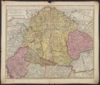
Copy 2 shows new boundary line following the banks of crossing to the east branch of the Cooper River. Several coastal islands and Indian settlements are colore differently from the mainland; these vary in some cases from the jurisdiction as indicated in
Colored map of the coast from just south of the Santee River to just south of the So. Edistow R. Shows many names of early settlers along rivers and near Charleston. Given as No. 105 in Vol.7, Ottens, R., Atlas maior, 1641-1729, by Phillips, Neptune Franc
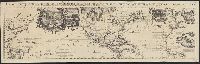
In top margin of sheet 1: Le tout pour l'intelligence des dissertations suivantes., Includes portraits of explorers, illustrations of indigenous peoples, wildlife, flora, historical notes, and ecclesiastical plot ownerships in Havana and Veracruz., and Shows sa
Publisher:
s.n.,
Subject (Geographic):
North America--Maps--Early works to 1800, Pacific Ocean--Maps--Early works to 1800, and South America--Maps--Early works to 1800