Twenty four new and accurate maps of the several parts of Europe ... : all (except the last) new
Image Count:
1
Alternative Title:
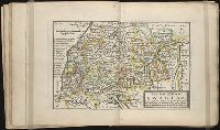
Swabia and Franconia, with the Duke of Marlborough's march to Hochstet, &c
Description:
In pencil on verso: 12.
Subject (Geographic):
Franconia (Germany) --Maps, Germany --Maps --Early works to 1800, and Swabia (Germany) --Maps --Early works to 1800
Subject (Name):
Barker, B. (Benjamin), d. 1764, bookseller, Clements, Henry, d. 1719, bookseller, King, Charles, d. 1735, bookseller, Nicholson, John, d. ca. 1717, bookseller, Parker, Richard, fl. 1692-1725, bookseller, and Tooke, Benjamin, d. 1716, bookseller
Subject (Topic):
Atlases --Early works to 1800
Collection Created:
[London] : Sold by J. Nicholson at the King’s-Arms in Little Britain, Benj. Barker and Charles King ..., Benj. Tooke ..., Hen. Clements ..., R. Parker and Ralph Smith under the Royal-Exchange ..., [1715?]
Twenty four new and accurate maps of the several parts of Europe ... : all (except the last) new
Image Count:
1
Alternative Title:
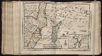
The south-east part of Germany, viz. Bavaria, Newburgh, Saltzburgh, Bohemia, Moravia, Austria, Styria, Carinthia, Carniola, Brixen, Trent, Tirol, &c
Description:
In pencil on verso: 10.
Subject (Geographic):
Austria --Maps --Early works to 1800, Bavaria (Germany) --Maps --Early works to 1800, Bohemia and Moravia (Protectorate, 1939-1945), Germany --Maps --Early works to 1800, and Styria (Austria) --Maps
Subject (Name):
Barker, B. (Benjamin), d. 1764, bookseller, Clements, Henry, d. 1719, bookseller, King, Charles, d. 1735, bookseller, Nicholson, John, d. ca. 1717, bookseller, Parker, Richard, fl. 1692-1725, bookseller, and Tooke, Benjamin, d. 1716, bookseller
Subject (Topic):
Atlases --Early works to 1800
Collection Created:
[London] : Sold by J. Nicholson at the King’s-Arms in Little Britain, Benj. Barker and Charles King ..., Benj. Tooke ..., Hen. Clements ..., R. Parker and Ralph Smith under the Royal-Exchange ..., [1715?]
Twenty four new and accurate maps of the several parts of Europe ... : all (except the last) new
Image Count:
1
Alternative Title:
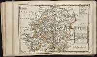
The south part of France, viz. Burgundy, Lyonois, Guienne, Languedoc, Dauphine and Provence
Description:
In pencil on verso: 17.
Subject (Geographic):
Burgundy (France) --Maps --Early works to 1800, Dauphine (France) --Maps, France --Maps --Early works to 1800, Guyenne (France) --Maps, Languedoc (France) --Maps --Early works to 1800, Lyon (France) --Maps, and Provence-Alpes-Cote d'Azur (France) --Maps
Subject (Name):
Barker, B. (Benjamin), d. 1764, bookseller, Clements, Henry, d. 1719, bookseller, King, Charles, d. 1735, bookseller, Nicholson, John, d. ca. 1717, bookseller, Parker, Richard, fl. 1692-1725, bookseller, and Tooke, Benjamin, d. 1716, bookseller
Subject (Topic):
Atlases --Early works to 1800
Collection Created:
[London] : Sold by J. Nicholson at the King’s-Arms in Little Britain, Benj. Barker and Charles King ..., Benj. Tooke ..., Hen. Clements ..., R. Parker and Ralph Smith under the Royal-Exchange ..., [1715?]
Twenty four new and accurate maps of the several parts of Europe ... : all (except the last) new
Image Count:
1
Alternative Title:
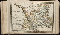
The south-west part of Germany, viz. Mentz and Treeves, Palatine of the Rhine, circles of Franconia, Swabia and Alsace, Lorain the Weteraw, &c
Description:
In pencil on verso: 11.
Subject (Geographic):
Alsace (France) --Maps, Franconia (Germany) --Maps, Germany --Maps --Early works to 1800, Lorraine (France) --Maps, Mainz (Rhineland-Palatinate, Germany) --Maps, Rhineland-Palatinate (Germany) --Maps, Swabia (Germany) --Maps --Early works to 1800, and Trier (Germany) --Maps
Subject (Name):
Barker, B. (Benjamin), d. 1764, bookseller, Clements, Henry, d. 1719, bookseller, King, Charles, d. 1735, bookseller, Nicholson, John, d. ca. 1717, bookseller, Parker, Richard, fl. 1692-1725, bookseller, and Tooke, Benjamin, d. 1716, bookseller
Subject (Topic):
Atlases --Early works to 1800
Collection Created:
[London] : Sold by J. Nicholson at the King’s-Arms in Little Britain, Benj. Barker and Charles King ..., Benj. Tooke ..., Hen. Clements ..., R. Parker and Ralph Smith under the Royal-Exchange ..., [1715?]
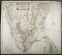
Map with relief shown pictorially, by hachures, and bathymetric soundings., No. 32 of 43 maps bound together in composite atlas., and Scale [ca. 1: 720 000].
Publisher:
Printed for Wm. Faden
Subject (Geographic):
India, South --History, Military --Maps --Early works to 1800
Dominions of Turky in Europe in which are the governments of Romelia of the sea, of Buda, of Teme's war, and of Bosnia ... described by Sanson, corrected and amended by William Berry
Description:
Bar scales in Italian miles, common leagues of France, common leagues of Germany or great leagues of Poland, leagues of Hungary, and leagues that are of one hours travelling., Dedicated To the most serene and most sacred majesty Charles II ... by William Berry., No. 24 of 69 maps bound together in composite atlas., Relief shown pictorially., and Scale [ca. 1:3 500 000].
Publisher:
Sold by William Berry at the signe of the Globe between Charing-Cross and White-Hall
Subject (Geographic):
Balkan Peninsula --Maps --Early works to 1800, Italy --Maps --Early works to 1800, and Turkey --Maps --Early works to 1800
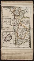
Bar scales given in English miles and Spanish leagues., Includes inset maps The Groyne, A general chart from England to Spain, Vigo and Bayonna, Porto, Lisbon and St. Ubes, and The harbour of Cadiz., No. 9 of 69 maps bound together in composite atlas., Relief shown pictorially., and Scale [ca. 1:1 800 000].
Publisher:
Sold by Christopher Browne at the Globe near the west end of St. Pauls Church