United States. Office of Strategic Services. Research and Analysis Branch
Published / Created:
1943
Call Number:
652gm 1943
Container / Volume:
BRBL_00343
Image Count:
1
Resource Type:
Maps, Atlases & Globes
Description:
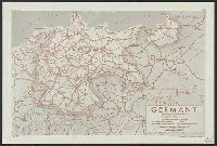
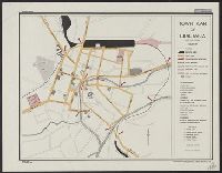
"Map no. 1114 1 M, "This map includes only the main roads compiled from 1940 official road maps (1:1,000,000) and special reports in the Office of Strategic Service s.", and Shows road conditions, railroad gauges, and year-round and seasonally navigable rivers.
Publisher:
OSS,
Subject (Topic):
Railroads--Congo (Democratic Republic)--Maps, Roads--Congo (Democratic Republic)--Maps, and Waterways--Congo (Democratic Republic)--Maps