Anville, Jean Baptiste Bourguignon d', 1697-1782 Chapman, Thomas, fl. 1790-1803 Neele, Samuel John, 1758-1824, engraver Pauw, Cornelius, 1739-1799. Philosophical dissertations on the Egyptians and Chinese
Published / Created:
Jany. 1st, 1795.
Call Number:
1977 Folio 177
Image Count:
2
Resource Type:
Maps, Atlases & Globes
Description:
"Neele, sculpt.", Ms. note at head of title: De Pauw. Sheet measures 50.7 x 63.8 cm. No. 15 of 34 maps bound together., Prime meridians: Ferro., Relief shown pictorially., and Watermark.
Electorate of Brunswick-Luneburg with its dependencies
Description:
Imperfect: torn along fold, with some loss of text. Sheet measures 75.0 x 62.4 cm. No. 30 of 34 maps bound together., Inset map: Plan of the battle of Minden on the 1st of August 1759., Prime meridian: Ferro., and Relief shown pictorially.
Jefferson, Thomas, 1743-1826 Jefferson, Thomas, 1743-1826. Notes on the state of Virginia Neele, Samuel John, 1758-1824, engraver Stockdale, John, 1749?-1814
Published / Created:
1787
Call Number:
1977 Folio 177
Image Count:
2
Resource Type:
Maps, Atlases & Globes
Description:
"The country on the eastern side of the Alleganey Mountains, is taken from Fry and Jefferson's Map of Virginia and Scull's Map of Pennsylvania ... that on the western side of the Alleganey, is taken from Hutchins ... additions have been made, where they could be made on sure ground.", From the author's Notes on the State of Virginia. 1787., Prime meridian: Philadelphia., Relief shown pictorially and by hachures., Sheet measures 66.3 x 60.3 cm. No. 1 of 34 maps bound together., and Shows boundaries.
Bar scales given in "great French leagues," "common French leagues," and "British miles"., Prime meridian: Paris., Relief shown pictorially., Sheet measures 55.6 x 73.6 cm. No. 16 of 34 maps bound together., and Watermark.
Publisher:
Printed for Robert Sayer,
Subject (Geographic):
France--Administrative and political divisions--Maps--Early works to 1800 and France--Maps--Early works to 1800
Bar scale given in Geometrical or Common Miles, British & French Leagues., Imperfect: 7 sheets wanting [upper right and upper middle sheets only]. Sheets measure 70.0 x 50.5 cm or smaller. No. 22 of 34 maps bound together., Includes explanation and scales; insets of "A map of Scotland" and "2d chart of the coast of France from Ostend to Ambleteuse.", and Relief shown pictorially.
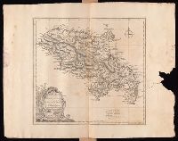
Hoüel, Jean-Pierre-Laurent, 1735-1813 Jefferys, Thomas, d. 1771
Published / Created:
[1768]
Call Number:
1977 Folio 177
Image Count:
2
Resource Type:
Maps, Atlases & Globes
Description:
Bar scales given in "British miles 69 to a degree" and "British and French sea leagues 20 to a degree"., Imperfect: torn and mutilated on the right side, with no loss of text. Sheet measures 44.5 x 56.5 cm. No. 13 of 34 maps bound together., Prime meridian: Ferro., Relief shown by hachures; depths by soundings., Shows habitation or plantations, sugar works, oxen and water mills, observations points, etc., and Watermark.