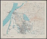
Great Britain. War Office. General Staff. Geographical Section
Published / Created:
1945
Call Number:
56 N15 1945
Container / Volume:
BRBL_00297
Image Count:
1
Resource Type:
Maps, Atlases & Globes
Alternative Title:
[U.S. Army Map Service. A.M.S. ; L901], GSGS (Series) ; 3831., Its [G.S.G.S.] ; 3831, and Series (Standard map series designation system) ; L901.
Description:
"5-45.", "Contour interval 10 metres.", At head of title: China., Four classes of roads and paths are shown; some streets and buildings are named; areas of vegetation and cultivation are shown., and Military grid.
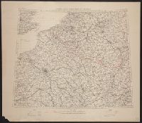
Great Britain. War Office. General Staff. Geographical Section
Published / Created:
[1918?]
Call Number:
38fd 1918
Container / Volume:
BRBL_00170
Image Count:
1
Resource Type:
Maps, Atlases & Globes
Alternative Title:
GSGS (Series) ; 3700.
Description:
"G.S.G.S. 3700.", Ordnance Survey, November 1918., Relief shown by spot heights., and Shows boundaries as in 1792, 1814, and 1815. To illustrate the post-WW1 settlement.
Publisher:
Ordnance Survey,
Subject (Geographic):
Belgium--Boundaries--France--Maps, France--Boundaries--Belgium--Maps, France--Boundaries--Germany--Maps, and Germany--Boundaries--France--Maps
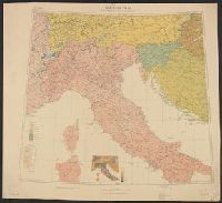
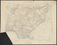
Great Britain. War Office. General Staff. Geographical Section
Published / Created:
1918
Call Number:
11hcf 1919D-6
Image Count:
1
Resource Type:
Maps, Atlases & Globes
Alternative Title:
G.S.G.S. ; 3703a and GSGS (Series) ; 3703a.
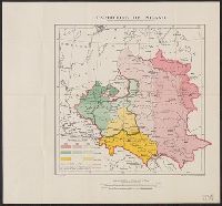
Description:
Includes graph "Population of certain towns." and index to adjoining maps in series. and Inset map: Density of population.
Publisher:
War Office [G.S.G.S.],
Subject (Geographic):
Balkan Peninsula--Maps, Europe, Central--Maps, and Italy--Maps
Subject (Topic):
Ethnology--Balkan Peninsula--Maps, Ethnology--Europe, Central--Maps, Ethnology--Italy--Maps, Population density--, Population density--Balkan Peninsula--Maps, and Population density--Europe, Central--Maps
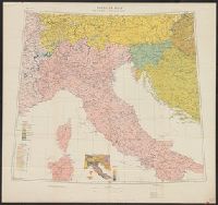
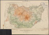
Great Britain. War Office. General Staff. Geographical Section
Published / Created:
1918
Call Number:
40ed 1918
Container / Volume:
BRBL_00229
Image Count:
1
Resource Type:
Maps, Atlases & Globes
Alternative Title:
G.S.G.S. ; 3703a and GSGS (Series) ; 3703a.
Description:
Includes graph "Population of certain towns." and index to adjoining maps in series. and Inset map: Density of population.
Publisher:
War Office [G.S.G.S.],
Subject (Geographic):
Balkan Peninsula--Maps, Europe, Central--Maps, and Italy--Maps
Subject (Topic):
Ethnology--Balkan Peninsula--Maps, Ethnology--Europe, Central--Maps, Ethnology--Italy--Maps, Population density--, Population density--Balkan Peninsula--Maps, and Population density--Europe, Central--Maps
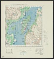
Great Britain. War Office. General Staff. Geographical Section
Published / Created:
1942,
Call Number:
344 T75 1943
Container / Volume:
BRBL_00094
Image Count:
1
Resource Type:
Maps, Atlases & Globes
Alternative Title:
Geographical Section, General Staff ; No. 4246, GSGS (Series) ; 4246., and Tromsö omegn
Description:
"Contour interval 30 metres.", "Reproduced from Norwegian map of 1932 by O.S., 1942.", "War Office, 1942.", Includes notes and diagrams., Military grid., and Relief shown by contours and spot heights.
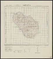
Great Britain. War Office. General Staff. Geographical Section
Published / Created:
1943
Call Number:
40 P19 1942
Container / Volume:
BRBL_00213
Image Count:
1
Resource Type:
Maps, Atlases & Globes
Alternative Title:
Geographical Section, General Staff ; no. 4162 and GSGS (Series) ; 4162.
Description:
"3-43.", "Copied from an Italian map of 1896.", "Grid added November 1942.", Military grid., and Relief shown by contours, rock drawings, and spot heights.