Search
You Searched For
Search Results
- Creator:
- Geological Survey (U.S.)
- Published / Created:
- [1900]
- Call Number:
- 846gc C786 1896
- Container / Volume:
- BRBL_00623
- Image Count:
- 1
- Resource Type:
- Maps, Atlases & Globes
- Found in:
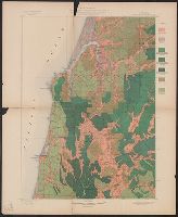
- Beinecke Rare Book and Manuscript Library > Oregon, Coos Bay quadrangle : land classification and density of standing timber / U.S. Geological Survey ; R.U. Goode, geographer in charge ; triangulation by W.T. Griswold ; topography by E.C. Barnard ; Henry Gannett, geographer in charge ; land classif
- Creator:
- Geological Survey (U.S.)
- Published / Created:
- [1900].
- Call Number:
- 846gc R72 1895
- Container / Volume:
- BRBL_00623
- Image Count:
- 1
- Resource Type:
- Maps, Atlases & Globes
- Found in:
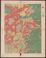
- Beinecke Rare Book and Manuscript Library > Oregon, Roseburg quadrangle : land classification and density of standing timber / U.S. Geological Survey ; Henry Gannett, chief topographer ; R.U. Goode, geographer in charge ; triangulation by W.T. Griswold ; topography by E.C. Barnard ; Henry Gannett,
- Creator:
- Geological Survey (U.S.)
- Published / Created:
- 1907
- Call Number:
- 848 Se87 1907A
- Container / Volume:
- BRBL_00634
- Image Count:
- 1
- Resource Type:
- Maps, Atlases & Globes
- Found in:
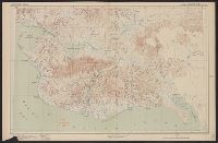
- Beinecke Rare Book and Manuscript Library > Reconnaissance map, southern part of Seward Peninsula, Alaska / topography by E.C. Barnard, D.L. Reaburn, J.G. Hefty ... [et al.].