Skip to search
Skip to main content
Skip to first result
Search
You Searched For
Resource Type
Maps, Atlases & Globes
Creator
Great Britain. War Office. General Staff. Geographical Section
New Search
Search Results
Creator:
Published / Created:
1943
Call Number:
685 Sf18 1943
Container / Volume:
BRBL_00351
Image Count:
1
Resource Type:
Maps, Atlases & Globes
Alternative Title:
GSGS (Series) ; 4275. and Provisional G.S.G.S. ; 4275
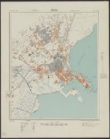
Description:
In upper margin: Tunisia 1:7,500 ... and Principal streets and buildings are named.
Publisher:
Army Map Service, U.S. Army,
Subject (Geographic):
Ṣafāqis (Tunisia)--Maps
Found in:
Beinecke Rare Book and Manuscript Library > Sfax; city plan. Drawn and reproduced by 512 Fd. survey coy. R. E.
Creator:
Published / Created:
1945
Call Number:
56 Sh18 1945
Container / Volume:
BRBL_00297
Image Count:
1
Resource Type:
Maps, Atlases & Globes
Alternative Title:
Geographic Section General Staff ; 3789 and GSGS (Series) ; 3789.
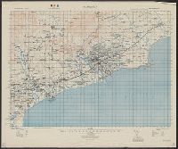
Description:
"9-45.", "Published by the War Office 1927.", At foot of map: Shanghai N3108-E12118/19., At head of map: Eastern China 1:50,000; Sheet 620/1,235., and N3108.
Publisher:
Army Map Service,
Subject (Geographic):
Shanghai (China)--Maps
Subject (Name):
United States. Army Map Service
Found in:
Beinecke Rare Book and Manuscript Library > Shanghai [cartographic material] / Geographical Section, General Staff.
Creator:
Published / Created:
1945
Call Number:
56 Sh19 1945
Container / Volume:
BRBL_00297
Image Count:
1
Resource Type:
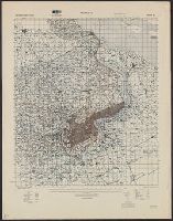
Maps, Atlases & Globes
Alternative Title:
Eastern China 1:50,000: Shanhaikuan and G.S.G.S. ; 3789
Description:
"9-45.", "Geographical Section, General Staff, No. 3789. Published at the War Office 1927. First GSGS Edition (AMS 1), 1927; AMS Revisions (AMS 2), 1944.", "Shanhaikuan N3951-E11929/16x29"--Lower right margin., Includes legend., and Relief is shown by contours.
Publisher:
Army Map Service,
Subject (Geographic):
Shanhaiguan Qu (Qinhuangdao Shi, China)--Maps
Found in:
Beinecke Rare Book and Manuscript Library > Shanhaikuan [cartographic material] / Geographical Section, General Staff.
Creator:
Published / Created:
1943
Call Number:
68 Si13 1943
Container / Volume:
BRBL_00350
Image Count:
1
Resource Type:
Maps, Atlases & Globes
Alternative Title:
Geographical Section, General Staff ; no. 4275 and GSGS (Series) ; 4275.
Description:
"Prepared under the direction of the chief of engineers, U. S. Army, 1943. Compiled from aerial photographs, 1:12,000, G. S. G. S. no. 4275, Sidi Bel Abbès, 1942.", "Projection approximate.", and In upper margin: Algeria 1:10,000 ...
Publisher:
Army Map Service, U. S. Army,
Subject (Geographic):
Sidi Bel Abbès (Algeria)--Maps
Found in:
Beinecke Rare Book and Manuscript Library > Sidi Bel Abbès; city plan.
Creator:
Published / Created:
1914
Call Number:
307 1914
Container / Volume:
BRBL_00036
Image Count:
6
Resource Type:
Maps, Atlases & Globes
Alternative Title:
G.S.G.S. ; no. 2736 and GSGS (Series) 2736.
Description:
Railroads; roads; fortresses; rivers; sheets 2,3,5,6,8,9, -- coverage for France.
Publisher:
War Office, Geographical Section, General Staff,
Subject (Topic):
Transportation--France--Maps
Found in:
Beinecke Rare Book and Manuscript Library > Skeleton map of Western Europe (French 1/500,000) [map].
Creator:
Published / Created:
1918
Call Number:
11hcf 1919D-4
Container / Volume:
BRBL_00010X
Image Count:
1
Resource Type:
Maps, Atlases & Globes
Alternative Title:
G.S.G.S. ; 3703a and GSGS (Series) ; 3703a.
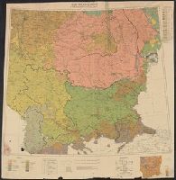
Description:
Includes ancillary map showing density of population.
Publisher:
War Office,
Subject (Geographic):
Balkan Peninsula--Maps
Subject (Topic):
Ethnology--Balkan Peninsula--Maps
Found in:
Beinecke Rare Book and Manuscript Library > South East Europe, ethnographical map [cartographic material].
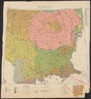
Creator:
Published / Created:
1918
Call Number:
53ed 1918
Container / Volume:
BRBL_00286
Image Count:
1
Resource Type:
Maps, Atlases & Globes
Alternative Title:
G.S.G.S. ; 3703a and GSGS (Series) ; 3703a.
Description:
Includes ancillary map showing density of population.
Publisher:
War Office,
Subject (Geographic):
Balkan Peninsula--Maps
Subject (Topic):
Ethnology--Balkan Peninsula--Maps
Found in:
Beinecke Rare Book and Manuscript Library > South East Europe, ethnographical map [cartographic material].
Creator:
Published / Created:
1918
Call Number:
186 1918
Container / Volume:
BRBL_00013
Image Count:
1
Resource Type:
Maps, Atlases & Globes
Description:
"Ordnance Survey, August, 1918." and Insets: [1.] Bear Island. Scale 1:1,000,000 -- [2. Map of northern Europe.] Scale 1:35,000,000.
Publisher:
[GSGS, War Office],
Subject (Geographic):
Svalbard (Norway)--Maps
Found in:
Beinecke Rare Book and Manuscript Library > Spitsbergen, GSGS 2877.
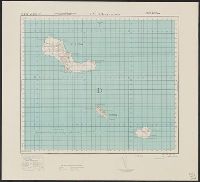
Creator:
Published / Created:
1943
Call Number:
213 Sa59 1943
Container / Volume:
BRBL_00015
Image Count:
1
Resource Type:
Maps, Atlases & Globes
Alternative Title:
G.S.,G.S., ; 4118 and GSGS (Series) ; 4118.
Description:
Elevations shown by form lines and spot heights., In upper margin: Cape Verde ids. ..., Index map cataloged with G. S. G. S. 4117., and Military grid.
Publisher:
Army Map Service, U.S. Army,
Subject (Geographic):
Santa Luzia Island (Cape Verde)--Maps, Topographic
Found in:
Beinecke Rare Book and Manuscript Library > Sta. Luzia and islands / drawn at War Office, 1940, from a Portuguese map of 1932.
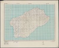
Creator:
Published / Created:
1943
Call Number:
213 Sa 58 1943
Container / Volume:
BRBL_00015
Image Count:
1
Resource Type:
Maps, Atlases & Globes
Alternative Title:
G.S.G.S. ; 4117 and GSGS (Series) ; 4117.
Description:
Elevations shown by form lines and spot heights., In upper margin: Cape Verde ids ..., and Military grid.
Publisher:
Army Map Service, U. S. Army,
Subject (Geographic):
Santo Antão Island (Cape Verde)--Maps, Topographic
Found in:
Beinecke Rare Book and Manuscript Library > Sto Antão / drawn at War Office, 1940, from a Portuguese map of 1930.
Branch:v1.61.8 ,Deployed:2024-06-20T11:15:04-04:00