Skip to search
Skip to main content
Skip to first result
Search
You Searched For
Genre
Maps
Resource Type
Maps, Atlases & Globes
Subject (Topic)
World War, 1914-1918--Maps
New Search
Search Results
Creator:
Published / Created:
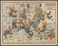
1915
Call Number:
30 1915G
Container / Volume:
BRBL_00032A
Image Count:
2
Resource Type:
Maps, Atlases & Globes
Description:
"Zensur Altona 603.", Caricature map., Caricatures represent international relations., and Includes text.
Publisher:
L. Gräfe,
Subject (Geographic):
Europe--Maps
Subject (Topic):
International relations--20th century--Maps, World War, 1914-1918--Caricatures and cartoons, and World War, 1914-1918--Maps
Found in:
Beinecke Rare Book and Manuscript Library > Sommerschau über Europa 1915 : erweiterte Massstab, 3 gegen 8 / A.K. gez. u. lith.
Published / Created:
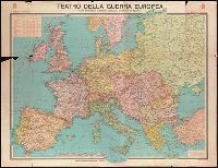
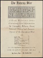
[1918?]
Call Number:
11hc 1915L
Container / Volume:
BRBL_00010C
Image Count:
7
Resource Type:
Maps, Atlases & Globes
Alternative Title:
The Evening Star war map supplement and War map supplement
Description:
"Front Lines" -- "Europe Today" -- "Naval Power" -- "Naval Bases" -- "Europe in 1914" -- "Europe after Versailles" -- "Air Distances" -- "Germany's Supplies". and Includes 8 maps originally published by Rand McNally & Co, Chicago, with text related to maps, a
Publisher:
Evening Star Newspaper Co.,
Subject (Geographic):
Europe--Maps
Subject (Topic):
World War, 1914-1918--Maps
Found in:
Beinecke Rare Book and Manuscript Library > The Evening Star (with Sunday morning edition) war map supplement : a ready-reference atlas containing vital information on geographic, military, naval, historical, political, and economic aspects of the European war / compiled by members of the Star Staf
Creator:
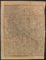
Published / Created:
[1917?]
Call Number:
11hc 1919W
Image Count:
1
Resource Type:
Maps, Atlases & Globes
Description:
Includes text. and Shows worldwide German colonial possessions as of 1913, superimposed on a map of Europe.
Publisher:
Roberts & Leete, Litho., and Stanford's Geogl. Estabt. :
Subject (Geographic):
Europe--Maps and Germany--Politics and government--Maps
Subject (Topic):
World War, 1914-1918--Maps
Found in:
Beinecke Rare Book and Manuscript Library > The downfall of Germany's world-empire / Stanford's Geogl. Estabt., London.
Published / Created:
1918
Call Number:
11hc 1918D
Container / Volume:
BRBL_00010E
Image Count:
2
Resource Type:
Maps, Atlases & Globes
Description:
Laminated page 3 and 4 from The Times, dated November 9, 1918. Text in English on verso.
Publisher:
The Times,
Subject (Geographic):
Belgium--Maps, France--Maps, and Luxembourg--Maps
Subject (Topic):
World War, 1914-1918--Maps
Found in:
Beinecke Rare Book and Manuscript Library > Three Months of Victory on the Western Front.
Creator:
Published / Created:
1915
Call Number:
11hcf 1919E-11
Image Count:
1
Resource Type:
Maps, Atlases & Globes
Alternative Title:
Europe 1:1,000,000, G.S.G.S. ; no. 2758, and GSGS (Series) ; no. 2758.
Description:
Elevation above sea level indicated by colored shading. and Includes index to adjoining sheets, index to boundaries, and pronunciation glossary.
Publisher:
Ordnance Survey,
Subject (Geographic):
Croatia--Maps, Italy--Maps, and Yugoslavia--Maps
Subject (Topic):
World War, 1914-1918--Maps
Found in:
Beinecke Rare Book and Manuscript Library > Triest : North L 33. / compiled at the Royal Geographical Society under the direction of the Geographical Section; drawn and printed by Ordnance Survey.
Creator:
Published / Created:
1915
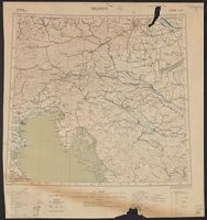
Call Number:
11hcf 1919E-10
Container / Volume:
BRBL_00010Z
Image Count:
1
Resource Type:
Maps, Atlases & Globes
Alternative Title:
Europe 1:1,000,000, G.S.G.S. ; no. 2758, and GSGS (Series) ; no. 2758.
Description:
Copy 2 imperfect. Mutilated. Browned. Inscription: Charles Seymour. and Includes index to adjoining sheets, index to boundaries, and pronunciation glossary.
Publisher:
Ordnance Survey,
Subject (Geographic):
Croatia--Maps, Italy--Maps, and Yugoslavia--Maps
Subject (Name):
Seymour, Charles,--1885-1963--Autograph
Subject (Topic):
World War, 1914-1918--Maps
Found in:
Beinecke Rare Book and Manuscript Library > Triest : North L 33. / compiled at the Royal Geographical Society under the direction of the Geographical Section; drawn and printed by Ordnance Survey.
Creator:
Published / Created:
1915
Call Number:
11hcf 1919E-10
Image Count:
1
Resource Type:
Maps, Atlases & Globes
Alternative Title:
Europe 1:1,000,000, G.S.G.S. ; no. 2758, and GSGS (Series) ; no. 2758.
Description:
Includes index to adjoining sheets, index to boundaries, and pronunciation glossary.
Publisher:
Ordnance Survey,
Subject (Geographic):
Croatia--Maps, Italy--Maps, and Yugoslavia--Maps
Subject (Name):
Seymour, Charles,--1885-1963--Autograph
Subject (Topic):
World War, 1914-1918--Maps
Found in:
Beinecke Rare Book and Manuscript Library > Triest : North L 33. / compiled at the Royal Geographical Society under the direction of the Geographical Section; drawn and printed by Ordnance Survey.
Published / Created:
1918
Call Number:
38hc 1918 Sep. folder
Container / Volume:
BRBL_00172
Image Count:
1
Resource Type:
Maps, Atlases & Globes
Description:
"Druck der Vermess. Abt. 2"., Legend indicates voltage, power lines, transformer stations, power switching stations, front line., Ms. annotations in German. Imperfect: cut around borders., and On verso: Ms. notes: "Komp.-Karte".
Publisher:
s.n.,]
Subject (Geographic):
Lorraine (France)--Maps
Subject (Topic):
Electric lines, World War, 1914-1918--France--Lorraine, and World War, 1914-1918--Maps
Found in:
Beinecke Rare Book and Manuscript Library > Verdun-Point-à-Mousson.
Branch:v1.61.6 ,Deployed:2024-06-12T09:55:19-04:00