Skip to search
Skip to main content
Skip to first result
Search
You Searched For
Genre
Maps
New Search
Search Results
Creator:
Published / Created:
1944
Call Number:
50 1945C
Container / Volume:
BRBL_00273
Image Count:
2
Resource Type:
Maps, Atlases & Globes
Alternative Title:
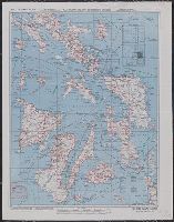
Chart No. C-42, Samar Island, No. C41, Mindoro Island, and Philippine series
Description:
Includes index to sheets, wind force and steadiness of direction of currents., On verso: Chart No. C-42, Samar Island., and Relief shown by gradient tints, contours, and spot heights.
Publisher:
Aeronautical Chart Service,
Subject (Geographic):
Mindoro (Philippines)--Maps and Samar Island (Philippines)--Maps
Subject (Topic):
Aeronautical charts--Philippines--Mindoro--Maps, Aeronautical charts--Philippines--Samar--Maps, Military geography--Philippines--Mindoro--Maps, Military geography--Philippines--Samar--Maps, and World War, 1939-1945-
Found in:
Beinecke Rare Book and Manuscript Library > AAF cloth chart [cartographic material] : no. C41, Mindoro Island / Army Map Service U.S. Army.
Creator:
Published / Created:
1944
Call Number:
50 1945I
Container / Volume:
BRBL_00273
Image Count:
2
Resource Type:
Maps, Atlases & Globes
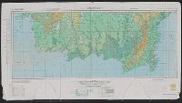
Description:
Cloth map., Includes text., Relief shown by gradient tints, contours, and spot heights., and Text in English and 6 other languages.
Publisher:
Amy Map Service,
Subject (Geographic):
Kunming Region (China)--Maps
Subject (Name):
United States. Aeronautical Chart Service, United States. Army Air Forces, and United States. Army Map Service
Subject (Topic):
Military maps
Found in:
Beinecke Rare Book and Manuscript Library > AAF cloth chart. No. 133, Kun-Ming, Yunnan, China to Chabua, Assam, India Forces / prepared under the direction of the Commanding General, Army Air Forces, for the Aeronautical Chart Service, by the U.S. Coast and Geodetic Survey, Washington, D.C., Januar
Creator:
Published / Created:
1944
Call Number:
50 1945I
Container / Volume:
BRBL_00273
Image Count:
2
Resource Type:
Maps, Atlases & Globes
Description:
Cloth map., Includes text., Relief shown by gradient tints, contours, and spot heights., and Text in English and 6 other languages.
Publisher:
Amy Map Service,
Subject (Geographic):
Kunming Region (China)--Maps
Subject (Name):
United States. Aeronautical Chart Service, United States. Army Air Forces, and United States. Army Map Service
Subject (Topic):
Military maps
Found in:
Beinecke Rare Book and Manuscript Library > AAF cloth chart. No. 133, Kun-Ming, Yunnan, China to Chabua, Assam, India Forces / prepared under the direction of the Commanding General, Army Air Forces, for the Aeronautical Chart Service, by the U.S. Coast and Geodetic Survey, Washington, D.C., Januar
Creator:
Published / Created:
1944
Call Number:
275 1944A
Container / Volume:
BRBL_00023B
Image Count:
1
Resource Type:
Maps, Atlases & Globes
Alternative Title:
No. C-47. and South Borneo
Description:
Map on verso: No. C-48 West Java.
Publisher:
Army Map Service,
Subject (Geographic):
Borneo--Maps
Found in:
Beinecke Rare Book and Manuscript Library > AAF cloth chart. No. C-47. South Borneo.
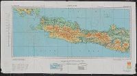
Creator:
Published / Created:
1944
Call Number:
275 1944A
Container / Volume:
BRBL_00023B
Image Count:
1
Resource Type:
Maps, Atlases & Globes
Alternative Title:
No. C-48. and West Java
Description:
Map on verso: No. C-47 South Borneo.
Publisher:
Army Map Service,
Subject (Geographic):
Java (Indonesia)--Maps
Found in:
Beinecke Rare Book and Manuscript Library > AAF cloth chart. No. C-48. West Java.
Branch:v1.61.6 ,Deployed:2024-06-12T09:55:19-04:00