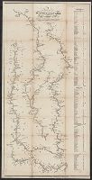
"Engraved by Thos. Twichell for Doolittle & Munson.", "Entered according to act of Congress in the year 1842 by Saml. B. Munson ...", and Includes distance list.
Publisher:
Doolittle & Munson,
Subject (Geographic):
Illinois River (Ill.)--Maps., Mississippi River--Maps., Missouri River--Maps., and Ohio River--Maps.
Subject (Name):
Doolittle & Munson, publisher. and Twichell, Thos. (Thomas), engraver.
English text on verso entitled: The description of the kingdom of Tartary, p. 39-40 (signature: V)., Illustrations on left border: A. Samoged -- Tartar genteel woman -- A Tartar -- Tartar country woman., Illustrations on right border: Samoged woman -- Tartar gentleman -- Tartar woman -- Tartar country man., Illustrations on top border: Astrakhan -- Samarkand -- Cambalu -- The House in Nova Zemla., Map folio 39 from: The theatre of the Empire of Great Britaine ... as also a prospect of the most famous parts of the world / John Speed. London : Thomas Bassett & Richard Chiswell, 1676., Map of Tartary [i.e. Mongolia] to the north of China controlled by marauding Mongols in the 13th-14th centuries. The map shows its provinces and cities stretching north from the Himalayas, west to eastern Europe and north of Chinae Regni Pars [i.e. China] and Corea Isle [i.e. Korea]. One feature is the Great Wall of China along the Chinese border on the lower right side of the map. There are many decorative features including along the top of the map pictorial scenes of the cities of Astrakhan, Samarkand and Cambalu, as well as an illustration of a "house in Nova Zemla". Left and right borders eight colourful illustrations of ethnic costumes from some of the peoples of Tartary., Relief shown pictorially., Text at top centre of map reviewing the discovery of Nova Zembla [i.e. the archipelago Novaya Zemlya] by the Dutch explorer William Hollander in 1594-96., and Watermark.
Covers also town of North Andover and a portion of the City of Lawrence, Massachusetts., Imperfect: Mutilated with slight loss of text. Mounted on board., Relief shown by hachures., and Shows buildings with names of property owners.
Publisher:
Pendleton's Lithogy.,
Subject (Geographic):
Andover (Mass. : Town)--Buildings, structures, etc.--Maps., Andover (Mass. : Town)--Maps., Lawrence (Mass.)--Maps., and North Andover (Mass. : Town)--Maps.
Subject (Name):
Pendleton's Lithography.
Subject (Topic):
Landowners--Massachusetts--Andover (Town)--Maps., Landowners--Massachusetts--Lawrence--Maps., Landowners--Massachusetts--North Andover (Town)--Maps., Real property--Massachusetts--Andover (Town)--Maps., Real property--Massachusetts--Lawrence--Maps., and Real property--Massachusetts--North Andover (Town)--Maps.
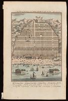
Bird's-eye view of Canton, now Guangzou, China; relief shown pictorially., From: Navigantium atque itinerantium bibliotheca ... / John Harris. -- London : T. Woodward, 1744-1748., In upper right-hand corner: Vol. 1. pa. 359., and Indexed for points on interest.
Publisher:
[T. Woodward],
Subject (Geographic):
Guangzhou (China)--Maps--Early works to 1800.
Subject (Name):
Harris, John, 1667?-1719. Navigantium atque itinerantium bibliotheca.
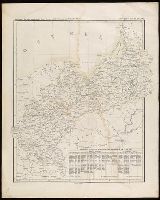
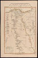
"9"--Manuscript note in upper right corner of sheet. Accompanied by: Title page: A complete body of ancient geography by Mons. D'Anville ... London : James Whittle and Richard Holmes Laurie, 1818 (1 sheet)., Includes index., Includes six bar scales., Prime meridian: Ferro., Relief shown by hachures., and Watermark.
Publisher:
Laurie & Whittle,
Subject (Geographic):
Egypt--Administrative and political divisions--Maps. and Egypt--Maps.
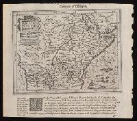
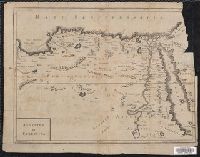
"Octavo, Vol. 2, p. 371" in lower left corner., Imperfect: upper right corner mutilated, with some loss of text. Reinforced on verso with strips of manuscript waste., Relief shown pictorially., and Shows boundaries, rivers and principal settlements.
Publisher:
[publisher not identified],
Subject (Geographic):
Egypt--Historical geography--Early works to 1800--Maps., Egypt--Maps--Early works to 1800., Libya--Historical geography--Early works to 1800--Maps., and Libya--Maps--Early works to 1800.