"P. II. 44" in upper right corner., From P. Santini's Atlas universel, 1784., Prime meridians: Paris; Ferro. Coordinates converted by cataloger to express longitude as measured from the Greenwich meridian., Relief shown pictorially., and This edition was issued in Venice for Francesco Santini and Giuseppi Antonio Remondini's reissue of De L'Isle's Atlas universel.
Subject (Geographic):
Bering Strait Region--Discovery and exploration--Russian--Maps--Early works to 1800., North America--Discovery and exploration--Russian--Maps--Early works to 1800., Pacific Coast (North America)--Discovery and exploration--Maps--Early works to 1800., and Russian Far East (Russia)--Discovery and exploration--Russian--Maps--Early works to 1800.
Subject (Name):
L'Isle, Guillaume de, 1675-1726., Remondini, Giuseppi Antonio, 1747-1811, publisher., and Santini, P. Atlas universel.
Buache, Philippe, 1700-1773 Dezauche, J L'Isle, Guillaume de, 1675-1726. Atlas géographique et universel
Published / Created:
[1781]
Call Number:
23 1750
Container / Volume:
BRBL_00018
Image Count:
1
Resource Type:
Maps, Atlases & Globes
Description:
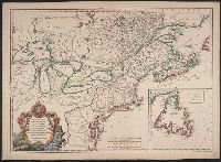
"Advertiss, "Publiée sous le privilège de l'Académie des sciences.", Appears in L'Isle and Buache's Atlas géographique et universel. Paris : Dezauche, 1781-[1784]., Hand col. Mounted on linen. Sheet measures 51 x 71 cm., and Relief shown pictorially.
In lower left margin: 179. 180., In upper right corner: Suppl. 1re. Carte., Relief shown pictorially., and Yale's copy stamped on backing: Yale University Library, Karpinski-Von Wieser Map Collection.
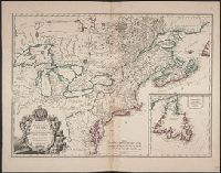
"Avec Privilege ... ", 1st state. Distinguishing feature of 1st state: "Area south of Lake Erie shows Ohio River running east to west, no forts" (Pedley 212)., Also shows Indian lands., Inset map: "Supplément pour l'isle de Terre-Neuve.", and Published separatel
Publisher:
Chés l'auteur, quai de l'horloge du palais proche le pont-neuf ... ,
Subject (Geographic):
Canada--Maps--Early works to 1800, Newfoundland and Labrador--Maps--Early works to 1800, and United States--History--French and Indian War, 1755-1763--Maps--Early works to 1800
Subject (Name):
Argenson, Marc-Pierre de Voyer, comte d', 1696-1764, dedicatee
Subject (Topic):
British--America--Maps--Early works to 1800, Cartographers--France--Paris, French--America--Maps--Early works to 1800, and Indians of North America--Maps--Early works to 1800
1st state. Distinguishing feature of 1st state: "Area south of Lake Erie shows Ohio River running east to west, no forts" (Pedley 212)., Includes "Supplément pour l'isle de Terre-Neuve.", and Shows British colonies as far south as the present state of North Ca
Publisher:
chés l'Auteur,
Subject (Geographic):
Canada--Maps--Early works to 1800, New France--Maps--Early works to 1800, Newfoundland and Labrador--Maps--Early works to 1800, and United States--Maps--Early works to 1800
Subject (Name):
Argenson, Marc-Pierre de Voyer, comte d', 1696-1764. dedication
Subject (Topic):
British--America--Maps--Early works to 1800 and French--America--Maps--Early works to 1800
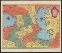
Appears in various eds. of de L'Isle's Atlas nouveau., Bar scales given in "wurst ou mils de Russie," "farsangues ou lieues de Perse," and "lieues communes de France"., Prime meridian: Ferro., Relief shown pictorially., and Sheet measures 54.4 x 63.1 cm. Ms. no.
Publisher:
Chez Jean Cóvens et Corneille Mortier,
Subject (Geographic):
Caspian Sea Region--Maps--Early works to 1800 and Caucasus--Maps--Early works to 1800
Subject (Name):
Cóvens et Mortier and L'Isle, Guillaume de, 1675-1726. Atlas nouveau
Bonnet, Louis Marin, 1736-1793, engraver L'Isle, Guillaume de, 1675-1726
Published / Created:
1723
Call Number:
352 1723
Container / Volume:
BRBL_00104
Image Count:
1
Resource Type:
Maps, Atlases & Globes
Description:
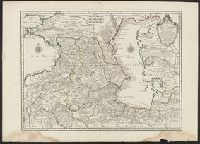
53 1723: Sheet measures 58.6 x 80.9 cm., Bar scales given in "wurst ou mils de Russie," "farsangues ou lieues de Perse," and "lieues communes de France"., Prime meridian: Ferro., Relief shown pictorially., Sheet measures 54.2 x 75.4 cm., and Watermark.
Publisher:
Chez le Sr. Delisle ...,
Subject (Geographic):
Caspian Sea Region--Maps--Early works to 1800 and Caucasus--Maps--Early works to 1800
Bar scales given in "wurst ou mils de Russie," "farsangues ou lieues de Perse," and "lieues communes de France"., Prime meridian: Ferro., Relief shown pictorially., Sheet measures 54.2 x 75.4 cm., Sheet measures 58.6 x 80.9 cm., and Watermark.
Publisher:
Chez le Sr. Delisle ...,
Subject (Geographic):
Caspian Sea Region--Maps--Early works to 1800 and Caucasus--Maps--Early works to 1800