Skip to search
Skip to main content
Skip to first result
Search
You Searched For
Resource Type
Maps, Atlases & Globes
Publication Place
[Washington] :
New Search
Search Results
Creator:
Published / Created:
1945
Call Number:
23ak M58 1945
Container / Volume:
BRBL_00021
Image Count:
1
Resource Type:
Maps, Atlases & Globes
Description:
"No. 5932 ... 31 January 1945."
Publisher:
Reproduction Branch, OSS,
Subject (Geographic):
Micronesia--Maps, Outline and base
Found in:
Beinecke Rare Book and Manuscript Library > Micronesia : [outline maps] / R & A, OSS.
Published / Created:
1913
Call Number:
11hc 1913
Container / Volume:
BRBL_00010A
Image Count:
1
Resource Type:
Maps, Atlases & Globes
Publisher:
U.S. Geological Survey,
Subject (Geographic):
Caucasus--Maps
Found in:
Beinecke Rare Book and Manuscript Library > Mineral Production in the Caucasus / Authority: U.S. Geological Survey.
Creator:
Published / Created:
1934
Call Number:
831fb 1930
Container / Volume:
BRBL_00581
Image Count:
1
Resource Type:
Maps, Atlases & Globes
Publisher:
U.S. Govt. Print. Off.,
Subject (Geographic):
Montana--Administrative and political divisions--Maps
Found in:
Beinecke Rare Book and Manuscript Library > Montana, minor civil divisions : 1930 / Bureau of the Census.
Creator:
Published / Created:
1943
Call Number:
67cbf 1942
Container / Volume:
BRBL_00349
Image Count:
1
Resource Type:
Maps, Atlases & Globes
Description:
"Map no. 797, 3 August 1942." and Relief shown pictorially.
Publisher:
Reproduction Section, O.S.S.,
Subject (Geographic):
Morocco--Maps
Found in:
Beinecke Rare Book and Manuscript Library > Morocco, physiographic diagram / drawn in the Branch of Research and Analysis, OSS.
Creator:
Published / Created:
[1863]
Call Number:
754 1863B
Container / Volume:
BRBL_00416
Image Count:
1
Resource Type:
Maps, Atlases & Globes
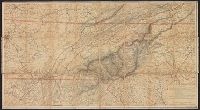
Description:
Copy 2 Imperfect: title along head of map wanting. Copy 2: mounted on linen. On verso: "Wallingford Public Library" plate, stamped "discard"; ms. note "Lt. Col. Goddard.", Includes list of "Authorities.", and Relief shown by hachures.
Publisher:
U.S. Coast Survey,
Subject (Geographic):
North Carolina--Maps and Tennessee--Maps
Subject (Name):
Hawley, Joseph R. (Joseph Roswell), 1826-1905, Krebs, Charles G, Lindenkohl, A, Lindenkohl, H. (Henry), and U.S. Coast and Geodetic Survey
Found in:
Beinecke Rare Book and Manuscript Library > Mountain region of North Carolina and Tennessee / compiled by W.L. Nicholson & A. Lindenkohl, 1863 ; drawn by A. Lindenkohl ; H. Lindenkohl & Chas. G. Krebs, lith.
Creator:
Published / Created:
[1863]
Call Number:
754 1863B
Container / Volume:
BRBL_00416
Image Count:
1
Resource Type:
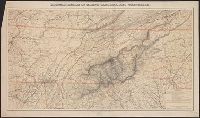
Maps, Atlases & Globes
Description:
Includes list of "Authorities." and Relief shown by hachures.
Publisher:
U.S. Coast Survey,
Subject (Geographic):
North Carolina--Maps and Tennessee--Maps
Subject (Name):
Hawley, Joseph R. (Joseph Roswell), 1826-1905, Krebs, Charles G, Lindenkohl, A, Lindenkohl, H. (Henry), and U.S. Coast and Geodetic Survey
Found in:
Beinecke Rare Book and Manuscript Library > Mountain region of North Carolina and Tennessee / compiled by W.L. Nicholson & A. Lindenkohl, 1863 ; drawn by A. Lindenkohl ; H. Lindenkohl & Chas. G. Krebs, lith.
Creator:
Published / Created:
1875
Call Number:
761 M86 1875
Container / Volume:
BRBL_00448
Image Count:
1
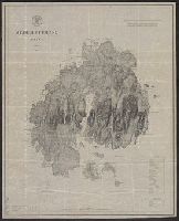
Resource Type:
Maps, Atlases & Globes
Alternative Title:
Coast chart ; no. 103(2), Mount Desert Island Maine, and U.S.C. & G.S. (Series) ; no. 103(2)
Description:
Includes a chart of heights of mountains and hills above mean high water, a chart of summer level of lakes and ponds above mean high water, and latitude and longitude of Baker's I Light House and Mt. Desert light on Green Mt. and Relief shown by hachures.
Publisher:
U.S. Coast and Geodetic Survey,
Subject (Geographic):
Maine--Maps
Subject (Name):
Donn, J. W. (John W.), 1835-1905, Hilgard, J. E. (Julius Erasmus), 1825-1891, and Patterson, C. P. (Carlile Pollock), 1816-1881
Subject (Topic):
Nautical charts--Maine
Found in:
Beinecke Rare Book and Manuscript Library > Mt. Desert Island Maine / C.P Patterson, Superintendent ; verified, J.E. Hilgard, Assistant in Charge of Office ; topography surveyed by J.W. Donn.
Published / Created:
1943
Call Number:
40 N16 1943
Container / Volume:
BRBL_00212
Image Count:
1
Resource Type:
Maps, Atlases & Globes
Alternative Title:
[G.S.G.S.] ; 2549
Description:
"20 August 1943". and In upper right margin: Restricted.
Publisher:
R. & A., OSS,
Subject (Geographic):
Naples (Italy)--Maps
Found in:
Beinecke Rare Book and Manuscript Library > Naples Plan of Port.
Creator:
Published / Created:
1934
Call Number:
824fb 1930
Container / Volume:
BRBL_00572
Image Count:
1
Resource Type:
Maps, Atlases & Globes
Publisher:
U.S. Govt. Print. Off.,
Subject (Geographic):
Nebraska--Administrative and political divisions--Maps
Found in:
Beinecke Rare Book and Manuscript Library > Nebraska, minor civil divisions : 1930 / Bureau of the Census.
Creator:
Published / Created:
[1914?]
Call Number:
831am G45 1920
Container / Volume:
BRBL_00581
Image Count:
1
Resource Type:
Maps, Atlases & Globes
Description:
Bird's-eye view. and Relief shown pictorially and by spot heights.
Publisher:
U.S. Geological Survey,
Subject (Geographic):
Glacier National Park (Mont.)--Aerial views and Glacier National Park (Mont.)--Maps
Subject (Name):
Geological Survey (U.S.)
Found in:
Beinecke Rare Book and Manuscript Library > Panoramic view of the Glacier National Park, Montana / prepared by John H. Renshawe from topographic sheets of the United States Geological Survey ; engraved and printed by the United States Geological Survey.
Branch:v1.61.8 ,Deployed:2024-06-20T11:15:04-04:00