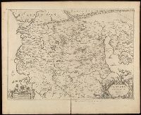
Relief shown pictorially., Verso blank., and Watermark. Manuscript number in upper left corner: 27. Manuscript annotations below neat line.
Publisher:
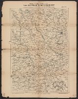
[Jan Jansson],
Subject (Geographic):
Albania, Albania--Maps--Early works to 1800., Europe--Macedonia, Greece--Maps--Early works to 1800., Macedonia (Republic)--Maps--Early works to 1800., and Macedonia--Maps--Early works to 1800.
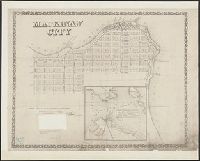
Exposition of the natural position of Mackinaw City.
Container / Volume:
BRBL_00553
Image Count:
1
Resource Type:
Maps, Atlases & Globes
Description:
Elevation shown by spot heights, bathymetry by soundings, in feet., Imperfect: Mutilated with loss of text., Inset: Straits of Mackinaw and vicinity., and Shows property boundaries and proposed railroads and docks.
Publisher:
Middleton, Wallace & Co., lithrs.
Subject (Geographic):
Mackinaw City (Mich.)--Maps
Subject (Name):
De La Vergne, Earl W. pro and Middleton, Wallace & Co
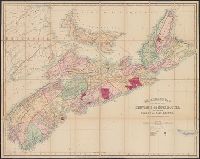
Relief shown by hachures. and Shows settlements, roads, railroads, telegraph lines, gold districts, coal mining areas, post offices, ports of entry, telegraph stations, etc.
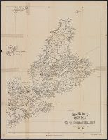
"This map is traced from the Sardinian government map.", "This map is twenty times larger in scale than any map of Northern Italy hitherto published in this country.", "To be followed by other sheets as the exigencies of the war demand.", and Inset map: Skeleton
Sanborn fire insurance maps are a rich source of historic data on the urban built environment of North America during the 19th and early 20th centuries. The atlases were created for the purpose of underwriting fire insurance policies, which depended upon accurate and frequently-updated information about construction materials, municipal and transportation infrastructure, industrial and commercial landuse and more. The Yale University Library Map Department scanned its holdings of Sanborn fire insurance maps (consisting primarily of Connecticut towns) in order to make the maps more accessible.
Alternative Title:
July 1915, Madison, Conn.
Description:
"700. (5 sheets).", Contains information on population, prevailing winds, water facilities and fire department., Includes index of streets and specials., Partial cadastral map., Sheets 1-3 at scale 1:600 ; sheets 4-5 at scale 1:1,200., and SMLMAPL 766 M26 1915: Sheets disbound. Library of Congress copyright stamp on title sheet.
Subject (Geographic):
Madison (Conn.)--Maps
Subject (Name):
Library of Congress Stamp
Subject (Topic):
Fire risk assessment--Connecticut--Madison--Maps and Real property--Connecticut--Madison--Maps