Search
You Searched For
Search Results
- Published / Created:
- [1660?]
- Call Number:
- 3763 1660
- Image Count:
- 2
- Resource Type:
- Maps, Atlases & Globes
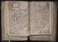
- Description:
- Verso: Text.
- Publisher:
- G. Blaeuw,
- Subject (Geographic):
- Graubünden (Switzerland)--Maps--Early works to 1800
- Found in:
- Beinecke Rare Book and Manuscript Library > Alpinae feu Foederatae Rhaetiae Subditarum quo ei Terrarum nova descriptio. Evert Symons Z. Hamors Vesdt Sculp.
- Creator:
- Blaeu, Willem Janszoon, 1571-1638
Cluver, Philipp, 1580-1622
Symons, Evert van Hamersveldt, engraver
- Published / Created:
- [ca. 1630]
- Call Number:
- 1983 Folio 19
- Collection Title:
- [Atlas factice of 96 maps by Blaeu, Visscher, Jansson, Hondius and others]
- Image Count:
- 1
- Description:
- Sheet measures 39 x 51.2 cm. Reinforced along lower edges with manuscript waste. No. 43 of 92 maps bound together.
- Publisher:
- Guiljelmus Blaeuw excudit
- Subject (Geographic):
- Graubunden (Switzerland) --Maps --Early works to 1800 and Rhaetian Alps --Maps --Early works to 1800
- Subject (Name):
- Hondius, Jodocus, 1594 or 5-1629, dedicator and Pauw, Hadrianus, dedicatee
- Collection Created:
- [1556-1680]
- Found in:
- Beinecke Rare Book and Manuscript Library > Alpinae seu Foederatae Rhaetiae : subditarumque ei terrarum nova descriptio / auctoribus Fortunato Sprechero a Berneck Eq., aur. & I.V.D. Ret. Ac Phil. Cluverio ; Evert Sijmons z Hamers veldt sculp
- Published / Created:
- 1919
- Call Number:
- 383 1919
- Container / Volume:
- BRBL_00177
- Image Count:
- 1
- Resource Type:
- Maps, Atlases & Globes
- Description:
- "G.S.G.S. No. 2909".
- Publisher:
- War Office,
- Subject (Geographic):
- France, Eastern--Maps
- Found in:
- Beinecke Rare Book and Manuscript Library > Alsace-Lorraine.
- Published / Created:
- [191-?]
- Call Number:
- 11hcf 1919D-41
- Container / Volume:
- BRBL_00010X
- Image Count:
- 1
- Resource Type:
- Maps, Atlases & Globes
- Publisher:
- s.n.,
- Subject (Geographic):
- Alsace (France)--Maps
- Found in:
- Beinecke Rare Book and Manuscript Library > Alsace.
- Published / Created:
- [1630?]
- Call Number:
- 38345 1630A
- Container / Volume:
- BRBL_00178
- Image Count:
- 1
- Resource Type:
- Maps, Atlases & Globes
- Subject (Geographic):
- Bas-Rhin (France)--Maps--Early works to 1800
- Found in:
- Beinecke Rare Book and Manuscript Library > Alsatia Landgraviatus, Cum Suntgoia et Brisgoia. Ger. Mercatare Auctore.
- Published / Created:
- [1912?]
- Call Number:
- Zc82 +912aL
- Image Count:
- 2
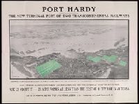
- Alternative Title:
- Alvensleben's twenty acre farms
- Publisher:
- Alvo von Alvensleben, Ltd.,
- Subject (Geographic):
- British Columbia--Port Hardy--Description and travel and British Columbia--Port Hardy--Economic conditions
- Found in:
- Beinecke Rare Book and Manuscript Library > Alvensleben's 20 acre farms : close to the new Terminal City where car meets cargo
- Call Number:
- 1977 1341
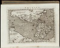
- Collection Title:
- Geographiae vniversae opvs habentur Cl. Ptolemaei ... Geographicae enarationis libri octo [tr. by W
- Image Count:
- 1
- Resource Type:
- Books, Journals & Pamphlets
- Subject (Topic):
- Geography--Early works to 1800
- Collection Created:
- Venetiis : Apud Haeredes Simonis Galignani de Karera, 1596
- Found in:
- Beinecke Rare Book and Manuscript Library > America
- Call Number:
- Gfp94 gf525j
- Collection Title:
- Geographiae vniversae ... opvs ... habentur Cl. Ptolemaei ... Geographicae enarrationis libri octo
- Image Count:
- 1
- Resource Type:
- Books, Journals & Pamphlets
- Subject (Topic):
- Geography--Early works to 1800
- Collection Created:
- Venetiis : Apud Haeredes Simonis Galignani de Karera, 1596
- Found in:
- Beinecke Rare Book and Manuscript Library > America
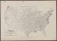
- Creator:
- Goode, J. Paul, 1862-1932
- Published / Created:
- c1910.
- Call Number:
- 75fb 1910A
- Container / Volume:
- BRBL_00410
- Image Count:
- 1
- Resource Type:
- Maps, Atlases & Globes
- Alternative Title:
- Goode's series of base maps ; no. 32B
- Description:
- Shows county boundaries.
- Publisher:
- University of Chicago Press,
- Subject (Geographic):
- United States--Administrative and political divisions--Maps and United States--Maps
- Found in:
- Beinecke Rare Book and Manuscript Library > America (U.S.) by counties.
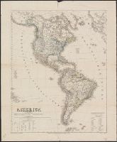
- Creator:
- Kiepert, Heinrich, 1818-1899
- Published / Created:
- 1853
- Call Number:
- 70 1853
- Container / Volume:
- BRBL_00359
- Image Count:
- 1
- Resource Type:
- Maps, Atlases & Globes
- Description:
- Includes text. and Relief shown by hachures.
- Publisher:
- Verlag des Geographischen Instituts,
- Subject (Geographic):
- Western Hemisphere--Maps
- Subject (Name):
- Jungman, Carl
- Found in:
- Beinecke Rare Book and Manuscript Library > America / bearbeitet und gezeichnet von H. Kiepert ; gestochen v. C. Jungmann.