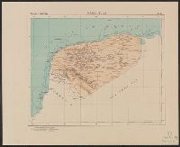
Mexico. Dirección de Estudios Geográficos y Climatológicos
Published / Created:
[1922]
Call Number:
884 1922
Container / Volume:
BRBL_00654
Image Count:
2
Resource Type:
Maps, Atlases & Globes
Alternative Title:
Plano de la ciudad y puerto de Veracruz.
Description:
"No. 30.", Accompanied by physiographic plate covering same area, showing only relief and drainage (1 sheet : col. ; 85 cm.)., Appears in Atlas geográfico de la República Mexicana., Inset: Plano de la ciudad y puerto de Veracruz. Scale 1:25,000., and Relief shown by shading. Depths shown by isolines.
Publisher:
El Dirección,
Subject (Geographic):
Veracruz (Veracruz, Mexico)--Maps and Veracruz-Llave (Mexico : State)--Maps
Subject (Name):
Mexico. Dirección de Estudios Geográficos y Climatológicos. Atlas geográfico de la República Mexicana
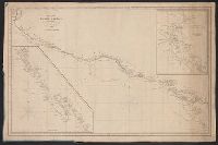
Insets: Harbour of Monterey / surveyed by the officers of the U.S.S. Dale ... 1843. Scale [ca. 1:30,500] -- The Harbour of San Francisco / surveyed by Captn. F.W. Beechey -- [Coast from Port Venderas to San Francisco]. Scale [ca. 1:5,650,000]. and Shows route of "Corvetas Descubierta y Atrevida en 1791."
Publisher:
E. & G.W. Blunt,
Subject (Name):
Beechey, Frederick William, 1796-1856. Harbour of San Francisco
Subject (Topic):
Harbors--California--Monterey--Maps, Naut, Nautical charts--California, Nautical charts--California--Monterey Bay, Nautical charts--California--San Francisco Bay Area, and Nautical charts--Central America
Includes insets of "Harbour of San Francisco, surveyed by Capt. F.W. Beechey" and the west coast from Port Venderas to San Francisco., Relief shown by hachures. Depths shown by soundings., and Shows route of "Corvetas Descubierta y Atrevida en 1791."
Publisher:
E. & G.W. Blunt,
Subject (Name):
Beechey, Frederick William, 1796-1856. Harbour of San Francisco
Subject (Topic):
Harbors--California--Monterey--Maps, Naut, Nautical charts--California, Nautical charts--California--Monterey Bay, Nautical charts--California--San Francisco Bay Area, and Nautical charts--Central America
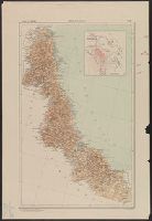
Mexico. Dirección de Estudios Geográficos y Climatológicos
Published / Created:
[1922]
Call Number:
8894 1922
Container / Volume:
BRBL_00656
Image Count:
2
Resource Type:
Maps, Atlases & Globes
Description:
"No. 31.", Accompanied by physiographic plate covering same area, showing mainly relief and drainage (1 sheet : col. ; 48 cm.)., and Relief shown by shading. Depths by isolines.
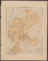
Mexico. Dirección de Estudios Geográficos y Climatológicos
Published / Created:
[1922]
Call Number:
8814 1922
Container / Volume:
BRBL_00651
Image Count:
2
Resource Type:
Maps, Atlases & Globes
Description:
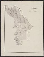
"No. 32.", Accompanied by physiographic plate covering same area, showing only relief and drainage (1 sheet : col. ; 60 cm.)., Appears in Atlas geográfico de la República mexicana., and Relief shown by shading.
Publisher:
La Dirección,
Subject (Geographic):
Zacatecas (Mexico : State)--Maps
Subject (Name):
Mexico. Dirección de Estudios Geográficos y Climatológicos. Atlas geográfico de la República Mexicana
The diaries describe an 1849 expedition by way of St. Joseph, Fort Kearney, Fort Laramie, South Pass, Sublette's Cut-off, Bear River, Cantonment Loring, Raft River, the Humboldt, Lassen's Route to Deer Creek, and Bruff's camp. They contain maps and sketches from the journey and notes on life in California. The journals were written from the diaries. The notebooks contain more sketches from the trip and of equipment. There are memoranda of supplies and equipment, routes, and remedies.
Subject (Geographic):
California --Description and travel, West (U.S.) --Description and travel, West (U.S.) --Maps, and West (U.S.) --Pictorial works
Subject (Name):
Bruff, Joseph Goldsborough, 1804-1889 and Washington City and California Mining Association
Subject (Topic):
Gold mines and mining --California --History --19th century --Personal narratives, Gold mines and mining --North America --History --19th century, Gold mines and mining --Sierra Nevada (Calif. and Nev.), Gold mines and mining --United States --History, and Gold mines and mining --West (U.S.) --History --19th century
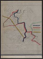
Boundary lines noted in hand-colored ink., Ms. notes along bottom right margin: "Taken from map without title, property of the United Fruit Co.", and Positive photostat.
From the Streeter collection., Pen-and-ink and watercolor., Relief shown by hachur, Shows "Partido del Paso," "Partido de Aldama," and "Partido de Rosales," with New Mexico to the north and Coahuila and Texas to the east., Spanish., and Title devised by cataloger.
Subject (Geographic):
Chihuahua (Mexico : State)--Maps, Manuscript, Coahuila and Texas (Mexico)--Maps, Manuscript, and New Mexico--Maps, Manuscript