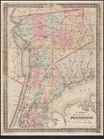
Includes key to symbols. and Includes Long Island and adjoining portions of Massachusetts, Rhode Island, and New York, including the Hudson River Valley northward to Malden.
Publisher:
G. W. and C. B. Colton,
Subject (Geographic):
Connecticut--Maps, Hudson River Valley--Maps, Long Island (N.Y.)--Maps, New York (State)--Maps, and Rhode Island--Maps
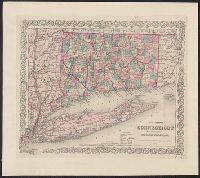
1 inch = ca. 10 miles., Advertisement for their maps, on front pastedown., Colored by town; borders of counties and of states in red., and In brown cloth covered folder, with "Colton's Map of Connecticut" and publisher's name in gold, surrounded by curvilinear d
Publisher:
G.W. and C.B. Colton,
Subject (Geographic):
Connecticut--Maps, Long Island (N.Y.)--Maps, and New York (State)--Maps
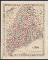
"Entered according to Act of Congress in the year 1884 by G.W. & C.B. Colton & Co. in the office of the Librarian of Congress at Washington.", From Maine state year-book and annual register, for the year 1884., and Shows county, town, and unincorporated townshi
"Entered according to Act of Congress in the year 1883 by G.W. & C.B. Colton ...", In upper left and right margins: No. 45, No. 46., Includes 2 insets: Beaufort Harbor -- Plan of Charleston, vicinity and harbor., Relief shown by hachures and spot heights., and Sh
Publisher:
G.W. and C.B. Colton & Co.,
Subject (Geographic):
North Carolina--Maps and South Carolina--Maps
Subject (Name):
Colton, G. Woolworth (George Woolworth), 1827-1901 and Kerr, Washington Caruthers, 1827-1885
Subject (Topic):
Railroads--North Carolina--Maps and Railroads--South Carolina--Maps
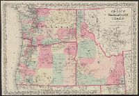
"Entered according to act of Congress in the year 1876 by G.W. & C.B. Colton ....", Also covers southwestern Montana., Prime meridians: Greenwich and Washington., Relief shown by hachures., and Shows counties, railroads, camps, and Indian reservations.
Publisher:
G.W. and C.B. Colton,
Subject (Geographic):
Northwest, Pacific--Maps
Subject (Topic):
Indians of North America--Northwest, Pacific--Maps, Military bases--Northwest, Pacific--Maps, and Railroads--Northwest, Pacific--Maps
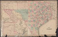
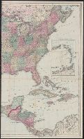
"Entered according to act of Congress in the year 1873 by G.W. & C.B. Colton & Co. in the office of the Librarian of Congress at Washington.", Insets: Plan of Matagorda Bay. Scale [ca. 1:1,060,000] -- Plan of the, and Prime meridians: Greenwich and Washington.
Publisher:
G.W. & C.B. Colton & Co.,
Subject (Geographic):
Texas Panhandle (Tex.)--Maps, Texas--Administrative and political divisions--Maps, and Texas--Maps
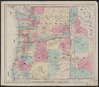
Colton's map of Oregon and Washington Territory and Map of Oregon & Washington Territory
Description:
"Entered according to act of Congress in the year 1879 by G.W. & C.B. Colton & Co. ....", Includes ill. of steamships along Oregon Steamship Co. and Alaska & Sitka Steamer routes., Prime meridians: Greenwich and Washington, D.C., Relief shown by hachures., and Shows Oregon, Washington, and western Idaho.
"Entered according to Act of Congress in the year 1867 by G.W. & C.B. Colton & Co. ...", Hand col., and Shows roads, railroads, and projected railroads.