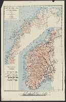
Descriptio ac delineatio geographica detectionis freti, sive, transitus ad occasum supra terras
Image Count:
1
Abstract:
Map depicts the Coat of Arms of the United Kingdom (era of the Union of the Crowns), reigning between the years 1603-1707.
Alternative Title:
Tabula nautica ...
Description:
Bound in after p. [6]., In ink on recto: place names "Okkak", "Nain"[?] and one longer handwritten note on the bottom margin., Map cut and folded irregularly., Map has been repaired with multiple pieces of tape on verso., Map has multiple small stains on both the recto and verso., Printed on recto in lower right corner: A1., and Scale [ca. 1:9,000,000].
Subject (Geographic):
North Atlantic Ocean --Maps --Early works to 1800
Subject (Name):
Hudson, Henry, d. 1611
Collection Created:
Amsterodami Ex officina Hesse lij Gerardi. Anno 1613
Henri Crublier d'Opterre journal and maps, [1776]-1783.
Container / Volume:
Bsd folder 10
Image Count:
3
Subject (Geographic):
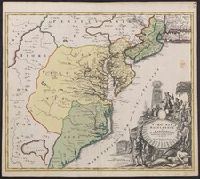
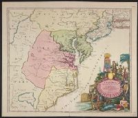
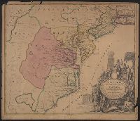
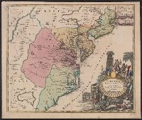
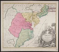
America--Maps--Early works to 1800, Portsmouth (N.H.)--Maps--Early works to 1800, and United States--History--Revolution, 1775-1783--Maps--Early works to 1800.
Also covers Delaware, southern Pennsylvania, New Jersey, western Long Island, southwestern Connecticut, and portions of adjacent areas., Bar scale given in "milliaria Germanica"., First appe, Includes ill., and Relief shown pictorially. Depths shown by soundings.
Also covers Delaware, southern Pennsylvania, New Jersey, western Long Island, southwestern Connecticut, and portions of adjacent areas., Bar scale given in "milliaria Germanica"., Includes ill., Relief shown pictorially. Depths shown by soundings., and Title in L
Also covers Delaware, southern Pennsylvania, New Jersey, western Long Island, southwestern Connecticut, and portions of adjacent areas., Bar scale given in "milliaria Germanica"., Includes ill., Prime meri, and Relief shown pictorially. Depths shown by soundings.
"Cum privilegio sac. caes. majest.", Also covers Delaware, southern P, Annotated "Quacker" near Philadelphia in red ink, and "100" in black ink on verso., Prime meridian: Ferro., Title in Latin. Place names in Latin, English, and French., and Watermark.
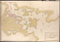
Luisiana, aņo de 1798, sur d'oueste de la ciudad. and Plano de la ciudad de Nueva Orleans.
Description:
"Luisiana, año de 1798, sur d'oueste de la ciudad," in French, Spanish and English, dated Marzo, 16 de 1798, and signed: Carlos Trudeau., "Plano de la ciudad de Nueva Orleans" in French and Spanish, dated 6 de Agosto 1799, and signed at end: Carlos Trudeau., At foot of map, "Luisiana, año de 1798 ... ": Recorded in the Book No. 3, page 216, New Orleans, juin 3th 1808. Van Pradelles ..., Maps are hand colored. Old fold marks visible., and Two folding plans of New Orleans by Charles Trudeau; to accompany Thierry's Examen des droits des Etats Unis ... , Nouvelle-Orleans, De l'imprimerie de Thierry & Co., 1808.
Publisher:
s.n.,
Subject (Geographic):
New Orleans (La.)--Maps
Subject (Name):
Thierry, J. B. S. (Jean Baptiste Simon), d. 1815. Examen des droits des Etats-Unis et des pretentions de Mr. Edouard Livingston sur la batture en face du faubourg Ste. Marie. and Thierry, J. B. S.--(Jean Baptiste Simon),--d. 1815.--Examen des droits des Etats-Unis et des pretentions de Mr. Edouard Livingston sur la batture en face du faubourg Ste. Marie.