Skip to search
Skip to main content
Skip to first result
Search
You Searched For
Genre
Maps
Language
English
New Search
Search Results
Published / Created:
[1794?]
Call Number:
50 1794
Container / Volume:
BRBL_00272
Image Count:
1
Resource Type:
Maps, Atlases & Globes
Alternative Title:
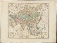
Bowles' new one-sheet map of Asia and New one-sheet map of Asia
Description:
Includes inset of "New Holland" [i.e. Australia]., On verso: 39., and Relief shown pictorially.
Publisher:
Printed for the proprietors, Bowles & Carver, no. 69 St. Paul's church yard,
Subject (Geographic):
Asia--Maps--Early works to 1800
Found in:
Beinecke Rare Book and Manuscript Library > Bowles's new one-sheet map of Asia, divided into its empires, kingdoms, states, and other subdivisions : laid down from observations of the most celebrated geographers.
Published / Created:
[1800?]
Call Number:
755 1800E
Container / Volume:
BRBL_00437
Image Count:
1
Resource Type:
Maps, Atlases & Globes
Description:
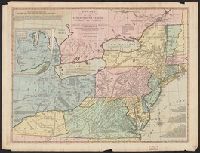
Colored Table of distances in the margin. and Inset: Western part Ohio River.
Publisher:
Bowles & Corver,
Subject (Geographic):
Canada--Maps--Early works to 1800 and East (U.S.)--Maps--Early works to 1800
Found in:
Beinecke Rare Book and Manuscript Library > Bowles's new one-sheet map of the independent States of Virginia, ... Rhode Island, &c ... Habitations and hunting countries of the Confederate Indians; by Lewis Evans.
Creator:
Published / Created:
[1796]
Call Number:
755 1796B
Container / Volume:
BRBL_00436
Image Count:
1
Resource Type:
Maps, Atlases & Globes
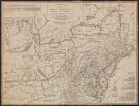
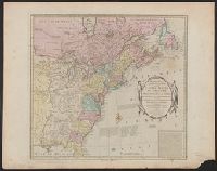
Description:
Includes historical notes, text, 3 distance charts, and inset, "A sketch of the remaining part of Ohio R. &c.", Prime meridians: Philadelphia and London., Relief shown pictorially., Table of distances in the margin., and Watermark.
Publisher:
Printed for the proprietors, Bowles & Carver, No. 69 in St. Paul's Church Yard, London,
Subject (Geographic):
Canada--Maps--Early works to 1800 and Northeastern States--Maps
Subject (Name):
Bowles & Carver
Found in:
Beinecke Rare Book and Manuscript Library > Bowles's new one-sheet map of the independent states of Virginia, Maryland, Delaware, Pensylvania, New Jersey, New York, Connecticut, Rhode Island, &c. : comprehending also the habitations & hunting countries of the confederate Indians / by Lewis Evans.
Published / Created:
[1780?]
Call Number:
40 1780A
Container / Volume:
BRBL_00198
Image Count:
1
Resource Type:
Maps, Atlases & Globes
Publisher:
Printed for ... Carington Bowles ... ,
Subject (Geographic):
Italy--Maps--Early works to 1800
Found in:
Beinecke Rare Book and Manuscript Library > Bowles's new pocket map of Italy ... / by J. Palairet ... ; lately revised and improved ... by L. Delarochette.
Creator:
Published / Created:
[ca. 1771]
Call Number:
71 1771
Container / Volume:
BRBL_00365
Image Count:
1
Resource Type:
Maps, Atlases & Globes
Description:
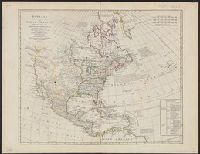
Date taken from description by Stevens and Tree in Tooley's Mapping of America, p. 81, item 56., Includes historical notes and table of "Methodical di, Prime meridian: Ferro., Relief shown pictorially., and Yale's copy stamped on verso: Yale, Horace Brown, 1900S.
Publisher:
Printed for the proprietor Carington Bowles,
Subject (Geographic):
North America--Maps--Early works to 1800
Subject (Name):
Bowles, Carington, 1724-1793 and Palairet, Jean, 1697-1774
Found in:
Beinecke Rare Book and Manuscript Library > Bowles's new pocket map of North America : divided into its provinces, colonies, &c. / by J. Palairet, geographer ; lately revised and improved with many additions, from d'Anville, Mitchel, & Bellin, by L. Delarochette.
Published / Created:
1784
Call Number:
755 1784E
Container / Volume:
BRBL_00435
Image Count:
1
Resource Type:
Maps, Atlases & Globes
Publisher:
Carington Bowles,
Subject (Geographic):
Canada--Maps--Early works to 1800 and East (U.S.)--Maps--Early works to 1800
Found in:
Beinecke Rare Book and Manuscript Library > Bowles's new pocket map of the United States of America ... as settled by the preliminary articles of peace signed at Versailles the 20th Jany. 1783.
Published / Created:
[1795?]
Call Number:
23 1795
Container / Volume:
BRBL_00019
Image Count:
1
Resource Type:
Maps, Atlases & Globes
Publisher:
the Royal Academy of Sciences,
Subject (Geographic):
Pacific Ocean--Maps--Early works to 1800
Found in:
Beinecke Rare Book and Manuscript Library > Bowles's new pocket map of the discoveries made by the Russians on the north west coast of America. Printed for the proprietors, Bowles & Carver ... London.
Published / Created:
[1780?]
Call Number:
755 1780D
Container / Volume:
BRBL_00433
Image Count:
1
Resource Type:
Maps, Atlases & Globes
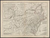
Description:
Inset: Western part of the Ohio River, &c. and Table of distances in margin.
Publisher:
Carington Bowles,
Subject (Geographic):
Canada--Maps--Early works to 1800 and East (U.S.)--Maps--Early works to 1800
Found in:
Beinecke Rare Book and Manuscript Library > Bowles's new pocket map of the middle British Colonies in America, ... habitations and hunting countries of the confederate Indians: by Lewis Evans.
Published / Created:
[1790?]
Call Number:
335 1790
Container / Volume:
BRBL_00086
Image Count:
1
Resource Type:
Maps, Atlases & Globes
Publisher:
Carington Bowles,
Subject (Geographic):
Belgium--Maps--Early works to 1800
Found in:
Beinecke Rare Book and Manuscript Library > Bowles's new pocket map of the ten Catholick Provinces of the Lower Countries, or Netherlands / by J. Palairet ...
Creator:
Published / Created:
1800
Call Number:
32 L84 1800C
Container / Volume:
BRBL_00049
Image Count:
3
Resource Type:
Maps, Atlases & Globes
Alternative Title:
One-sheet plan of the cities of London and Westminster with the borough of Southwark
Description:
Includes a "table of references to the churches and principal buildings ..."
Publisher:
Printed for the proprietors, Bowles & Carver,
Subject (Geographic):
London (England)--Maps and Westminster (London, England)--Maps
Found in:
Beinecke Rare Book and Manuscript Library > Bowles's one-sheet plan of the cities of London and Westminster with the borough of Southwark : comprehending their outskirts and extent of the Thames from Chelsea to Deptford : exhibiting also the new buildings, roads and other alterations.
Branch:v1.61.8 ,Deployed:2024-06-20T11:14:48-04:00