Skip to search
Skip to main content
Skip to first result
Search
You Searched For
Genre
Maps
Language
English
New Search
Search Results
Creator:
Published / Created:
1942
Call Number:
68 B64 1942
Container / Volume:
BRBL_00350
Image Count:
1
Resource Type:
Maps, Atlases & Globes
Alternative Title:
Geographical Section, General Staff ; no.4275 and GSGS (Series) ; 4275.
Description:
"Contours are shown at 20 metre vertical interval.", "Revised and copied from an intelligence plan dated 1935.", In upper margin: Algeria 1:10,000 ..., and Military grid.
Publisher:
Army Map Service, U.S. Army,
Subject (Geographic):
Annaba (Algeria)--Maps
Found in:
Beinecke Rare Book and Manuscript Library > Bône (Algeria).
Creator:
Published / Created:
1667?]
Call Number:
335 1667
Container / Volume:
BRBL_00085
Image Count:
2
Resource Type:
Maps, Atlases & Globes
Description:
Map stamped on verso "Yale University Library Karpinski von Wieser Map Collection".
Publisher:
apud Guiljelmum Blaeuw,
Subject (Geographic):
Belgium--Maps--Early works to 1800
Found in:
Beinecke Rare Book and Manuscript Library > Brabantia Dvcatvs.
Creator:
Published / Created:
1580?]
Call Number:
335 1580
Container / Volume:
BRBL_00085
Image Count:
1
Resource Type:
Maps, Atlases & Globes
Description:
Below title:"Jacobo a Dauetria auct." and Map digitized.
Publisher:
s .n.,
Subject (Geographic):
Belgium--Maps--Early works to 1800
Found in:
Beinecke Rare Book and Manuscript Library > Brabantiae Germaniae inferioris nobilissimae provinciae descriptio.
Published / Created:
1905]
Call Number:
42 V67 1905
Container / Volume:
BRBL_00245
Image Count:
1
Resource Type:
Maps, Atlases & Globes
Publisher:
Bradshaw.,
Subject (Geographic):
Vienna (Austria)--Maps
Found in:
Beinecke Rare Book and Manuscript Library > Bradshaw's Continental Railway Guide : Plan of Vienna.
Published / Created:
[1850]
Call Number:
32 L84 1850
Container / Volume:
BRBL_00050
Image Count:
1
Resource Type:
Maps, Atlases & Globes
Description:
Preliminary record.
Publisher:
Bradshaw & Blacklock Lith.,
Subject (Geographic):
London (England)--Maps
Found in:
Beinecke Rare Book and Manuscript Library > Bradshaw's Plan of London.
Published / Created:
1905]
Call Number:
36 B45 1905
Container / Volume:
BRBL_00122
Image Count:
1
Resource Type:
Maps, Atlases & Globes
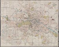
Alternative Title:
Berlin and Plan of Berlin
Publisher:
s.n.,
Subject (Geographic):
Berlin (Germany)--Maps
Subject (Topic):
Streets--Germany--Berlin--Maps
Found in:
Beinecke Rare Book and Manuscript Library > Bradshaw's continental railway guide. 2. Plan of Berlin.
Published / Created:
1857
Call Number:
319gm 1857
Container / Volume:
BRBL_00042
Image Count:
2
Resource Type:
Maps, Atlases & Globes
Description:
Index to name on the margins. and Verso: Ireland
Publisher:
Bradshaw's,
Subject (Geographic):
British Isles--Maps
Found in:
Beinecke Rare Book and Manuscript Library > Bradshaw's map of Great Britain showing the railways completed and in progress with the electric telegraph laid down & the line of navigation from the principal seaports.
Published / Created:
1850
Call Number:
3615 1850
Image Count:
1
Resource Type:
Maps, Atlases & Globes
Subject (Geographic):
Rhine River--Maps
Found in:
Beinecke Rare Book and Manuscript Library > Bradshaw's map of the Rhine from Rotterdam to Schafhausen 1850.
Creator:
Published / Created:
[c1906]
Call Number:
319gme 1906A
Container / Volume:
BRBL_00042
Image Count:
2
Resource Type:
Maps, Atlases & Globes
Description:
"The figures on the map refer to the pages in the guide where the train services are shewn.", Also shows steamship routes and distances., Includes inset of London region and copyright note., and Metropolitan London cab regulations, list of railroad stations in L
Publisher:
Henry Blacklock & Co. Ltd., Engravers and Lithographers,
Subject (Geographic):
British Isles--Maps
Subject (Topic):
Railroad stations--Great Britain--Maps, Railroads--Great Britain--Maps, Railroads--Ireland--Maps, and Steamboat lines--Great Britain--Maps
Found in:
Beinecke Rare Book and Manuscript Library > Bradshaw's railway map of Great Britain and Ireland.
Creator:
Published / Created:
1872
Call Number:
319gme 1872
Container / Volume:
BRBL_00042
Image Count:
2
Resource Type:
Maps, Atlases & Globes
Description:
Inset: London and environs. and Verso: various data.
Publisher:
Bradshaw & Blacklock, London,
Subject (Geographic):
Great Britain--Maps and Ireland--Maps
Subject (Topic):
Railroads--Great Britain--Maps and Railroads--Ireland--Maps
Found in:
Beinecke Rare Book and Manuscript Library > Bradshaw's railway map of Great Britain and Ireland.
Branch:v1.61.8 ,Deployed:2024-06-20T11:15:15-04:00