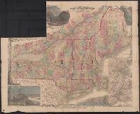
Forty miles around New York., H.H. Lloyd's new map of the great metropolis., H.H. Lloyd's New-York and forty miles around it., New map of the great metropolis., and New-York and forty miles around it.
Description:
Includes lists of maps published by the company (on map) and Relief shown by hachures.
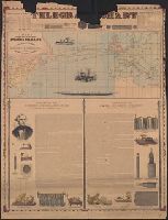
Incl. ill., 2 texts: [1.] Account of the invention and operation of the magnetic telegraph -- [2.] Description of making and laying submarine telegraph cables.
Publisher:
H.H. Lloyd & Co.,
Subject (Geographic):
Atlantic Ocean--Maps
Subject (Topic):
Cables, Submarine--Atlantic Ocean--Maps and Telegraph cables--Atlantic Ocean--Maps
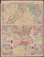
[Virginia, Maryland, Delaware] -- United States -- District of Columbia -- New Orleans, mouth of Mississippi -- Savannah -- Mobile Bay -- Galveston Bay -- Map of Mississippi River [2 maps] -- Cairo -- Pensacola Bay -- Norfolk Harbor -- Hampton Roads. and Reli
Publisher:
H.H. Lloyd : and Published under the auspices of the American Geographical and Statistical Society,
Subject (Geographic):
United States--Maps
Subject (Name):
American Geographical and Statistical Society, Haskins, Charles, and Viele, Egbert L. (Egbert Ludovicus), 1825-1902