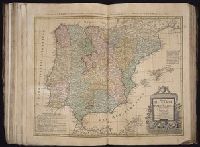
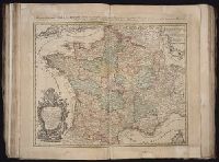
Appears in various eds. of Atlas geographicus maior., Includes German text relating to English and French territorial claims., Place names and descriptive notes in English., Prime meridian: Ferro and London., and Relief shown pictorially.
Publisher:
[s.n.],
Subject (Geographic):
North America--Maps--Early works to 1800. and United States--History--French and Indian War, 1755-1763--Maps--Early works to 1800.
Subject (Name):
Anville, Jean Baptiste Bourguignon d', 1697-1782. and Homann Erben (Firm). Atlas geographicus maior.
"Cum privil. S. Caes. M.", Includes inset view of "St. Petersburg," ornamental cartouche, and text., and Verso: Stamped "Yale Univ. Lib. Map Coll. Nov 21 1975". Lada-Mocarski Collection.
Publisher:
Homann heirs,
Subject (Geographic):
Ingria (Russia)--Maps--Early works to 1800 and Saint Petersburg Region (Russia)--Maps--Early works to 1800
At least three states of the 1746 map exist: one state has the privilige statement "Cum Privil S.C.M." following publisher and preceding date in the cartouche, but without engraver statement "Seb. Dorn, sc." below neat line; another state has no privilege statement, but has engraver statement below neat line; and another state has no privilege statement or engraver statement, but lists "Falkland" below I. Malouines (off the southern coast of Argentia), which is missing from all other states., Relief shown pictorially., and With privilege statement in cartouche. Sheet measures 50 x 59.5 cm. Verso: "8" in ink ms. Franklin Collection.
Publisher:
In lucem proferentibus Homannianis Heredibus,
Subject (Geographic):
America--Maps--Early works to 1800 and Western Hemisphere--Maps--Early works to 1800
Subject (Name):
Boehme, August Gottlieb, 1719-1797 and Hase, Johann Matthias, 1684-1742
Appears in various eds. of Atlas geographicus maior., Includes German text relating to English and French territorial claims., Neat lines measures 45.8 x 50.8 cm. on sheet 50 x 57.5 cm. Ms. note on verso: No. 151, Nord America nach d'Anville. Franklin Collection no. 131 1756-9., Place names and descriptive notes in English., Prime meridian: Ferro and London., and Relief shown pictorially.
Publisher:
[Homann Erben],
Subject (Geographic):
North America--Maps--Early works to 1800 and United States--History--French and Indian War, 1755-1763--Maps--Early works to 1800
Subject (Name):
Anville, Jean Baptiste Bourguignon d', 1697-1782 and Homann Erben (Firm). Atlas geographicus maior
Plan du port et ville de Mahon, du Fort. St. Philippe et ses fortifications
Description:
Includes 2 insets, one showing the islands and the western part of the Mediterranean, and, "Plan du port et ville de Mahon, du Fort. St. Philippe et ses fortifications.", Relief shown by hachures., and Watermark. Manuscript number in upper right corner: 53. From the Karpinski-von Wieser Map Collection.
Publisher:
Communiquée au public par les Hertiers de Homann
Subject (Geographic):
Ibiza (Spain)--Maps--Early works to 1800., Majorca (Spain)--Maps--Early works to 1800., Minorca (Spain)--Maps--Early works to 1800., and St. Philip's Castle (Minorca)--Maps--Early works to 1800.
Subject (Name):
Dorn, Sebastian
Subject (Topic):
Fortifications--Spain--Minorca--Maps--Early works to 1800. and Harbors--Spain--Mahón--Maps--Early works to 1800.
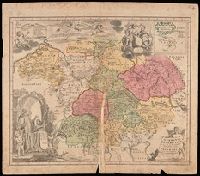
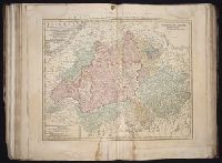
Appears in: Städt-atlas oder Schäuplatz berühmter Städte: Vestungen, Prospekte, Gegenden, Grundrisse, Belagergungen, etc. Nürnberg : Homännischen Erben, 1762., Insets: Landau; Strasburg; Neu Breisach; Fort Louis; Hünningen; Manheim; Philippsburg; Alt Breisach; Freiburg., Manuscript number in lower right corner: 40. From the Karpinski-von Wieser Map Collection., and Relief shown pictorially.
Publisher:
[Homann Erben]
Subject (Geographic):
Baden-Württemberg (Germany)--Maps--Early works to 1800.
Subject (Topic):
Polish Succession, War of, 1733-1738--Maps--Early works to 1800.
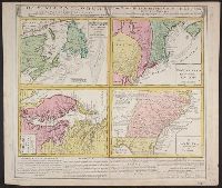
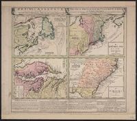
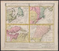
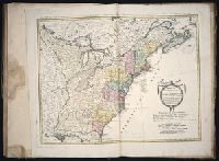
Gros-Britannische Colonie-Lænder in Nord-America, in accuraten Special-Mappen nach den London. Originalien gretreulich mitgetheilt und heraussgegeben von Homaennischen Erben
Description:
A. New Foundland od. Terra Nova, S. Laurentii Bay, die Fisch-Bank, Acadia, nebst einem Theil New Schotland -- B. New Engelland, New York, New Yersey und Pensilvania -- C. Virginia und Maryl, Consists of four maps on one plate., and In Latin, German and English.
Publisher:
Homannianis Hered.,
Subject (Geographic):
Atlantic Coast (Canada)--Maps--Early works to 1800, Atlantic Coast (U.S.)--Maps--Early works to 1800, and Great Britain--Colonies--America--Maps--Early works to 1800
755 1756E: Mounted on paper. Neat line measures 45.9 x 51 cm. on sheet 46 x 51.2 cm. Ms. no.: 54., Includes German text relating to English and French territorial claims., Prime meridian: Ferro and London., Relief sh, and Sheet measures 49.5 x 57.2 cm.
Publisher:
[Homann Erben],
Subject (Geographic):
North America--Maps--Early works to 1800 and United States--History--French and Indian War, 1755-1763--Maps--Early works to 1800
Subject (Name):
Anville, Jean Baptiste Bourguignon d', 1697-1782 and Homann Erben (Firm). Atlas geographicus maior
Appears in various eds. of Atlas geographicus maior., Includes German text relating to English and French territorial claims., Mounted on paper. Neat line measures 45.9 x 51 cm. on sheet 46 x 51.2 cm. Ms. no.: 54., and Place names and descriptive notes in Englis
Publisher:
[Homann Erben],
Subject (Geographic):
North America--Maps--Early works to 1800 and United States--History--French and Indian War, 1755-1763--Maps--Early works to 1800
Subject (Name):
Anville, Jean Baptiste Bourguignon d', 1697-1782 and Homann Erben (Firm). Atlas geographicus maior
Lists "Falkland" below I. Malouines. In other states of this map, the name "Falkland" no longer appears., Relief shown pictorially., and The Yale map collection also has two other states of this map, one state differs in that it has following after the last line of text (and before the date) in the title cartouche: "Cum Privil S.C.M." . The call number is *70.1746A. The other state differs in that it has listed below the neat line the name of the engraver "Seb. Dorn sc." This call number is *70.1746 copy 1. Cross collection no. 131.
Publisher:
in lucem proferentibus Homannianis Heridibus,
Subject (Geographic):
Western Hemisphere--Maps--Early works to 1800
Subject (Name):
Boehme, August Gottlieb, 1719-1797 and Hase, Johann Matthias, 1684-1742
Appears in various eds. of Atlas geographicus maior., Includes German text relating to English and French territorial claims., Place names and descriptive notes in English., Prime meridian: Ferro and London., Relief shown pictorially., and Sheet measures 47.1 x 52 cm. Ms. no. on verso: No. 5. Cross Collection no. 194.
Publisher:
[Homann Erben],
Subject (Geographic):
North America--Maps--Early works to 1800 and United States--History--French and Indian War, 1755-1763--Maps--Early works to 1800
Subject (Name):
Anville, Jean Baptiste Bourguignon d', 1697-1782 and Homann Erben (Firm). Atlas geographicus maior
Gros-Britannische Colonie-Lænder in Nord-America, in accuraten Special-Mappen nach den London. Originalien gretreulich mitgetheilt und heraussgegeben von Homaennischen Erben
Description:
"Mit Kayserl. allergn. Privil." and A. New Foundland od. Terra Nova, S. Laurentii Bay, die Fisch-Bank, Acadia, nebst einem Theil New Schotland -- B. New Engelland, New York, New Yersey und Pensilvania -- C. Virginia und Maryland -- D. Carolina nebst einem The
Publisher:
Homannianis Hered.,
Subject (Geographic):
Atlantic Coast (Canada)--Maps--Early works to 1800, Atlantic Coast (U.S.)--Maps--Early works to 1800, and Great Britain--Colonies--America--Maps--Early works to 1800
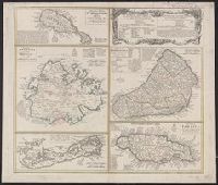
Cross Collection no. 245., Imperfect: map of Jamaica cut-out. Two maps (Antigua and Barbados)., Includes explanatory notes and index., Relief shown pictorially., Scales in millaria Anglica communia and/or millaria Anglica statuta., and Sheet title in Latin and German. Individual map titles and text in German. Maps in English and German.
Publisher:
Homann Erben,
Subject (Geographic):
Antigua--Maps--Early works to 1800, B, Barbados--Maps--Early works to 1800, Jamaica--Maps--Early works to 1800, Saint Kitts and Nevis--Maps--Early works to 1800, and West Indies--Maps--Early works to 1800
Appears in various eds. of Atlas geographicus maior., Includes German text relating to English and French territorial claims., Place names and descriptive notes in English., Prime meridian: Ferro and London., Relief shown pictorially., and Sheet measures 49.5 x 61.7 cm. Title in ms. on verso. Franklin Collection no. 131 1777-1.
Publisher:
[s.n.],
Subject (Geographic):
North America--Maps--Early works to 1800 and United States--History--French and Indian War, 1755-1763--Maps--Early works to 1800
Subject (Name):
Anville, Jean Baptiste Bourguignon d', 1697-1782 and Homann Erben (Firm). Atlas geographicus maior
Gros-Britannische Colonie-Lænder in Nord-America, in accuraten Special-Mappen nach den London. Originalien gretreulich mitgetheilt und heraussgegeben von Homaennischen Erben
Description:
A. New Foundland od. Terra Nova, S. Laurentii Bay, die Fisch-Bank, Acadia, nebst einem Theil New Schotland -- B. New Engelland, New York, New Yersey und Pensilvania -- C. Virgin, In Latin, German and English., and Sheet measures 56 x 64 cm. Franklin Collection.
Publisher:
Homannianis Hered.,
Subject (Geographic):
Atlantic Coast (Canada)--Maps--Early works to 1800, Atlantic Coast (U.S.)--Maps--Early works to 1800, and Great Britain--Colonies--America--Maps--Early works to 1800
Iimage of the Saints Maurus and Placid surrounded by angels in lower left corner., Publisher statement precedes place of publication in imprint., Relief shown pictorially., and Watermark. Manuscript number in right corner: 42. From the Karpinski-von Wieser Map Collection.
Publisher:
Excusa per Haeredes Homan[n]ianos
Subject (Geographic):
Italy--Maps--Early works to 1800.
Subject (Name):
Benedictines and Benedictines--Italy--Maps--Early works to 1800
Subject (Topic):
Ecclesiastical geography and Ecclesiastical geography--Italy--Maps--Early works to 1800.
Imperfect: mutilated along fold, with some loss of text; chipped. Manuscript number in upper right corner: 4. From the Karpinski-von Wieser Map Collection., Includes illustration and inset: Appendix monasteriorum Ord. S. Bened. quae extant in Polonia et Lithuania., Relief shown pictorially., and Shows location of Benedictine monasteries in Holy Roman Empire, Poland, and Lithuania.
Publisher:
[Homann Erben]
Subject (Geographic):
Europe, Central and Germany
Subject (Topic):
Benedictine monasteries--Europe, Central--Maps--Early works to 1800, Benedictine monasteries--Germany--Maps--Early works to 1800, Monasteries--Europe, Central--Maps--Early works to 1800, and Monasteries--Germany--Maps--Early w
Carte generale de la Tartarie chinoise et des royaumes de Corée et de Iapan
Description:
French alternate title only., Imperfect: western sheet (with cartouche) wanting. Sheet measures 54 x 54 cm, with watermark., Includes text and ill., and Relief shown pictorially.
Publisher:
Curis Homannianorum Heredum,
Subject (Geographic):
Chine--Divisions politiques et administratives--Cartes--Ouvrages avant 1800. and Manchuria (China)--Maps--Early works to 1800.
Subject (Name):
Anville, Jean Baptiste Bourguignon d', 1697-1782., Du Halde, J.-B. (Jean-Baptiste), 1674-1743., Gerbillon, Jean-François, 1654-1707., Homann Erben (Firm), and Mayer, Tobias, 1723-1762.
Cross Collection no. 253., Includes explanatory notes and index., Ms. notes in upper right corner., Relief shown pictorially., Scales in millaria Anglica communia and/or millaria Anglica statuta., Sheet title in Latin and German. Individual map titles and text in German. Maps in English and German., and Three maps (Antigua, Barbados, Jamaica). Mounted on linen.
Publisher:
Homann Erben,
Subject (Geographic):
Antigua--Maps--Early works to 1800, Barbados--Maps--Early works to 1800, Bermuda Islands--Maps--Early works to 1800, Jamaica--Maps--Early works to 1800, and Saint Kitts and Nevis--Maps--Early works to 1800
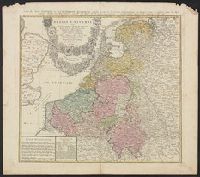
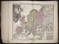
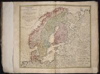
Carte des XVII. provinces ou de l'Allemagne inferievre, dresseé suivant la projection stereographique, et appüyée par les mesures faites de Mess. Cassini, Snellius et Mouschenbrok, par Mr. Tob. Majer de la Societé geographique, et publiée par les Her
Description:
Includes coat-of-arms and 5 bar scales., Relief shown pictorially., Sheet measures 54.6 x 61.5 cm., and Title in Latin and French; legend in Latin.
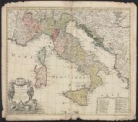
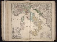
Gli stati d'Italia secondo le osservationi fatte dalla Societa di Se di Parigi, dal R.P. Riccioli della S. die Giesu ed. altri astronomi, di prima geograficamente delineati ... Sgr. de l'Isle ... alle spese degl' heredi d'Homann l'Anno MDCCXLII
Description:
Includes 14 bar scales., Relief shown pictorially., and Sheet measures 54.5 x 61.2 cm.
Publisher:
Curantibus Homannianis Heredibus,
Subject (Geographic):
Italy--Maps--Early works to 1800
Subject (Name):
L'Isle, Guillaume de, 1675-1726 and Riccioli, Giovanni Battista, 1598-1671
Homann Erben (Firm) Homann, Johann Baptist, 1663-1724
Published / Created:
ca. 1730]
Call Number:
319 1720
Container / Volume:
BRBL_00040
Image Count:
1
Resource Type:
Maps, Atlases & Globes
Alternative Title:
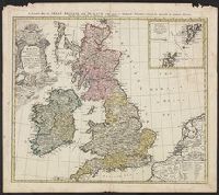
General map of Great Britain and Ireland with part of Holland, Flanders France &c. agreable to modern history by the heirs of late Mr. Homann at Nuremburg
Description:
Graphic scales given in "mill. Anglica" and "milliaria Germ.", Inset, top right: Orcades insulae ... Schetlandicae., Ornate title cartouche, top left, depicting coat of arms and flags., Relief shown pictorially., and Sheet measures 54.5 x 61.9 cm.
Publisher:
Homann Erben,
Subject (Geographic):
Great Britain--Maps--Early works to 1800 and Ireland--Maps--Early works to 1800
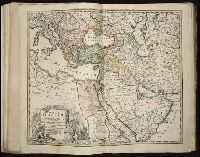
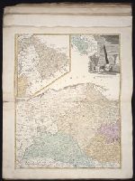
Carte de la Turquie Asiatique contenant la Natolie Moderne divisée en fes Beglerbeys &.
Description:
"C.P.S.C.M.", Bar scales given in "milliaria Germanica," "milliaria Turcica terrestria," and "milliaria Turcica marina"., Imperfect: chewed at edges, witn some loss of text. Sheet measures 48.6 x 54.7 cm., Prime meridian: Ferro., Relief shown pictorially., and Wat
Publisher:
Impensis Homannianorum Heredum,
Subject (Geographic):
Middle East--Maps--Early works to 1800 and Turkey--Maps--Early works to 1800
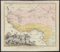
Guinea propria, nec non Nigritiæ vel Terræ Nigrovrm maxima pars, Guinee de meme que la plus grande partie du Pais des Negres, and Gvinee de meme que la plus grande partie du Pais des Negres
Description:
Covers West Africa from Gabon in the south to Niger, Mali, and Mauritania in the north., Has watermark., Includes indexed ill. depicting the dress, dwellings, and work of native Africans., Prime meridian: Ferro., and Relief shown pictorially.
Publisher:
Homannianorum Heredum,
Subject (Geographic):
Africa, West--Maps--Early works to 1800
Subject (Name):
Anville, Jean Baptiste Bourguignon d', 1697-1782 and Marchais, R. de
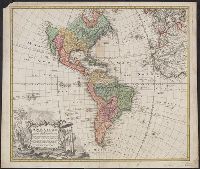
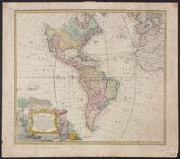
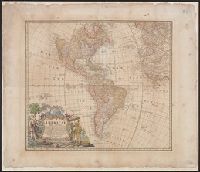
"Seb. Dorn sc.", At least three states of the 1746 map exist: one state has the privilige statement "Cum Privil S.C.M." following publisher and preceding date in the cartouche, but without engraver statement "Seb. Dorn, sc." below, and Relief shown pictorially.
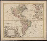
Publisher:
In lucem proferentibus Homannianis Heridibus,
Subject (Geographic):
America--Maps--Early works to 1800 and Western Hemisphere--Maps--Early works to 1800
Subject (Name):
Boehme, August Gottlieb, 1719-1797, Dorn, Sebastian, engraver, and Hase, Johann Matthias, 1684-1742
Imperfect: chewed along edges, with no loss of text. Without privilege statement of engraver statement, but with "Falkland" below I. Malouines (off the southern coast of Argentia). Stamp on verso: Yale University Library, Karpinski-Von Wieser Map Collecti
Publisher:
in lucem proferentibus Homannianis Heridibus,
Subject (Geographic):
America--Maps--Early works to 1800 and Western Hemisphere--Maps--Early works to 1800
Subject (Name):
Boehme, August Gottlieb, 1719-1797 and Hase, Johann Matthias, 1684-1742
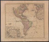
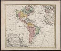
At least three states of the 1746 map exist: one state has the privilige statement "Cum Privil S.C.M." following publisher and preceding date in the cartouche, but without engraver statement "Seb. Dorn, sc." below neat line; anot and Relief shown pictorially.
Publisher:
In lucem proferentibus Homannianis Heredibus,
Subject (Geographic):
America--Maps--Early works to 1800 and Western Hemisphere--Maps--Early works to 1800
Subject (Name):
Boehme, August Gottlieb, 1719-1797 and Hase, Johann Matthias, 1684-1742
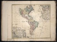
"Seb. Dorn sc.", At least three states of the 1746 map exist: one state has th, Copy 2: Without privilege statement in cartouche and with engraver statement. Stamp on verso: Horace Brown, Yale, 1900S. Sheet measures 53.2 x 64.3 cm., and Relief shown pictorially.
Publisher:
In lucem proferentibus Homannianis Heridibus,
Subject (Geographic):
America--Maps--Early works to 1800 and Western Hemisphere--Maps--Early works to 1800
Subject (Name):
Boehme, August Gottlieb, 1719-1797, Dorn, Sebastian, engraver, and Hase, Johann Matthias, 1684-1742
Guessefeld, F. L. (Franz Ludwig), 1744-1807 Homann Erben (Firm)
Published / Created:
1775
Call Number:
1983 Folio 23
Collection Title:
[Atlas factice of 50 maps, primarily by Johann Baptist Homann and/or issued by the Homann Erben
Image Count:
1
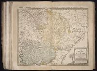
Publisher:
Impensis Homannianorum Haeredum
Subject (Geographic):
Bohemia (Czech Republic) --Maps --Early works to 1800, Galicia (Poland and Ukraine) --Maps --Early works to 1800, and Ukraine --Maps --Early works to 1800
[Atlas factice of 50 maps, primarily by Johann Baptist Homann and/or issued by the Homann Erben
Image Count:
1
Alternative Title:
Carte des etats de la Covronne de Pologne
Publisher:
Luci publicae tradita per Homannianos Heredes
Subject (Geographic):
Belarus --Maps --Early works to 1800, Lithuania --Maps --Early works to 1800, Poland --Maps --Early works to 1800, and Ukraine --Maps --Early works to 1800
Gussefeld, F. L. (Franz Ludwig), 1744-1807 Homann Erben (Firm) Schmidt, I. M.
Published / Created:
ao. 1784
Call Number:
1983 Folio 23
Collection Title:
[Atlas factice of 50 maps, primarily by Johann Baptist Homann and/or issued by the Homann Erben
Image Count:
1
Alternative Title:
Treize Etats Unis de l'Amerique septentrionale, d'apress les meilleurs & speciales cartes angloises qui ont parues jusqu'ici and XIII Etats Unis de l'Amerique septentrionale, d'apress les meilleurs & speciales cartes angloises qui ont parues jusqu'ici
Homann Erben (Firm) Homann, Johann Baptist, 1663-1724
Published / Created:
[ca. 1730]
Call Number:
1983 Folio 23
Collection Title:
[Atlas factice of 50 maps, primarily by Johann Baptist Homann and/or issued by the Homann Erben
Image Count:
1
Alternative Title:
General map of Great Britain and Ireland with part of Holland, Flanders France &c. agreable to modern history by the heirs of late Mr. Homann at Nuremburg
Publisher:
[Homann Erben]
Subject (Geographic):
Great Britain --Maps --Early works to 1800 and Ireland --Maps --Early works to 1800
Homann Erben (Firm) L'Isle, Guillaume de, 1675-1726 Riccioli, Giovanni Battista, 1598-1671
Published / Created:
[1742?]
Call Number:
1983 Folio 23
Collection Title:
[Atlas factice of 50 maps, primarily by Johann Baptist Homann and/or issued by the Homann Erben
Image Count:
1
Alternative Title:
Gli stati d'Italia secondo le osservationi fatte dalla Societa di Se di Parigi, dal R.P. Riccioli della S. die Giesu ed. altri astronomi, di prima geograficamente delineati ... Sgr. de l'Isle ... alle spese degl' heredi d'Homann l'Anno MDCCXLII
[Atlas factice of 50 maps, primarily by Johann Baptist Homann and/or issued by the Homann Erben
Image Count:
1
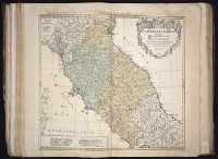
Alternative Title:
Etats de l’Eglise & du Grand Duche de Toscane, Etats de l’Eglise & du Grand Dvche de Toscane, and Status Ecclesiastici nec non Magni Ducatus Toscanae nova tabula geographica
Publisher:
Curantibus Homannianis Heredibus
Subject (Geographic):
Papal States --Maps --Early works to 1800 and Tuscany (Italy) --Maps --Early works to 1800
Homann Erben (Firm) Homann, Johann Baptist, 1663-1724
Published / Created:
[1741?]
Call Number:
1983 Folio 23
Collection Title:
[Atlas factice of 50 maps, primarily by Johann Baptist Homann and/or issued by the Homann Erben
Image Count:
1
Alternative Title:
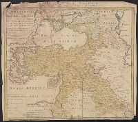
Allemagne distingue?e en ses cercles & subdivise?e en ses e?tats, contenant son e?tendue pre?sente rectifie?e & me?thodiquement enlumine?e suivant les e?le?ments de ge?ographie de Mr. Schatz a 1741 avec privilege imperial and Imperii Romano Germanici in suos status et circulos divisi tabula generalis
Publisher:
[Homann Erben?]
Subject (Geographic):
Austria --Maps --Early works to 1800, Czechoslovakia --Maps --Early works to 1800, Germany --Maps --Early works to 1800, Hungary --Maps --Early works to 1800, and Poland --Maps --Early works to 1800
[Atlas factice of 50 maps, primarily by Johann Baptist Homann and/or issued by the Homann Erben
Image Count:
1
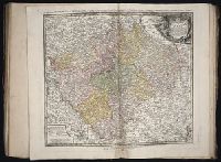
Alternative Title:
Ducatus Silesiae tabula geographica generalis, Duche de Silesie suivant l’e´tat present drese par Tobie Maier, et publie par les Heritiers de Homann a Nuremberg, and Dvche de Silesie suivant l’etat present drese par Tobie Maier, et publie par les Heritiers de Homann a Nuremberg
Publisher:
Impensis Homannianorum Heredum
Subject (Geographic):
Silesia (Czech Republic) --Maps --Early works to 1800
[Atlas factice of 50 maps, primarily by Johann Baptist Homann and/or issued by the Homann Erben
Image Count:
1
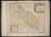
Alternative Title:
Cercle d’Autriche : consistant dans l’Archiduche d’Autriche, le Duche de Stirie, de Carinthie, de Carniole, dans la Comte de Tyrol, et les pais autrichiens anterieurs dans la Souabe, avec ses confins, Circulus Austriacus, and Circvlvs Avstriacvs
Publisher:
Curantibus Homannianis Heridibus
Subject (Geographic):
Austria --Maps --Early works to 1800 and Europe, Central --Maps --Early works to 1800
Hase, Johann Matthias, 1684-1742 Homann Erben (Firm) Homann, Johann Baptist, 1663-1724
Published / Created:
[1737]
Call Number:
1983 Folio 23
Collection Title:
[Atlas factice of 50 maps, primarily by Johann Baptist Homann and/or issued by the Homann Erben
Image Count:
1
Alternative Title:
Tabula ex novissimus ad mentem de L'Islii, inprimis vero celeberrimi geographi Dni. I.M. Hasii, Prof. Vitemb. delineata a. 1737
Description:
Number 13 of 50 works bound together.
Publisher:
[Homann Erben]
Subject (Geographic):
Balkan Peninsula --Maps --Early works to 1800, Egypt --Maps --Early works to 1800, Libya --Maps --Early works to 1800, and Middle east --Maps --Early works to 1800
Boehm, Augustus Gottlieb Hase, Johann Matthias, 1684-1742 Homann Erben (Firm)
Published / Created:
1744
Call Number:
1983 Folio 23
Collection Title:
[Atlas factice of 50 maps, primarily by Johann Baptist Homann and/or issued by the Homann Erben
Image Count:
1
Alternative Title:
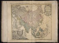
Asia secundum legitimas projectionis stereographicae regulas et juxta recentissimas observationes and Carte de l’Asie, projettee stereographiquement, tiree des relations et observations
Dorn, Sebastian Hase, Johann Matthias, 1684-1742 Homann Erben (Firm)
Published / Created:
1744
Call Number:
1983 Folio 23
Collection Title:
[Atlas factice of 50 maps, primarily by Johann Baptist Homann and/or issued by the Homann Erben
Image Count:
1
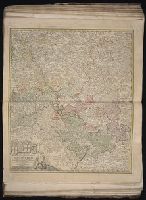
Alternative Title:
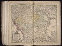
Carte d’Hongrie en general, contenant selon la division ancienne & methodique, la Hongrie, en particulier, la Croatie, la Dalmatie, la Bosnie, la Servie, la Boulgarie, la Principaute de Transylvanie, les Despotats de Walachie & de Moldav and Hungariae ampliori significatu et veteris vel methodicae, complexae regna: Hungariae Propriae, Crotiae, Dalmatiae, Bosniae, Serviae, Cumaniae, principatum: Transylvaniae, despotus: Walachiae, Moldaviae (exclusis ab eadem alienatis Galitia et Ludmomiria) in suas provincias ac partes divisae et quoad Imperantes ex Austriacis, Turcis et Venetis distinctae (juncta tamen propter commidatem Romania vel Romelia Turcica) tabula
Publisher:
Curantibus Homannianis Heredibus
Subject (Geographic):
Balkan Peninsula --Maps --Early works to 1800 and Hungary --Maps --Early works to 1800
[Atlas factice of 50 maps, primarily by Johann Baptist Homann and/or issued by the Homann Erben
Image Count:
1
Alternative Title:
Cours de Danube
Publisher:
Cura Homannianorum Heredum, C.P.S.C.M
Subject (Geographic):
Balkan Peninsula --Maps --Early works to 1800, Danube River Valley --Maps --Early works to 1800, Europe, Central --Maps --Early works to 1800, and Europe, Southern --Maps --Early works to 1800